• Welcome to this forum . We are a worldwide group with a common interest in Birmingham and its history. While here, please follow a few simple rules. We ask that you respect other members, thank those who have helped you and please keep your contributions on-topic with the thread.

    We do hope you enjoy your visit. BHF Admin Team
  • HI folks the server that hosts the site completely died including the Hdd's and backups.
    Luckily i create an offsite backup once a week! this has now been restored so we have lost a few days posts.
    im still fixing things at the moment so bear with me and im still working on all images 90% are fine the others im working on now
    we are now using a backup solution

Old Wharf

Jayell

master brummie
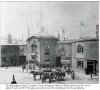
I didn't know quite where to post this picture. I think it must be situated off Broad Street and would like to know more about it. I can see the Council House clock in the background and also probably the steeple of Christ Church. I wonder what date it would be and where the photo was taken from.

Judy

Old Wharf Birmingham.jpg
 
hi judy ive seen this pic before and posted it on the forum but it was a couple of years back and not as good quality as yours..from memory you are right with the location and if that is christ church it was demolished in 1898 i think so that would at least tell us that its before that date...

lyn
 
Judy
Iat was a canal wharf, originally called the Birmingham Coal company wharf, one of the first canal wharfs in birmingham. The Canal company offices facing Paradise st are at the entrance. These have been shown in pictures on the forum - not sure if they have been reposted yet. The picture will have been taken from Bridge St (See map). The building just further away past the tall building on the left in the foreground was Eagle Foundry in late 19th century. On the far left side is half a bulding, which i think was once Brdge st school , and was I think was on the site (or part of) of the Cadburys Bridge st factory
mapc1902-10showingoldwharf.jpg
 
Thanks Mike. It all becomes clear when I look at your map. What date is your map? I know to-day's Bridge Street fairly well, but didn't realise that the photo was as close to Broad Street as that.

Judy
 
This picture is complimentary to the Broad St. Pic. thread. Not a seemly place to have a chocolate factory right by that bridge with all of the coal around. There is a square tower across the street from Cadbury's from the top of which the picture probably was taken. I am not sure now but I think another thread determined that the tower belonged to another school there in which case perhaps a teacher took it. I have seen a clearer reproduction of this shot and thought that the clock on Christchurch was not in sync with Big Brum, which might have indicated that the church was about to be demolished and was in dis-repair. So perhaps a date of around 1898 or slightly before. A slow exposure early camera may not have been able to record moving images of people who might have been there. I think you can see the tower on the photos on the Broad St. Pic. thread.
 
Last edited:
Hi Judy. I have another map to add to Mike's to show the arrangement when it was first laid out. This extract is from 1828. The wharves around this area were laid out in 1824/5. There were 4 canal arms linking to the main canal by a tunnel running beneath Cambridge Street. Someone correct me if I'm wrong but I think Old Wharf would have been one of them. Sir Thomas Gooch's Eagle Foundry sits between Broad Street and Old Wharf. To me this is a really interesting part of Birmingham. There was also supposed to have been a windmill on Bridge Street built before 1775. Viv.

560791fc-bd65-054b.jpg
 
Rupert, thank you for describing the area around the Old Wharf. Your date for the photo of around 1889 was about the time I was thinking, given the date of the demolition of Christchurch given by Lyn. Certainly the siting of a chocolate factory in that area doesn't seem right as there would have been such a lot of dirt and dust around. Loved all your information Rupert. I must go and look at the Broad Street thread again and find that tower.

Judy
 
Great to see another map Viv - unfortunately I was unable to enlarge it enough to see details clearly. Like you, I think this is a fascinating area of working Brum and you can almost visualise the activity which would be going on night and day there loading and unloading cargo. I read somewhere that Old Wharf was also called Paradise Wharf. To see the regeneration around of the canal today is great and has brought life back to an area which badly needed it. I found this today on the Birmingham City Council site which tells all about the Old Wharf.
https://www.birmingham.gov.uk/cs/Sa...806&pagename=BCC/Common/Wrapper/InlineWrapper
 
Viv
I have done a quick look to see when the Old wharf was built, and can't find an exact date written down. Hhowever it is shown on maps dated back to 1778, the first Birmingham Canal was opened in 1772 and the Canal Offices facing Paradise St were built in 1771, so i think around 1771 would be correct.
 
Mike and Viv - From the Birmingham City Council website:

The Old Wharf, which was situated in the square formed by Broad Street (to its North), Easy Row and Suffolk Street (to the East), Holliday Street (to the South) and Bridge Street (to the West), was originally constructed in about the 1770s and used mainly as a coal depot. The Offices of the Birmingham Canal Company were sited alongside the wharf in 1773.
 
Thanks Judy.
Your date for the office is likely to be more accurate ,as mine was taken from beneethe picture of the offices in a book - maybee that 1771 is when they started building it
 
Hi all. I expect the date I quoted must have been when the whole system around the area was completed. That's great that it goes back to the 1770s. It earned its title then! I've had another go with posting the map, not brilliant but hopefully a little improved. Viv.


Old_Wharf_map_1828.JPG
 
Much clearer Viv. Another interesting map. This one you say is dated 1828? More interest for me as it shows Swallow Street, and that is where my 2 x gt.grandmother was living when she married my 2 x gt.grandfather in 1838. I know little about her but know that the street was very close to the Wharf, which would more than likely have looked like this when she lived there.

Judy
 
Viv just out of interest - if it is possible could you post the bit above that wharf - so I can compare it with mikes?

Judy - I love the picture you posted - it really shows what the area was like back then.
 
Hi Polly. I found the map in a report. I think it was an archaelogical survey, but will check. I'll post the full view I have, but I don't know if its far enough north for you. Also it may not magnify very well, but will give it a try. I think the red area must have been the survey area. Viv.ImageUploadedByTapatalk1330100031.995747.jpg
 
No it doesn't magnify very well, so I'll see if I can find the original report. Viv.
 
This picture has been on the forum many times.It shows the wharf offices,it was on Easy Row and directly opposite Paradise Street.Moss
 

Attachments

  • Paradise St.Birmingham waterways office..jpg
    Paradise St.Birmingham waterways office..jpg
    1.4 MB · Views: 46
Thanks Viv and Mike - I was just trying to see what the site of Baskerville house looked like on the earlier map - maybe would have helped if I had said that in my post - silly me!!
 
I have seen that photo before MossG. But seeing it again after the photo of the Old Wharf puts it into perspective.

Judy
 
You will notice that the Town Hall and Central Library are not in place yet. This is the best map so far of the features before these buildings. Baskerville was moved from his tomb by then?
 
These two maps might also be worth putting on this thread. They're both from the same report. Still looking for it and will give the reference when I find it. The maps aren't enlarging very well, so I'd like to find it to get a better copy of them all. But meanwhile here are the two maps; one 1778 and the other 1855. Also I think Baskerville was buried under the windmill mentioned earlier for a short while, but I seem to remember his body being moved to different places. Viv.
ImageUploadedByTapatalk1330107829.710976.jpg

ImageUploadedByTapatalk1330107853.045149.jpg
 
In the 1841 census my gg grandfather's address was listed as "Towing Path Ladywood". He was a boatman but then in 1851 he was a licensed victualler at the Tindal Arms King Edwards Road - so I assume the 1841 address was around the Old Wharf. Think the pub would be about where Sea Life is now.
 
On the older map, the Worcester Canal is not built yet. Two Canal companies met here at the Worcester Wharf and there was a bar between them that did not allow passage of boats for quite a while. So goods being forwarded had to be unloaded and passed over the bar and reloaded on boats on the far side. The canal waters were separate I believe and did not drain into each other back then. You want to hang on to your water level. I think this information was posted on this forum on 'the canals of birmingham' way back by Cromwell. New Hall St. actually led right to the New Hall. Baskerville was buried in a tomb in the garden of his house in a little temple I believe and had to be dug up when the Baskerville Wharfs were put in. It seems like the drive up to his house was kept but most of the premisses were built over by the look of the maps. Although there were riots and his place was burnt down also. There was a fairly long tunnel that led to these wharfs and a lock and pump system also. You can see the tunnel on one map. Actually there are wharf offshutes all over the place...everyone wanted door to door sevice I bet. The 'narrow' nature of the canals and boats made service easier. So whilst we did not have the grand canals...we had the little ones with smaller boats and perhaps by chance of not wanting to move more dirt than necessary...they were just right. There were over 2,500 miles of them mostly linked and still 2000miles today I believe. (might be 3000 my memory is not what it was). I think the weight of dirt moved would have been more than the weight 17 great pyramids. I made the calcs. one time on the back of an envelope...weell you know what happens to such things.
Too bad the Pharoes did not spend their time building canals...might have had a green dessert by now. Actually this brings to mind a TV program on the Raj in India. Seems we Brits thought canals would be good there too so they built some. However the inovation did not work too well...the stagnant water spread malaria apparently.
 
That's a lot of interesting info Rupert. It's so good to have members who can interpret these maps and make sense of all the info. I notice that Broad Street isn't marked on Hanson's 1775 map, just a lane surrounded by open land at that stage. This really was the outskirts of the town. Viv.
 
Back
Top