• Welcome to this forum . We are a worldwide group with a common interest in Birmingham and its history. While here, please follow a few simple rules. We ask that you respect other members, thank those who have helped you and please keep your contributions on-topic with the thread.

    We do hope you enjoy your visit. BHF Admin Team
  • HI folks the server that hosts the site completely died including the Hdd's and backups.
    Luckily i create an offsite backup once a week! this has now been restored so we have lost a few days posts.
    im still fixing things at the moment so bear with me and im still working on all images 90% are fine the others im working on now
    we are now using a backup solution

Old street pics..

Golden Hillock Road Small Heath.jpg

Golden Hillock Road, Small Heath. I remember being sent to The Sydenham on the left one Saturday evening because trouble was expected.
 
Watery Lane and what looks like No 6 on the entrance to a courtyard where the women are standing and maybe a pub on the corner.
index.php

shoothill
from forum post https://birminghamhistory.co.uk/for...ur-old-street-pics.41947/page-120#post-606273
 
Last edited:
Thanks Mike, I thought I could see '6' chalked on the boards in the entrance but today I can't see it. With a really close look at a metal plate above the entrance I now think I can see 'Court 25' which shows on the other side of the street on your map. Further looking at your map shows the 'bays' of the corner building and possibly the shop next to it and if so the corner is on Keeley Street. I've put an enlargement of the corner building below and it looks like a pub, and three men on the corner look as if they could be waiting for opening time. However, pubs are usually marked 'PH' on maps and this building is not.
WateryLaneKeeleySt.jpg
shoothill
 
Last edited:
Viv
Full pubs were usually named on the maps, but not beerhouses (or off licences). The 1890 Kellys listed no 215 Watery Lane ( from c1951 map), as a beer retailer (that is either a beerhouse or an off licence) run by Henry Henningham. The 1891 census shows him there noting that he was a publican at the White Hart. so it must have been a beerhouse
 
Last edited:
A view of the top of Snow Hill and the station front on Colmore Row, taken from Steelhouse Lane in 1964.
Snow_Hill_1964.JPG
 
Ford Consul behind the bus, Ford Anglia, negative rake rear window emerging turning right into Colmore row.
Sorry to bore you all, but I do like my classic cars as well as my aeroplanes.
I wonder what the advert is for, it appears to use a mirrored backwards on its middle word.
 
whiskey.png
Whiskey came back on sale in Birmingham after WW1.on Dec. 21st 1918.Two enormous lines of thirsty punters formed outside this Dale End store, one stretching back towards the High Street and the other going around Hen's Walk, a side street that is no longer there.
 
Sutton High Street. 1940s
 

Attachments

  • hig street 1940s.jpg
    hig street 1940s.jpg
    107.9 KB · Views: 62
Last edited:
https://birminghamhistory.co.uk/forum/index.php?threads/cable-tramway-inn-hockley.26584/

This small thread has something about the Cable Inn and the same photo, which confirms Hockley.
The tramcar shown was one of those operated by a cable, the channel for which clearly shows in the centre of the two running rails. I am sure Peter Walker wrote about this system so anyone interested might look at the Forum archives written by him.
Presume the cable system was similar to San Francisco's cable cars where the driver is called the brake man.
 
One I have not seen this photo before. I have a feeling it may be Bolton Road Small Heath. However I recall there would have been a Victorian loo just under this bridge.

26056037_10213917101014249_8533278140686964675_n.jpg
 
cracking mort looks familar....just cant make out the name on both of the st/rd signs...hopefully someone will know the location...the bridge should still be there i would think and in fact i think i have passed under it recently...will do a bit of research

lyn
 
Last edited:
mort i thought it looked familar and although taken after your photo ive got these showing bordesley park road on the right...what do you think..looks about right to me

lyn

PARK RD..BORD GR RD 029.JPG PARK RD..BORD GR RD 030.JPG PARK RD..BORD GR RD 031.JPG
 
Last edited:
Spot on I would say. I think the loo was further under the two railway bridges, I am sure you can see it in #5148. Thanks for the additional photos and maps, its bought a bit of the past into context.
 
College Road, Perry Common, near the Mayfair Cinema seen on the right. No date on the pic but it looks 1950s.
College_Rd Mayfair.jpg
 
EC409833-F81E-4A38-8B06-2449F8CA75D3.png Would anyone know if this picture was taken on a Birmingham street and if so where would it be G
 
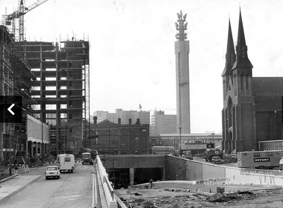
My old school St. Chad's Junior's was behind the cathedral on Shadwell Street. I used to run home on the The St. Chad's Queensway while it was under construction. Don't think I'd do it now.
DIqX1ySXUAERho2.jpg:large
 
Back
Top