• Welcome to this forum . We are a worldwide group with a common interest in Birmingham and its history. While here, please follow a few simple rules. We ask that you respect other members, thank those who have helped you and please keep your contributions on-topic with the thread.

    We do hope you enjoy your visit. BHF Admin Team
  • HI folks the server that hosts the site completely died including the Hdd's and backups.
    Luckily i create an offsite backup once a week! this has now been restored so we have lost a few days posts.
    im still fixing things at the moment so bear with me and im still working on all images 90% are fine the others im working on now
    we are now using a backup solution

Old street pics..

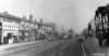
Thanks Phil. The Hockley Hill and Soho Hill photos brought back many memories as I used to live just off Soho Hill, and my first job on leaving school was in Hockley, almost opposite The Palladium, so I walked up and down both those hills regularly as a teenager. Lovely to see the very old photos of how the area used to look as well. It was great to see the old Beehive Pub looking in good condition rather than how it does now! My Dad used to drink in there as it was only a couple of minutes' walk from where we lived.

Judy
 
Thanks Phil,Your photos have brought back things I had completely forgot,IE :- the passage way that went from Hockley to Hunters road,at least I think it was Hunters Road,to the right of the tram in one of your Pictures,and the photos of Soho Road have taken me back to a time when you could say with pride you came from Handsworth,well done and thanks.
 
Whereabouts was the Lucas Social Club on Soho Hill - used to go there on way to Handsworth Tech College for Night School.
 
Bernie,It was on the right hand side going towards Villa Road,before the Church,looking at Phils photos of the church I would say in between the houses and the building next to the Church.
 
Thanks Alan - I will try to recall it - certainly has the right look.
 
Photo 2 #720, corner with Icknield Street must be the Turk's Head, I was so hoping to see a picture of that, thanks.
 
EPW022585.jpg


From this morning's BBC Website feature 'Britain from the Air' here's an indication of how much was lost in the progress of Birmingham being a grand city throughout the whole 1900's century.

So much to see here, although the focus is the Hall of Memory (1928 photograph)
 
morning richie..this looks a fascinating old pic...i will save it and look at it in more detail later on.

thank for posting it

lyn
 
its no good barry i had to have a quick look at that pic...cant believe the area looks so different now...pretty well lost apart from the hall of memory...just a couple of things that maybe someone could confirm..or not lol...

in the middle of the pic can i see what used to be called the big brum clock ???
is that broad st on the right of thei pic..??? if so that maybe the old winfield brass co on the left of the pic...baskerville house had not been built at the time this pic was taken but was built next to winfield brass co.


it would be great to have an overlay map of this pic to show exactly where everything now stands....
lyn
 
Last edited:
Hi Phil

Super pictures it makes you realise how much the area has changed, I remember Mists Garage used to at the top of the hill before they moved to New Oscott.
 
Have annotated some streets etc Lyn. bit difficult to put map on directly because of angle

Hall_of_Memory_from_air_with_names.jpg
 
mike that is brilliant...thank you so much..so pleased that i was right about it being winfield brass on the left...this is a treat to have a pic of it as as far as i know we have not seen one before..im still chuffed that along with myself some of us have got old bricks from this site thanks to the excavation of the site 3 years back...

lyn
 
Thanks Stitcher, just found your post whilst browsing. Nice to know its still fixing up people but I expect most of the nursing staff are near retirement as that was sixty five years ago. Kind regards, david.
 
Have annotated some streets etc Lyn. bit difficult to put map on directly because of angle

Hall_of_Memory_from_air_annotated.jpg

Can I suggest that "Edmund Street" is where "Colmore Row" is, since Colmore Row only went as far as Paradise Street which would be the next on the right, around the bend there..?
 
richie can you see that tower with what looks like a clock face in it just under where it says central methodist hall ?? is that the big brum clock?? i think that was in edmund st in which case you are right..

lyn
 
Last edited:
Richie
You are of course correct. Don't know what I was thinking of. Got my streets in a twist. Have corrected the picture in the original post
 
Lynn
Richie is right
The tower with the clock is Big Brum. The Central Methodist Hall is behind it and much fainter (and rather obscured by my printing)
 
hi mike...wonder if you could switch the streets round on your original map please and i can save and dont worry about it if i had not spotted big brum i would have been non the wiser lol..

lyn
 
Lyn
SorryI took the old one off and thought i had reposted a modified one, but after your request i cehcked and found it hadn't gone on , just a red cross. I can see it now. hope you can also
 
Wonder if it might be Digbeth area?
Just going by the railway arches and is that the river Rea in the picture?
Probably completely wrong!!
 
Yes it is Digbeth area, and clearly shows the GWR viaduct and River Rea. The Midland Red garage isn't built yet but some of the ground for it is cleared with lorries and large vans parked on it. Rea Street on the left, the river just left of centre and Birchall Street on the right head away towards Digbeth (the road).
 
Thanks for the site Richie, realy great photos also thanks to frothblower fot the other info on getting best results on photos many thaks to you both !!!!


Regards Ex Pat Pete
 
Right then, after reaching the top of Soho Hill we come to Soho Rd
 

Attachments

  • Handsworth 191-201  Soho Rd nr Nineveh.jpg
    Handsworth 191-201 Soho Rd nr Nineveh.jpg
    75.6 KB · Views: 130
  • Handsworth Cannon St Memorial Church Soho Rd c1930 .jpg
    Handsworth Cannon St Memorial Church Soho Rd c1930 .jpg
    79.4 KB · Views: 126
  • Handsworth Soho Rd .jpg
    Handsworth Soho Rd .jpg
    62.8 KB · Views: 131
  • Handsworth Soho Rd 1940.jpg
    Handsworth Soho Rd 1940.jpg
    83.5 KB · Views: 130
  • Handsworth Soho Rd 1950.jpg
    Handsworth Soho Rd 1950.jpg
    134.3 KB · Views: 128
Back
Top