-
Welcome to this forum . We are a worldwide group with a common interest in Birmingham and its history. While here, please follow a few simple rules. We ask that you respect other members, thank those who have helped you and please keep your contributions on-topic with the thread.
We do hope you enjoy your visit. BHF Admin Team -
HI folks the server that hosts the site completely died including the Hdd's and backups.
Luckily i create an offsite backup once a week! this has now been restored so we have lost a few days posts.
im still fixing things at the moment so bear with me and im still working on all images 90% are fine the others im working on now
we are now using a backup solution
You are using an out of date browser. It may not display this or other websites correctly.
You should upgrade or use an alternative browser.
You should upgrade or use an alternative browser.
OLD BIRMINGHAM PHOTOS FROM STEVEBHx
- Thread starter SteveBhx
- Start date
Pedrocut
Master Barmmie
Looking at Steve's photo in post#700 .... my thoughts on it's location.
We are looking for a railway on an embankment near a motorway which has a big buttress attached to it
View attachment 154313
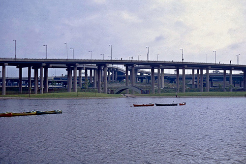
Using Google Earth a location can be found showing a railway near a motorway. It also shows a big buttress and I've only found one of these on the Midland Motorways. The view is southwards looking across the A38(M). However, a tower block is missing!
View attachment 154314
The aerial view below looks 1960s and my large arrow starts where I think the camera was and my small arrow points at a water tower the other side of old factory buildings. Five nearby tower blocks in this view and I remember the dark coloured ones near the lake in the late 1950s. I don't know the date of their demolition ... maybe the taller one behind them was demolished later.
Edit addition the tower block in question was probably 'Normansell Tower' completed 1972 and demolished 2012
View attachment 154315
Old factories and a water tower
View attachment 154316
Map published 1919 showing a tank.

paulinehorton
master brummie
On the right hand building, I am pretty sure we used to go ten-pin bowling. Can anyone confirm, and perhaps have a picture. TIA.Evening all, a bit different tonight.
Old but still there to gone altogether, help needed to work out where and what the last one is
First up good old Villa Park looking a bit different with the Granada Bingo, looks like the players have started to arrive")
Pedrocut
Master Barmmie
A picture I took in the early 70s from the end of Salford Reservoir. It doesn’t help but may be of interest.
 www.ipernity.com
Spaghetti Junction early 1970s (Scan) - Old Birmingham
By Pedrocut. Due to the lack of traffic the picture may have been taken just before the opening of the Gravelly Hill interchange in 1972.
www.ipernity.com
Last edited:
SteveBhx
master brummie
Thanks for all involved a real group effortLooking at Mike's post#708 ... he found the location with a map ... and in my post#720 I confirmed it with pictures ...
Pedrocut
Master Barmmie
My information says this is 11 -17 Summer Row in 1975, there seems to have been a lot of infill here, looking to the left just off picture is Lionel Street if you go down there and first right you find some buildings similar to these!!
Hope that helps Janice, apart from that what outsiders would see as a classic Birmingham view, very 70's.
View attachment 154291
Google 3D view

I don't recall a Brathwath Tank at Aston Wells Pumping Station and I believe that the site was flattened for the construction of the motorway
There was a Ten-pin bowling ally, think it was called Fairlanes then ended up as Granada Bowl.On the right hand building, I am pretty sure we used to go t. Can anyone confirm, and perhaps have a picture. TIA.
RobT
Acemeccanoman
What a lovely view of an old building - 135 - 136 Digbeth in 1970, seen here as one of the original Wing Yip stores, I imagine very exotic in those days. Love the ornamental brickwork and the fancy brackets for signs which they are looking to reuse.
I also see that Count Bartelli is wrestling at Bingley Hall.
View attachment 154164

Alf Rogers
master brummie
The four tower blocks in a line were, from R to L: Boulton Point, James Watt Point, Murdock Point and Priestley Point. They were built (to a very high standard) between 1952-56, to the design of one A.G. Shepperd Fidler, city architect. I believe (although I'm not certain) that the estate as a whole was numbered as 226 Aston Hall Road. The estate was demolished in or around August 2001.Looking at Steve's photo in post#700 .... my thoughts on it's location.
We are looking for a railway on an embankment near a motorway which has a big buttress attached to it
View attachment 154313
Using Google Earth a location can be found showing a railway near a motorway. It also shows a big buttress and I've only found one of these on the Midland Motorways. The view is southwards looking across the A38(M). However, a tower block is missing!
View attachment 154314
The aerial view below looks 1960s and my large arrow starts where I think the camera was and my small arrow points at a water tower the other side of old factory buildings. Five nearby tower blocks in this view and I remember the dark coloured ones near the lake in the late 1950s. I don't know the date of their demolition ... maybe the taller one behind them was demolished later.
Edit addition the tower block in question was probably 'Normansell Tower' completed 1972 and demolished 2012
View attachment 154315
Old factories and a water tower
View attachment 154316
Attachments


Williamstreeter
master brummie
Where has the College of Food , and The Shakespeare pub gone . It's a flaming travesty the way concrete by the ton is just being dumped upon the landscapeThanks for the hint Steve but had a nightmare. The building on the left is Birmingham college of Food which is now University College Birmingham so have done a shot with Lionel Street and UCB on the left - about the best I can do. Most of the buildings no longer seem to exist and Summer Row is pedestrianised now.
I do hope so. I spent many happy hours in there when I was a student at the college in the late 60sI think the Shakespeare is still there.
pjmburns
master brummie
Streetview Oct 2020. UCB (formerly College of Food) on the right.I do hope so. I spent many happy hours in there when I was a student at the college in the late 60s
Attachments

yes it is still there janI think the Shakespeare is still there.
Thank you for the photo. It brings back many happy memories.Streetview Oct 2020. UCB (formerly College of Food) on the right.
Carolann
SteveBhx
master brummie
Kingstanding posting today , a bit of history - taken from discussion with parents who knew those who were involved with those in the start of the church and attended from its opening
For those who live in Kingstanding you will know of John Bunyan Baptist Church with the blue cross on the front over Bandywood Hill from Kingstanding Circle, a bit of history.
In the Boys brigade post there is mention of the 1st A group based at Peoples Chapel in Hockley, members of this church led by Sir Donald Finnemore felt a new church should be built in Kingstanding - the group met at a school in Kingsland Road School while fundraising gathered funds for the church to be built. ( Buy a brick etc)
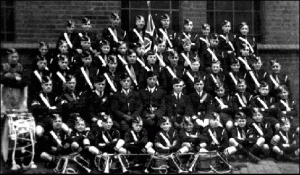
Once the move started a new Boys Brigade the 11th Company was created along with the Girls Brigade, these photos show this .

Vacant land at Lambeth Road and Brockwell Road showing the initial construction of the church
All photos and copyright Mr W Lerwill.
Anything you feel is incorrect please contact me via conversation so I may edit if necessary. ( apologies for E&O )
For those who live in Kingstanding you will know of John Bunyan Baptist Church with the blue cross on the front over Bandywood Hill from Kingstanding Circle, a bit of history.
In the Boys brigade post there is mention of the 1st A group based at Peoples Chapel in Hockley, members of this church led by Sir Donald Finnemore felt a new church should be built in Kingstanding - the group met at a school in Kingsland Road School while fundraising gathered funds for the church to be built. ( Buy a brick etc)
Once the move started a new Boys Brigade the 11th Company was created along with the Girls Brigade, these photos show this .
Vacant land at Lambeth Road and Brockwell Road showing the initial construction of the church
All photos and copyright Mr W Lerwill.
Anything you feel is incorrect please contact me via conversation so I may edit if necessary. ( apologies for E&O )
Attachments

Last edited:

SteveBhx
master brummie
and was soon complete - the church was opened in 1963

There are pictures of the opening at the following forum
https://kingstanding.wordpress.com/memories/ammenaties/churches/john-bunyan-baptish-church/
and of the history of church
 kingstanding.wordpress.com
I also have pictures but as they show too many people I felt it better to post the link.
kingstanding.wordpress.com
I also have pictures but as they show too many people I felt it better to post the link.
There are pictures of the opening at the following forum
https://kingstanding.wordpress.com/memories/ammenaties/churches/john-bunyan-baptish-church/
and of the history of church
The Boys’ Brigade
Memories of the 1stA Birmingham Boys’ Brigade The Company began as the 1st Birmingham Boys Life Brigade Company, and arose from a request by two Boys to Donald Finnemore. At the first meeting…
kingstanding.wordpress.com
Last edited:


great photo steve and yes smashing old cars as wellConstruction progressed quickly - love the cars - Lambeth Road is at the left.
View attachment 154447
Johnfromstaffs
Johnfromstaffs
#742
1937/8 Morris Eight Series 2, pierced steel wheels, not wires as on earlier cars.
1953+ Vauxhall, Velox I think. Cresta would’ve had spats over the back wheels, Wyvern was plainer.
1937/8 Morris Eight Series 2, pierced steel wheels, not wires as on earlier cars.
1953+ Vauxhall, Velox I think. Cresta would’ve had spats over the back wheels, Wyvern was plainer.
Last edited:
Susan shaw
master brummie
Great photos of the Boys Brigade. Although my husband was born in Kingstanding, when he was older he moved to Perry Beeches. It’s there that he joined the Boys Brigade at the Methodist church, Thornbidge Avenue. Regards,Finally a view of a parade outside the front of the church showing a fine selection of shops across the road
View attachment 154452
Last edited:
SteveBhx
master brummie
Bits and pieces day today - If like me you have been looking at Tates Photos on Made in Brum - Old Photos you will have seen #5776 - Compare that view with this one taken on the corner of Bulls Street and dale End in 1970, lot of building work and temporary wires going everywhere.