-
Welcome to this forum . We are a worldwide group with a common interest in Birmingham and its history. While here, please follow a few simple rules. We ask that you respect other members, thank those who have helped you and please keep your contributions on-topic with the thread.
We do hope you enjoy your visit. BHF Admin Team -
HI folks the server that hosts the site completely died including the Hdd's and backups.
Luckily i create an offsite backup once a week! this has now been restored so we have lost a few days posts.
im still fixing things at the moment so bear with me and im still working on all images 90% are fine the others im working on now
we are now using a backup solution
You are using an out of date browser. It may not display this or other websites correctly.
You should upgrade or use an alternative browser.
You should upgrade or use an alternative browser.
Nonsuch Farm
- Thread starter printmeister
- Start date
paul stacey
master brummie
I wonder if someone knows the name of the farm which used to stand on the rhs of the old lane which led to the "black horse" Illey from I think woodgate lane, there was a small hill with a wonderful old wooden barn on it full of owls and my dad and I would go mushrooming early in the mornings usually sundays, I went back a few years ago when dad died and found the M5 ran through it now.
regards
paul
regards
paul
chrisdfacer
proper brummie kid
Hi, Any pictures that I have sent are available to be used by anyone.If I can I will have a look through thse that I have in store but my father,when he was alive he took photo's of eveything,and when he died in 1991 most of his pictures and negatives were destroyed.I will try to get a picture taken off the transparency and re-submit . Chris
john knight
signman
If it's any help here's an 1831 map and a 1916 one.
paul stacey
master brummie
thanks for the maps looks like moll farm,
Local History
master brummie
The first map is showing MOTT Farm (Moat Farm) which was situated facing Field Lane in Kitwell/Wood Lane. Looking at this map, the road the farm Paul is asking about would have been down the road facing James Field Coppice leading to Lower Illey. A map of 1973 shows a farm at the bottom of this road as Lowlands Farm. However, the mention of the M5 and Woodgate Lane makes me wonder if it is Lye Close Farm.
john knight
signman
Here's another couple, 1958 and 1992.
john knight
signman
And a final one 1901.
Could it be moat Farm , shown in 1890 at https://www.british-history.ac.uk/m...sheetid=9253&ox=0&oy=0&zm=1&czm=10&x=338&y=78
mike
mike
paul stacey
master brummie
thanks everyone I remember kettles wood where in the early 50's we got our christmas trees, and I think that lyleclose farm is most proberly the one, so many lovely memories for me from a time now long lost in this mercenary, fast world, just one thing now older I think the old barn must have dated from at least the 16th C and I notice from the maps that there is an abbey listed not far away, I wonder as this barn was some way away from the actual farm whether it was in fact an old tithe barn, ? I also remember old jack who lived in the old cottages past the black horse going towards the main road which led to the "blue bird toffee factory" he came from the black country originally and made his own ginger beer, he would have been in his 80's in the early 50's and the reciept he said came from his grandfather!.
regards all
paul.
regards all
paul.
Hello Chris.
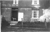
Another great photo to add to my collection of Bartley Green and districts, this one is I think the most "moving" one so far, thank you!. It only needed a little brightness + contrast to make a fairly good picture, except for one detail that is, a detail error which rather surprises me as it makes the whole scene almost unrecognizable. So what is this small error that makes such a difference? The picture is a mirror image and needs flipping horizontally.
Norm
Local History
master brummie
Are your sure Norm? If you are referring to Chris's photo of Nonsuch Farm then I believe Chris has it the 'right way' round. Stonehouse Grove lay to the left of the farm, if flipped it would put Stonehouse Grove towards what was Bartley Green Grammar School.
How sure am I you ask?. Absolutely and without a shadow of doubt 100% sure, I’m also sure that the photo is older than Chris suggested–1955-58. though I haven’t got to grips with that just yet but it maybe 5 years earlier.
Has you say L.H. Stonehouse Grove would be to the left, and you are quite correct, but the photo posted shows it to the right, the large shadows in the right hand corner are the house shadows, the small shadow just above is the shadow of a Oak tree which stood about 15 meters into the field at the top of the grove.
Does it sound as though I’m playing a game, well maybe but never the less It’s all above board.
Norm.
chrisdfacer
proper brummie kid
[img[/img]
how sure am i you ask?. Absolutely and without a shadow of doubt 100% sure, i’m also sure that the photo is older than chris suggested–1955-58. Though i haven’t got to grips with that just yet but it maybe 5 years earlier.
Has you say l.h. Stonehouse grove would be to the left, and you are quite correct, but the photo posted shows it to the right, the large shadows in the right hand corner are the house shadows, the small shadow just above is the shadow of a oak tree which stood about 15 meters into the field at the top of the grove.
Does it sound as though i’m playing a game, well maybe but never the less it’s all above board.
Norm.[/hView attachment 57520ttp://forum.birminghamhistory.co.uk/asset.php?fid=54254&uid=4765&d=1285080608quote]
chrisdfacer
proper brummie kid
Hi,Is this any better.I've put it onto the sanner the right way this time.
Hi,Is this any better.I've put it onto the sanner the right way this time.
Perfect!
hi printmeister if you are still looking in on the forum would it be possible for you to repost the photos that you put on on posts 1 and 2 please...or if any other members may have saved them and could re post that would be great..
many thanks folks
lyn
many thanks folks
lyn
Lyn
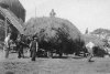
I have 12 pics which I seem to have saved at that time in group labelled Nonsuch Farm. I will post them, though will divide into three posts. not absolutely sure in some cases which are which in the original posts
I have 12 pics which I seem to have saved at that time in group labelled Nonsuch Farm. I will post them, though will divide into three posts. not absolutely sure in some cases which are which in the original posts
Attachments


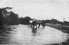

Wow, great photos! Thanks for saving them Mike. Viv.
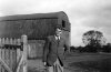
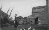
Thank you so much for the photos. My mother lived here for a few years from late 1920's to early 1930's when she was a young girl and has often spoken about the farm She will be thrilled to see themLast four
Bobowler
knowlegable brummie
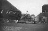
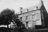
Bostin’ pics Mike, ta for sharing. Good en of the old Farmhouse, if a little skew-whiff! Whilst the other with everyone sitting on the wagon’s a real boster!!
Anyroad, thought I’d add this copy of the old nineteenth-century Ordnance Survey map to things, showing Nonsuch Farm more or less on the doorstep of all the brickworks at California:

Mind not many folk say California these days, which is sad, as I’m one who’s all for keepin’ the old names alive! Still, I’ve been rackin’ me mind tryin’ t’recall if there was ever any actual area signs for the district? I thought there were, but the more I think about it I en’t so sure – anyone out there remember?
Anyroad, thought I’d add this copy of the old nineteenth-century Ordnance Survey map to things, showing Nonsuch Farm more or less on the doorstep of all the brickworks at California:
Mind not many folk say California these days, which is sad, as I’m one who’s all for keepin’ the old names alive! Still, I’ve been rackin’ me mind tryin’ t’recall if there was ever any actual area signs for the district? I thought there were, but the more I think about it I en’t so sure – anyone out there remember?
Last edited by a moderator:
")
Hi Further to your question on the original post a few years ago. I have shown my mother the photos today and she is positive that this is the farm house at Nonsuch Farm . Thanks againLyn
I have 12 pics which I seem to have saved at that time in group labelled Nonsuch Farm. I will post them, though will divide into three posts. not absolutely sure in some cases which are which in the original posts
farmerdave
master brummie
The word "Nonsuch" seems to mean a person or place without equal. The most famous example, as mentioned earlier, was Nonsuch Palace near Cheam in the London Borough of Sutton. It was built in 1538 at the time of Henry VIII and was later a favourite residence of Elizabeth I. It was pulled down in 1682. Nonsuch Park still exists and there is an exhibition centre there which includes a reconstruction model of the Palace. I wonder how long the use of "Nonsuch" for "Nonsuch Farm" in Birmingham has been in existence? Dave.Where does the name Nonsuch come from. Was this term used frequently then I wonder. Maybe 'without rival'. A farm without rival.
In the 1600s a modest ship called 'The Nonsuch' started the fur trade into Hudson Bay.
bewdley
master brummie
i love this thread, i have lived just off summerfield road since 1993 when i was 12 and my great aunt has lived on rushy piece since it was built, if it helps part of summerfield road by the bus stop at warston avenue keeps collapsing and its believed there is a well or pond under the road there.
I think the disused Lapal canal tunnel runs under Woodgate Valley from Lapal Lane at Woodgate towards Selly Oak. I wonder whether this has anything to do with the collapse of the bus stop.
Bewdley
The junction of Summerfield Road and Warston Avenue is marked by the red symbol on this c 1955 map. You can see that it is a fair distance from the tunnel, which is also shown
The junction of Summerfield Road and Warston Avenue is marked by the red symbol on this c 1955 map. You can see that it is a fair distance from the tunnel, which is also shown
