-
Welcome to this forum . We are a worldwide group with a common interest in Birmingham and its history. While here, please follow a few simple rules. We ask that you respect other members, thank those who have helped you and please keep your contributions on-topic with the thread.
We do hope you enjoy your visit. BHF Admin Team -
HI folks the server that hosts the site completely died including the Hdd's and backups.
Luckily i create an offsite backup once a week! this has now been restored so we have lost a few days posts.
im still fixing things at the moment so bear with me and im still working on all images 90% are fine the others im working on now
we are now using a backup solution
You are using an out of date browser. It may not display this or other websites correctly.
You should upgrade or use an alternative browser.
You should upgrade or use an alternative browser.
New unseen photos with no locations
- Thread starter Astoness
- Start date

The aerial photo in post 440 was taken in 1939 and does not show gable-ends close to George St West. In 1940 the "top" shed was built which had gable ends identical to those in the photo (see https://www.warwickshirerailways.com/gwr/gwrhd677.htm , which also includes photo). Proof of the presence of this is also in the picture below taken by me at a time close to that of the original picture of the houses. The end of the shed shows up well. this would agree with the picture of the houses being George St west.

Key Hill Brian
Proud Brummie
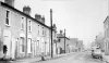
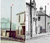
Cracking pic of the front of the houses in #472 - Very reminiscent of my last days in Hockley - There were just 2 families left, side by side with half a house at each end, all forlorn in the midst of a demolition site! At least we could see our house from half a mile away - nothing else standing except the White House!
Brian
Brian
Viewfinder
master brummie
Cracking pic of the front of the houses in #472 - Very reminiscent of my last days in Hockley - There were just 2 families left, side by side with half a house at each end, all forlorn in the midst of a demolition site! At least we could see our house from half a mile away - nothing else standing except the White House!
Brian
Agreed, Brian - the sunlight raking the textures makes a magnificent picture of dereliction. That's another one for the book...
terryb18
Gone but not forgotten R.I.P.
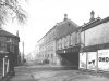
In this picture looking up Pitsford St, you have Icknield St going under the bridge and Carolinas photo is of the building that is behind the car parked on the right. (the 2 storey building). Hope this helps. This photo was taken from the corner of Warstone Lane cemetery, you can just about see the fence.
Attachments

terryb18
Gone but not forgotten R.I.P.
The aerial photo in post 440 was taken in 1939 and does not show gable-ends close to George St West. In 1940 the "top" shed was built which had gable ends identical to those in the photo (see https://www.warwickshirerailways.com/gwr/gwrhd677.htm , which also includes photo). Proof of the presence of this is also in the picture below taken by me at a time close to that of the original picture of the houses. The end of the shed shows up well. this would agree with the picture of the houses being George St west.
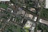
Mikejee your picture shows All Saints School in the middle next to that post, you also have All Saints Rd on the extreme right. I have attached a copy off google earth showing All Saints school circled red and where I think you was standing when you took the picture, circled blue.
Attachments
Viewfinder
master brummie
In this picture looking up Pitsford St, you have Icknield St going under the bridge and Carolinas photo is of the building that is behind the car parked on the right. (the 2 storey building). Hope this helps. This photo was taken from the corner of Warstone Lane cemetery, you can just about see the fence.
Nice picture. I hadn't realised that Scott's use a rare spelling for their oats: 'porage'.
terryb18
Gone but not forgotten R.I.P.
Nice picture. I hadn't realised that Scott's use a rare spelling for their oats: 'porage'.
Never noticed that
")
Here is a new one, though I did ask the question some time ago, with no luck. After the amazing success with most of the previous photos we might be lucky this time.
This photo was taken amongst ones in the Cheapside, Moseley Road area, almost certainly on the same day . The one before was The dog & Partridge, on the corner of Moseley St & Birchall St. the one after was at the corner of Cheapside and Lombard st. Below the picture is shown a map c 1952 showing the two points from where the photos either sidi were taken, and the area around.


This photo was taken amongst ones in the Cheapside, Moseley Road area, almost certainly on the same day . The one before was The dog & Partridge, on the corner of Moseley St & Birchall St. the one after was at the corner of Cheapside and Lombard st. Below the picture is shown a map c 1952 showing the two points from where the photos either sidi were taken, and the area around.
Phil
Gone, but not forgotten.
Phil
Gone, but not forgotten.
Mike
I don't know, I think it would be a bit of a coincidence to have two similar buildings with a chain link fence adjoining in close proximity might the differences be down to camera angle?.
I remember when we first discussed the photo that I put up you said it must be in the same location as the one we are looking for now. Whatever I think it has to be one of the streets that run in the Deritend to Highgate direction because they are all on the flat and the ones that run from Moseley Rd to Sherlock St are all on the hill except at the bottom after Rea St.
Viewfinder
master brummie
To support Phil's theory that this is the same building, note in the shot from the alley a column of brickwork between the building itself and the chain-link fence. This remnant of demolition is also visible in the shot from the street.
I have a slight problem, in that the version I sent phil has a slightly wider view than any version I can find on my computer. The on eon my computer is slightly cropped on the left hand side. i will have to find the original and re-scan it. That said, I enlarged two parts of the photo at the far left of the building, and lightened "Phil's" photo. At first I thought they could not be the same as the alleyway phot seemed to have a side building with the roodf sloping towards the road, whereas the other had a roof sloping at right angles to that, away from the building. But with the enlargement the alleyway photo has two tanks on top of a building and an angular line which could be a roof sloping away from the building. Hope that makes sense to you. See below:


Viewfinder
master brummie
I read the roofs like this: The angled line we see from both the alley and the street is the sloping roof of the brick projection. This is best identified in the 'three-quarter view' from the street, directly above the chain-link fence. The other roof - beyond and above this projection, seen from the alley - is beyond the left edge of the frame in the shot from the street.
Phil
Gone, but not forgotten.
Mike
If you look at your first enlarged section from the view down the passageway, you will see that there is indeed a sloping structure in front of the building that you point out which could be behind the first structure and out of view on the photo I posted.
In reality it makes no difference because even if the two photos relate to each other then we still have to identify the street, and I was unable to do that a couple of years ago, and I'm still no wiser now.
I think I have solved it Phil. Took the photo of the building, lightened it , enlarged and messed around and looked at the sign on the side. thought it looked like Toye at first, but none round there. Then thought Tonks and there was a Tonks (Birmingham )Ltd, Star Waorks, Moseley st in 1962 between Birchall st and Lombard st. Could not find an alleyway on any maps that corresponded to a single building opposite, but the Works also went onto Birchall St, and there is an alleyway there with a building next to some houses (which likely were demolished pre my photo). The enlarged sign , and the map showing the alleyway (with green arrow) is below. Do you agree?


Here you are Phil.
The following three pictures are in sequence, The transparencies were very faded, which explains the rather poor quality of the shots, as they have been "coaxed" to give a vaguely reasonable picture. The first just shows a row of houses being demolished with no characteristic features. This was after some of Mary St School being demolished.This is followed by the second and third, which show a small shop with "The Stores" on the fascia. The following one after this has no recognizable features and is the last on the roll. We think it is likely to be Balsall Heath, because of the Mary st school photos previous to it,but cannot be certain.


The following three pictures are in sequence, The transparencies were very faded, which explains the rather poor quality of the shots, as they have been "coaxed" to give a vaguely reasonable picture. The first just shows a row of houses being demolished with no characteristic features. This was after some of Mary St School being demolished.This is followed by the second and third, which show a small shop with "The Stores" on the fascia. The following one after this has no recognizable features and is the last on the roll. We think it is likely to be Balsall Heath, because of the Mary st school photos previous to it,but cannot be certain.
Wondering why The Stores was left standing when either side has been demolished. It's obviously unoccupied. Is there any chance that this wasn't demolished? Also the building has a 'detached' appearance given there's a large advertising sign on one side and a fenced off area on the other. However, it looks like it was once more than one dwelling and there's a name plaque on the first floor wall which suggests originally it was a name for a row of 2 or more houses. So maybe the shop expanded and the owner took over the neighbouring house. I think the pavement is dropped on the side where the advertising sign is fixed. And below the advertising board there must have been a low level structure attached to the wall as the wall has a small rectangle of painted bricks. Or maybe another advertising sign was there. - I've seen these low ad signs on other streets. If so it was probably a busy thoroughfare/passageway alongside. All suggests to me this might well have been left standing for a particular reason. All speculation - again. Viv.
Last edited:
Phil
Gone, but not forgotten.
Mike
I still have nightmares about this one, the reason being it looks so familiar and it does have a look of Mary Street about it, but in reality I haven't got a clue and it could be anywhere. Did I suggest before that the houses that look like a terrace and there were quite a few in the section of Mary Street Edward Rd to Balsall Heath Rd?
I still have nightmares about this one, the reason being it looks so familiar and it does have a look of Mary Street about it, but in reality I haven't got a clue and it could be anywhere. Did I suggest before that the houses that look like a terrace and there were quite a few in the section of Mary Street Edward Rd to Balsall Heath Rd?
Phil
Gone, but not forgotten.
Mike
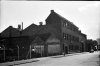
After studying some photo's. I think the building toward the centre of this photo is the place. If so then it was at the head of Pleasant Terrace and was at number 69 just up a little way from the school and that would fit in with what you say about following the school photos.
After studying some photo's. I think the building toward the centre of this photo is the place. If so then it was at the head of Pleasant Terrace and was at number 69 just up a little way from the school and that would fit in with what you say about following the school photos.
Attachments

Here are another two that have been on before (or possibly I only put one on). The old thread has gone, but we never determined for certain where this gasholder was . It appears to be incomplete, so presumably was being demolished. The pictures are between ones of a wedding and some of the Moseley St area, but are likely to have been taken on a different occasion than either.

