-
Welcome to this forum . We are a worldwide group with a common interest in Birmingham and its history. While here, please follow a few simple rules. We ask that you respect other members, thank those who have helped you and please keep your contributions on-topic with the thread.
We do hope you enjoy your visit. BHF Admin Team -
HI folks the server that hosts the site completely died including the Hdd's and backups.
Luckily i create an offsite backup once a week! this has now been restored so we have lost a few days posts.
im still fixing things at the moment so bear with me and im still working on all images 90% are fine the others im working on now
we are now using a backup solution
You are using an out of date browser. It may not display this or other websites correctly.
You should upgrade or use an alternative browser.
You should upgrade or use an alternative browser.
New unseen photos with no locations
- Thread starter Astoness
- Start date
Viewfinder
master brummie
I've looked at available aerial photos and also cannot find any houses near viaducts or embankments in that area.
Like others I'm reduced to looking at small details in the pics and they probably won't help ...
There are two terraces of only two houses at right angles to the road.
The houses have unusual small windows between the bedroom windows over their front doors . I can't recall previously seeing houses with that window layout.
The one terrace has the large building really close to it. The flat drained roof over the angled part of the building suggests there is a room underneath. Also the shadow on the right wall seems to indicate that the high wall finishes just out of shot.
There are out-houses with chimneys on the house gable ends adjacent to the road.
The houses have small front and back gardens and narrow access roads.
The houses have rooms each side of their front doors and so accomodation is not small and not cramped.
The street light in photo5 is different to the one in photo3 pics and could indicate a different road or even area.
OM - I think your original intuition that the location is more Small Heath than Cato Street North is proving to be correct. But I too have scoured your aerial photo and can't find a fit.
Presumably there are just two houses in the terrace, yet there are three pairs of chimney stacks: is the central pair shared between both properties? I'm also curious about that low extension with its own chimney; we have seen a similar thing in one of Mike's photos off Icknield Street. What do you think it was for? Structures like that were uncommon here in London.
Phil
Gone, but not forgotten.
Mike
Have you never been to the Watford Gap (Blue Boar) then?
If you remember when I first saw these photos I was pretty convinced that they were taken in Darwin Street Highgate at the rear of the Alhambra Cinema, but I have since consulted the maps and can see that it can't possibly be there. Though I am pleased to note that several contributors have formed the same idea as myself that the building in the background is a cinema.
The reason why I have not contributed any guesses or suggestions to this section of the thread is the same reason why I have not for some of the others. I am all guessed out. Which makes me especially pleased to see that you took the advice to post some of these untitled photo's so that others may take a stab at them. Thankfully some of them have been given locations and to be honest a couple of them I never thought would be.
The thing is they are out there now, and even if some of them prove difficult as it seems these two are then we may have a new member join sometime in the future who will know exactly where they are located and might even have lived there.
Viewfinder
master brummie
Mike
Have you never been to the Watford Gap (Blue Boar) then?
If you remember when I first saw these photos I was pretty convinced that they were taken in Darwin Street Highgate at the rear of the Alhambra Cinema, but I have since consulted the maps and can see that it can't possibly be there. Though I am pleased to note that several contributors have formed the same idea as myself that the building in the background is a cinema.
The reason why I have not contributed any guesses or suggestions to this section of the thread is the same reason why I have not for some of the others. I am all guessed out. Which makes me especially pleased to see that you took the advice to post some of these untitled photo's so that others may take a stab at them. Thankfully some of them have been given locations and to be honest a couple of them I never thought would be.
The thing is they are out there now, and even if some of them prove difficult as it seems these two are then we may have a new member join sometime in the future who will know exactly where they are located and might even have lived there.
Watford Gap (Northants) is a long way from Watford (Herts)! I've noticed on other threads that new or existing members contribute vital info to subjects sometimes years into dormancy. And of course it's terrific fun for us, lighting our pipes and donning our deerstalkers...
Phil
Gone, but not forgotten.
Watford Gap (Northants) is a long way from Watford (Herts)! I've noticed on other threads that new or existing members contribute vital info to subjects sometimes years into dormancy. And of course it's terrific fun for us, lighting our pipes and donning our deerstalkers...
Viewfinder
Having paid many a visit to the Blue Boar when it first opened in the 60's, and after four of us as young lads being questioned by the police sleeping in our car at Watford after a pretty raucous weekend in London. I did know the difference is about 50 miles or so in distance. I was just pulling Mikes leg, to be honest I would have thought that living down south as he does that there was more chance that he had visited Watford. There again I would have thought most teenagers in the 60's got themselves down to the Blue Boar at one time or another especially in the early hours of the morning.
Dennis Williams
Gone but not forgotten
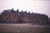
Help! This is a golden oldie...featured a few times in a variety of posts over the years...but I cannot remember it's true location! ...I THINK it was maybe old Ann Street....please confirm or deny....and the significance of the rather more ancient, almost church like remnants? Cheers....

Dennis Williams
Gone but not forgotten
Of course!! Now I remember it..! Cheers my friend! And I am still lurking mate.....albeit less frequently than usual.....old age.....
Phil
Gone, but not forgotten.
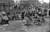
Whilst we are waiting for Mike to sort another one out (Mike could I suggest the Stores). I'll put this one up, I knew as soon as I saw it that it had been tagged wrongly because if this is any part of Calthorpe Park in the late 70's I will eat my hat. I thought it might be the seven streets adventure park that stood on Malvern Street off Clifton Rd where the inner city farm stands now, but even then it wouldn't fit. Any ideas will help?
Attachments

Agree Phil, not a park. Seems to be a demolition site, houses which have recently been demolished providing the wood for the climbing structure the kids are playing on. There's a pub in the background, maybe M&B and shops either side of it. So we're looking for a parade of shops ? Viv.
Last edited:
Viewfinder
master brummie
Viewfinder
Having paid many a visit to the Blue Boar when it first opened in the 60's, and after four of us as young lads being questioned by the police sleeping in our car at Watford after a pretty raucous weekend in London. I did know the difference is about 50 miles or so in distance. I was just pulling Mikes leg, to be honest I would have thought that living down south as he does that there was more chance that he had visited Watford. There again I would have thought most teenagers in the 60's got themselves down to the Blue Boar at one time or another especially in the early hours of the morning.
Sounds good! When I was at Aston Uni in the early 80s, a friend would occasionally drive us to London for the weekend. Mark was heavily into time-warped roadside architecture, and I recall us pootling along the A5 in his Hillman Minx: we stopped at the remains of the Blue Boar Café near Towcester. It had been demolished and was no more than a big pile of rubble, but Mark rummaged around and unearthed an old menu which he held triumphantly aloft: "Roast beef, 22p! Apple pie 8p! CUSTARD TWO PEE EXTRA!"
Phil
Gone, but not forgotten.
Agree Phil, not a park. Seems to be a demolition site, houses which have recently been demolished providing the wood for the climbing structure the kids are playing on. There's a pub in the background, maybe M&B and shops either side of it. So we're looking for a parade of shops ? Viv.
Viv.
During the 70's when they were demolishing parts of Balsall Heath lots of these adventure type playgrounds sprang up. They were usually run by student type people. I think we used to have someone on here who was responsible for running the one at Malvern St. I suppose the kids liked them and it kept the students from hanging around on street corners.
Looking across the road, the scene could possibly be the bottom of Balsall Heath Road on the old Speedway track, but I can see nothing that confirms that thought.
Looking at the photo from a purely demographic viewpoint, the children are predominantly Afro-Caribbean descent, with one white child and one child, I think, of Asian descent. As a very rough indicator of the local population this might narrow it down. Given that most of the children appear to be of Afro-Caribbean descent my first instinct was that this might be around Handsworth. Not a very scientific analysis, I know, just an observation.
And the boys look rather old to be playing on ropes, especially as one is dressed in a suit. It suggests to me this was a publicity photo or a photo to promote a cause perhaps. Viv.
And the boys look rather old to be playing on ropes, especially as one is dressed in a suit. It suggests to me this was a publicity photo or a photo to promote a cause perhaps. Viv.
Last edited:
Phil
Gone, but not forgotten.
Viv
The Ethnic mix that you point out was pretty much the same for Balsall Heath in the 70's as well. I'm pretty sure that it is in the vicinity of Balsall Heath because as I have said previously there were several of these types of temporary adventure parks in the area, just never one in Calthorpe Park as far as I can remember. Just why would they put one in a park that had facilities for children to play already.
This is the a similar park in Malvern St off Clifton Rd that I have mentioned already, this park eventually became an inner city children's farm, at first glance I thought it might be the same place but it's not for several reasons. The main one being that there were no shops opposite.
Attachments
Here is another unknown, taken on the same film as the 5 in post 410, but immediately after one of the Cato St North brewery, though it very likely may be nowhere near there. Immediately after it there are two unrecognizable shots of derelict buildings with no identifying features, and then one of Gooch St
There are two road nameplates which i cannot discern, but have enlarged that part of the photo in case it helps anyone else.


There are two road nameplates which i cannot discern, but have enlarged that part of the photo in case it helps anyone else.
Last edited:
Sorry Phil. That attribution seems to have got lost. So here are two others. They were on the film immediately after one of the corner of Hingeston st & George St West and one of a corner on Coralie St . I think the two are close, but the second has little in the way of identifying features, but the first , in the background has what looks like it might be a canal building where the roof goes over the canal


Viewfinder
master brummie
Mike what was you doing tramping around the old red light district with a camera in your hand, its the junction of Belgrave Rd and Alexandra Rd Balsall Heath. I thought I had already identified this for you at one time?
Mike likes to keep his balls in the air. The orange sphere in post #466 appears to be an inch or two above the pavement.
oldMohawk
gone but not forgotten
I was searching around for that modern looking 4 storey building with the pitched roof which shows behind the corner house and stands on the main road. Now Phil has identified the location I can see the 4 storey building on the GE 2001 view but not on the 2003 view. Presumably it was demolished between those dates and a patch of land is up for sale. The only building I can clearly identify is the low building in St Lukes Rd behind the 'Give Way' sign.Mike what was you doing tramping around the old red light district with a camera in your hand, its the junction of Belgrave Rd and Alexandra Rd Balsall Heath. I thought I had already identified this for you at one time?
Brookfields Lad
master brummie
Could the building with the pitched roof be the GWR buildings on Pitsford street?
Sorry Phil. That attribution seems to have got lost. So here are two others. They were on the film immediately after one of the corner of Hingeston st & George St West and one of a corner on Coralie St . I think the two are close, but the second has little in the way of identifying features, but the first , in the background has what looks like it might be a canal building where the roof goes over the canal
I think that that is the solution, and that the first photo is definitely the back of the building in the second photo. The (now unreadable) plaques above the alleyways in picture two show that these must lead to courts, which would originally been named or numbered on them., The position of the alleyways to the back courts, together with the closeness of the railway buildings, limits which houses it could be. I have concluded, and would welcome comments, that on the c1955 map below. the buildings illustrated must be either nos 149-155 (fronting court 31 and marked with a red line in front of them) or 145-151 (fronting court 29, and with blue line in front of them). I think 149-155 is the most likely as the rail buildings do seem quite close.

Hi mike to give you and others on the map and for a guide on what you are saying
Check the register for pick fords removal offices and there yard listing there number in Pitt Ford street what number of the office which was an house
In that period they kept there heavy iron fairys and cranes for lifting almost directly opersite there office (House ) they had a little yard next to the house for there vans
Which amounted to two it was mainly heavy liffting gear they kept with in the GWR. Yard behind the huge steel gates they had in those days
And it was also the delivery yard for the old GWR Delivery of parcels depot before changing to The BRS par el services and later moved to Rupert street
Nechells off rocky lane Aston when they had big green wagons and in those days at that depot
They Payed
20 quid a night shift for casual workers to load there big lorries day shift got less but you had to know some one whom was working there to get elected
For a job, Astonian,,,,,,,Alan,,,,,


oldMohawk
gone but not forgotten
Well spotted Carolina ...

I was looking in the same area on the 1939 view below but could not be sure whether the buildings I have marked as (2) had those sort of gable ends but your pic confirms they did. I'm now trying to work out from the aerial view where the house was in the first pic in post#469. The house seems fairly close to the gable ends.

I was looking in the same area on the 1939 view below but could not be sure whether the buildings I have marked as (2) had those sort of gable ends but your pic confirms they did. I'm now trying to work out from the aerial view where the house was in the first pic in post#469. The house seems fairly close to the gable ends.