• Welcome to this forum . We are a worldwide group with a common interest in Birmingham and its history. While here, please follow a few simple rules. We ask that you respect other members, thank those who have helped you and please keep your contributions on-topic with the thread.

    We do hope you enjoy your visit. BHF Admin Team

Maud Place, Garrison Lane

carlinwood

proper brummie kid
Hello,
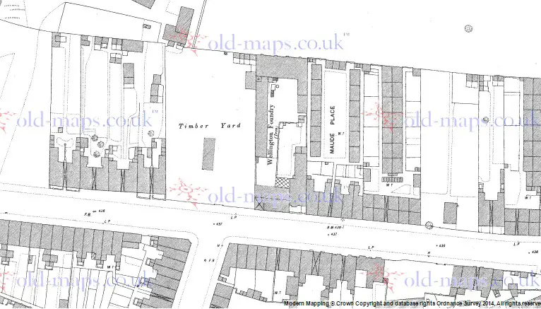
My Great Grandmother was born in "Maud Place" on Garrison Lane in 1888. Despite looking at the detailed 1:2500 Ordnance Survey map for that year, I can't find whereabouts it was. I can't find reference to it through the search function here either. Does anybody have any clues that might point me in the right direction as to what part of the street that might have been? The 1901 census shows them at No.4 at the back of 452 Garrison Lane. Could this have been it, and if so whereabouts on the street might it have been?

Any help would be greatly appreciated.

Best regards,
Carl
 
Hi Carl, It's often difficult to place exact addresses, the only way it can often be done is to work out approximately from trade or postal directories. the 1890 Kelley's shows A Millikan & Co, ironfounders at 446, then Mre sarah Russell, shopkeeper and Alex McKnight, varnishmaker at 448, then comes Atlas Road.
 
Thanks very much. Thats very good advice.I will take a look to see if I can pinpoint it from them. Strangely "Atlas Road" also seems to be missing as a cross street to Garrison Lane on the 1888 OS map. What were they drinking? ;)
 
Maud place is shown in red on the map below c 1951. Very few of the terraces and courts were named on the 1:2500 map, probably becuase there was not room to do so. It is named (though as Maude Place) on the 1:500 scale map. Atlas road later was changed to Doris Road

map_c_1951_part_garrison_lane_showing_maud_place.jpg
 
Thank you for the map Mikejee. That makes it very clear indeed. I had pictured them being further up the lane towards Wolseley Street where they had moved to in a later census. I will have to look out for the 1:500 scale map as that sounds like a great asset to have. Cheers all.
 
The 1:500 map is now , for Birmingham,, only available on the oldmaps site, though you now have to have a subscription or buy the map of the relevent area from them to see it with the relevant detail. It is, of course freely available to view at the Birmingham Central libraries.
 
Thats a shame. I think £120 a year for access to the map might be hard to justify. Thanks again for the info.
 
If mikes colourd section on the map is right, it looks to me they must have been demolished it to make room for ‘Raggy Allan’s scrap yard, it fits in with the address 452 Garrison Lane

Nick
 
Here is the relevant part of the 1:500 c1889 map. If there are a lot of maps you want to access then you need only pay for one month and do all at the same time . Many people do that with genealogical sites.

map_c_1889_showing_maude_place2C_garrison_lane.jpg
 
Thanks Nick and Mike. That would work out a lot cheaper. I hadn't realised that you could cancel 1 month in. Its £11 for just a small square as a PDF so that works out much better.

Raggie Allen looks right. I'm also wondering whether the 'back' houses shown on many sites as being of Garrison Lane could be Maud place or, if not, very similar in design. I'm not seeing many backs down the lane in the maps I've seen.
The other thing that strikes me is that the saw mill shown in the first map is roughly where part of HM Lowe and Sons Timber yard exists today. We talk about what has been lost often, but that seems a remarkable length of time for continuity and a real echo to the past..
 
Back
Top