• Welcome to this forum . We are a worldwide group with a common interest in Birmingham and its history. While here, please follow a few simple rules. We ask that you respect other members, thank those who have helped you and please keep your contributions on-topic with the thread.

    We do hope you enjoy your visit. BHF Admin Team
  • HI folks the server that hosts the site completely died including the Hdd's and backups.
    Luckily i create an offsite backup once a week! this has now been restored so we have lost a few days posts.
    im still fixing things at the moment so bear with me and im still working on all images 90% are fine the others im working on now
    we are now using a backup solution

Martineau Street

Vivienne14

Kentish Brummie Moderator
Staff member
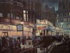
Martineau Street no longer exists and surprisingly didn't have a particularly long life.It was cut in 1886 to replace Crooked Lane. But by 1960 it had disappeared as part of the development of Martineau Place. Martineau Street looks to have once been a significant street, with many substantial buildings.


a9y3ybes.jpg
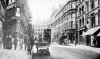
Martineau Street in 1903

dazehysa.jpg
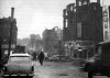
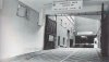
Martineau Street to the right, Rackham's development to the left in 1959

u5u5uduz.jpg
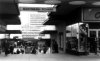
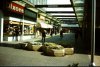
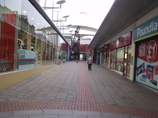
from the 1977 Archaeological Desk Survey for the development of Martineau Galleries by Litherland and Mould.


Viv.
 
A photo of the end of Martineau Street that looks more like it was taken in 1943 instead of the real date of 1963 given with the photo.
 

Attachments

  • City Martineau St 1963.JPG
    City Martineau St 1963.JPG
    136.2 KB · Views: 133
Certainly does Phil. Never particularly liked what replaced it. The Litherland/Mould extract says "In Martineau Square this route opens out onto an attractive resting-place". Well, not the one I remember. Viv.
 
Viv, What possible comparison could there be between this first photo and the second two. The first one shows architecture and the second two a series of boxes. Why were the planners allowed to get away with it, and what is more they are still being allowed to.
 

Attachments

  • City Martineau St Nr Crooked Lane.JPG
    City Martineau St Nr Crooked Lane.JPG
    196.7 KB · Views: 125
  • City Martineau Square.jpg
    City Martineau Square.jpg
    60.4 KB · Views: 113
  • City Martineau Way.jpg
    City Martineau Way.jpg
    92.8 KB · Views: 102
Strictly speaking Martineau Street and Crooked Lane existed at the same time according to this 1890 OS map. Looks like Martineau Street only replaced Crooked Lane in the sense of it being as a more direct 'route' to High Street/Dale End. So Crooked Lane remained after Martineau Street was cut through, but don't know exactly how long after though. Viv.

enudydat.jpg
 
The Martineau Square architecture just looks so unfinished Phil. I know many people wanted 'modern' by this time, but it looks, well, boring. All the interesting character gone, along with all the quality shops and offices.

And Crooked Lane was still well and truly there in 1946 according to this extract from The Inner Ring Road development map. Viv.

9e6yhu3u.jpg
 
I think this is how I remember Martineua street, its a print by Robert Calvert, called Trams At Night.
 

Attachments

  • Martineau.JPG
    Martineau.JPG
    314.6 KB · Views: 116
A great print Nick, full of atmosphere. Can make out the Cobden on Corporation Street/corner of Cherry Street too.. Wonder what 'Abdulla' was? Viv.
 
Thanks all. Those businesses must have done a roaring trade right next to the tram stop. I like the little boy waiting for the tram holding a wrapped gift. Maybe he went into town with his grandpa to buy it and can't wait to get it home! Viv.
 
A modern view of what is now Martineau Way.


Note that Poundland has moved to where H & M used to be. And Argos now occupies the former Dixons location.
 
Thanks Ell. It's changed a little, but not so much as to call it an attractive shopping area. Still has a slight air of 'no-mans' land about it!

Now if I remember rightly, the Martineau Square development started alongside and parallel with Union Street. But does anyone know how far it stretched towards Bull Street. Martineau Street was between Union Street and Bull Street. So did the Martineau Square development cover the whole area between Union and Bull Streets I.e covering over and stretching beyond Martineau Street? Viv.
 
Thanks Richie. I'm presuming the John Ball photo is of the bottom end of Martineau Street (Dale End/High Street end) actually looks like very little of Martineau Street left at that time. And there seems to be an entrance to a car park (?) there perhaps. Would this be underneath the Martineau Square development ? Viv.
 
Thats a yes to everything Viv. For those with a little time, there's a photo of Henry's department store-or rather its plot of land-which should pick up Martineau Street in around 1960 also. Just can't find the right thread it appears on.
 
Is a bit odd having an office block in the middle of restaurants and take aways, that is below it (although many Martineau Place units are still empty!).

Snow Hill Plaza / JFK is now a Holiday Inn Express.

Exchange Buildings near New Street is now a Premier Inn.
 
A later rendition of the photo at #14 which was in fact the entrance to the underground loading bay for what was then known as Commercial Union House. Which was laid out on the line of Martineau Street. The actual entrance has been changed again since this photo.
 

Attachments

  • City High St Commercial Union Loading Bay on the line of Martineau St.jpg
    City High St Commercial Union Loading Bay on the line of Martineau St.jpg
    152.3 KB · Views: 54
Think many buildings are these days adapted to meet demand. So turning unoccupied buildings into hotels is as good a use as any provided you've got the customers to fill them and pay for them. All helps the local economy.

Wonder why the Commercial Union needed such a big loading bay? Surely an insurance company doesn't need a massive underground loading bay? For what? Paper? Don't get it. Viv.
 
Viv, These underground service tunnels often served more than one outlet and then there was private parking for the higher ups. The entrance for the Big Top site where the tax offices were was in Moor St. I think it's still there today and that was a massive underground complex that went under the High Street.
 
Viv, These underground service tunnels often served more than one outlet and then there was private parking for the higher ups. The entrance for the Big Top site where the tax offices were was in Moor St. I think it's still there today and that was a massive underground complex that went under the High Street.

Thanks Phil. Always find these underground structures fascinating. And they're right there under our feet as we go to and fro in the streets above. Maybe the service tunnel burrowed through the cellars of the Victorian houses then if it followed the route of Martineau Street. Viv.
 
Even night lighting didn't do much to improve the atmosphere of Martineau Square. Still looked unfinished to me. Viv.

ude8a8ap.jpg
 
Even night lighting didn't do much to improve the atmosphere of Martineau Square. Still looked unfinished to me. Viv.


ude8a8ap.jpg

Some years ago I bought a TV from this Dixons shop. I had to drive my car into the tunnel entrance at the High Street/Bull Street junction to get to their pick up point underneath the shop.There seemed to be a lot of other tunnels running off this one,fascinating !
icon7.png
 
This is the one Bernie. Found it in my collection. Comes from one of the Alton Douglas publications, view dated 1958

martineau 001.jpg
 
Back
Top