• Welcome to this forum . We are a worldwide group with a common interest in Birmingham and its history. While here, please follow a few simple rules. We ask that you respect other members, thank those who have helped you and please keep your contributions on-topic with the thread.

    We do hope you enjoy your visit. BHF Admin Team
  • HI folks the server that hosts the site completely died including the Hdd's and backups.
    Luckily i create an offsite backup once a week! this has now been restored so we have lost a few days posts.
    im still fixing things at the moment so bear with me and im still working on all images 90% are fine the others im working on now
    we are now using a backup solution

Mansfield Road Aston

The Milky Bar Kid

proper brummie kid
Hello all

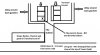
I am trying to find out the location of my first childhood home. Asking a lot but it was in Aston not far from Tower Road (possibly 3 - 5 streets away) I always knew at as the gully, as the houses (terraced) where set back from the road and accessed from an short unsurfaced road. I have attached a rough sketch of the general location, if anyone recognises the area, I would much appreciate a road name or some images of the gully :)


~
 

Attachments

  • Unknown road.jpg
    Unknown road.jpg
    88.3 KB · Views: 47
HI MILKY BAR KID
Do you have an addrees code for that house if you can recall meaning had you gt an house number
it was situated on would be a big clue
I Have only one gully in mind as an aston lad , I do not recall anyaround the top end of tower road
hope you can come up with some think best wishes Astonian ,,,,
 
This is a guess based on looking at old maps near to Tower Road but Bridge Street West looks as if it has some houses situated as you mention. That is 4 streets up from Tower street.

Janice
 
This is a guess based on looking at old maps near to Tower Street but Bridge Street West looks as if it has some houses situated as you mention. That is 4 streets up from Tower street.

Janice

Hi Janice

Just been looking at some maps online based on your information and my memory was jogged/kick started .. We actually lived at the back of Mansfield Road. I remember having a great time chasing around the alleyways. I recall having a plastic Werewolf mask (I actually wanted a Herman Munster mask!) and using it to terrify a girl we knew as bootsie, whose mum was a friend of my mum and was not amused.
 
Last edited by a moderator:
welcome milky bar kid...tower road was off potters hill aston...tower st was in newtown..do you have your birth cert to say where you were born as this could be difficult to pin down and what years were you living in this street for

lyn
 
Last edited:
Hi Janice

Just been looking at some maps online based on your information and my memory was jogged/kick started .. We actually lived at the back of Mansfield Road. I remember having a great time chasing around the alleyways. I recall having a plastic Werewolf mask (I actually wanted a Herman Munster mask!) and using it to terrify a girl we knew as bootsie, whose mum was a friend of my mum and was not amused.

i will try and post a map of the area for you...something may jog your memory
 
welcome milky bar kid...tower road was off potters hill aston...tower st was in newtown..do you have your birth cert to say where you were born as this could be difficult to pin down and what years were you living in this street for

lyn

I was born on February 1959 and lived at my grandmothers house (Mrs Sheargold - she had a shop that sold novelties on Potters Hill) in Tower Road until we moved to Mansfield Road around 1962/63
 
Last edited by a moderator:
hi milky bar kid i am a little confused now (not difficult) so are you now saying that you have solved the mystery of where you lived as a child and that it was mansfield road ??

lyn
 
The electoral roll needs an address - but a Violet Sheargold with a Frank Sheargold are there at 110 Tower Road up to 1955 when the online records cease. In fact there is an Annie and a Henry in 1922 as well. Frank appears in 1925 as far as I can tell.

Janice
 
I lived in Tower Road dont recall any alleys,if you went up the entries at the back were houses and gardens i remember the Sheargolds
 
Just after the transcribed dates on ancestry unfortunately. However, as you know the general are it shouldn't be too difficult to find them on the electoral rolls if you can get to the new library.
 
YES LYNN

I THOUGHT THAT LAST NIGHT BUT I WAS NOT ONE HUNDRED PERCENT ABOUT POTTERS HILL
AND THIS GULLY WAY COMING THROUGH WOULD HAVEBROUGHT YOU THROUGH ABOUT
THREE PARTS OF THE ROAD AT THE TOP END OF POTTERS AS I VAGUELY RECALL
WHEN I USED TO ROAM AROUND THE AREA AS A NIPPER AND WALKED TOWARDS VICTORIA ROAD
AND TURN RIGHT HEADING BACK DOWN THE LICHFIELD ROAD TURNING RIGHT AGAIN
AND TURNING ON TO PARK ROAD BY BUCKINGHAMS THE CHEMIST CROSSING THE TRAFFIC LIGHTS STILL HEAD
HEADING ALONG THE PARK ROAD AND DOWN UPPER PORTLAND STREET DOWN TO MATTYS RADIO AND T V SHOP
JUST LEFT THERE AND I WAS BACK HOME ALAN,,,, Astonian,,,,,
 
Violet and Frank Sheargold were still living at 110 Tower Road in 1965 ,i found Dorothy and William Dodson living in Mansfield Road in 1965 couldnt find them in Mansfield Road before that
 
Hi Milkybar kid Your dad was my Uncle Bill my Mothers Brother. My Mother was Evelyn Dodson. they lived at 10 Frederick road Erdington, that was their home, which is where I grew up, with Gran. I used to give your Dad driving lessons in his work Ford Thames van.
 
Hi Robert, thank you so much for the pictures of mum and dad, I have forwarded them to my brothers Michael and Robert.

It was interesting to find out Nan Dodson's actual address in Erdington too before she moved to Shard End and not far from were we used to live in Kingshurst (we used to visit nan quite regulary)

I did a search on google maps to see if I could find the house and its still there I think, I seem to remember it was quite a big house.


10.jpg
 
Yes that is the house (the white one with the caravan). Your Dad, me and Cousin James had our bedroom in the back attic to the rear of the attic room you see at the front. We attended Slade road School. Your Dad worked at a builders/plumbers on the corner of Frederick road just to the right of the house. long since gone.
 
I know Dad worked for Harry Lewis plumbers and for a couple of years we went to Wales on our hols in the Bedford plumbers van. Dad used to sweep it out and lay down boards so that we sleep in it. Don't think we ever stayed at a proper camp site, it was always a farmers field with stand pipe nearby. Around 1968 onwards, Harry Lewis retired and Dad took over his business and customers.
 
I would like to find an old friend, i lost track of him about 1966 when we moved from Albert Rd, Mansfield Rd End, to Newtown. The front of there house was on Witton Rd but you could open wide gates onto Mansfield Rd . His Name Was John Hanlon , ( Handlon ? ) I think he had two sisters one called Marie i think. John would have been born Between 1956 - 58. If i remember right he went to St Chads School . I would love to know what happened to the family after the area was redeveloped. Thank you for any information you can give , The family was Like My family to me.
 
There's a Charles & Eileen Mary Hanlon listed at 102 Witton Road on the ERs in the late 50s and 60s. From the map it appears that it backs on to Mansfield Road. They seem to have had 3 children - Margaret M (1955), John A (1957) and Julia M (1959).

Also in Bham there is a birth registration for a John F Hanlon (1957) and a John T Hanlon (1958).
Thats amazing, Iv been searching years. Is there anyway of telling were they moved to? It has to be the right family as i remember the mom Eileen and Julia. Thank you so much.
 
Unfortunately, the last online electoral rolls (on Ancestry) are 1965 and it is virtually impossible to search for a person using the ERs at the library.

A John A Hanlon married a Janet L Travers in 1982 but there's no guarantee it's him. The only thing I'd be fairly confident in after 1965 is that Eileen died in 1987.

Facebook and the like might be your best option.
Thank you for finding out so much for i am very grateful and will continue looking .
 
I know Dad worked for Harry Lewis plumbers and for a couple of years we went to Wales on our hols in the Bedford plumbers van. Dad used to sweep it out and lay down boards so that we sleep in it. Don't think we ever stayed at a proper camp site, it was always a farmers field with stand pipe nearby. Around 1968 onwards, Harry Lewis retired and Dad took over his business and customers.
Hi

Am I correct in thinking you are after your first childhood home? Because there is a lot of talk about Mansfield Road, which correct me if I'm wrong, was your second.

Your sketch looks very much like "The Retreat" to me; which was the continuation of the short end of Sutton Street.
For certain there was no road surface there. I spent quite a bit of time on the "bomb site" as we used to call them; when people had left the area. There was a rope swing attached to a tree we used to play on.

See picture below.
I always wondered why the short part of Sutton Street was not called Upper Sutton Street.
The picture you posted, a while back (Tower Road thread) of your Nan walking down Tower Road with a toddler; was heading in that general direction too.
I can't admit to the shops though. I think they could possibly have been the first to be demolished.
There was a nameplate for the gulley; as I said "The Retreat" but it doesn't appear on any maps of the area that I have seen.

1623415173744.png
 
Here's a map from 1951. The house numbers seem to imply that the bit of the road you highlighted was part of Sutton St, the Retreat a little lower down.

Sutton Street.jpg
 
Back
Top