• Welcome to this forum . We are a worldwide group with a common interest in Birmingham and its history. While here, please follow a few simple rules. We ask that you respect other members, thank those who have helped you and please keep your contributions on-topic with the thread.

    We do hope you enjoy your visit. BHF Admin Team
  • HI folks the server that hosts the site completely died including the Hdd's and backups.
    Luckily i create an offsite backup once a week! this has now been restored so we have lost a few days posts.
    im still fixing things at the moment so bear with me and im still working on all images 90% are fine the others im working on now
    we are now using a backup solution

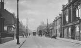
Lozells Road, Shops, Pubs, Businesses etc

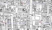
nice one viv...here is a map showing its location...i would say roughly where archibald road is now...in between burbury st and lozells st..map dated 1860

View attachment 109852
Hi Lyn, sorry for going off thread. I can't quite make it out but, does the map say "school" where Gower St is? This map is 2 years before the proper school was established and I'm sure this was the temporary building.
 
hi barry tad confused as the link you posted takes me to the map i posted showing where lozells farm was can you confirm

lyn
 
hi barry tad confused as the link you posted takes me to the map i posted showing where lozells farm was can you confirm

lyn
Lyn, sorry about the confusion. I was looking through the Lozells Rd thread when I noticed that map you posted showing where Lozells Farm was. I also noticed on the map a word which looked like 'school' in Gower St. Because of the low resolution I couldn't quite make out if it did say 'school'. I just wondered if you had a clearer image and could verify there is a school there.
 
Here's one for those of us over seventy....Anyone remember the Dentist....Mr. WIDDOWSON! OMG! He scared me to death, he had hands like huge hams, and gave me nightmares. His surgery was somewhere at the top, near Heathfield Road. Gerry
Just reading this Gerry, my dad used to go to him for his dentist work. I went once and never went back, it was like being in a horror movie!
 
Lyn, sorry about the confusion. I was looking through the Lozells Rd thread when I noticed that map you posted showing where Lozells Farm was. I also noticed on the map a word which looked like 'school' in Gower St. Because of the low resolution I couldn't quite make out if it did say 'school'. I just wondered if you had a clearer image and could verify there is a school there.
no probs barry does not take much to confuse me....sorry i cant make out if it says school

lyn
 
Around 1962 I remember a shop called something like M & J which sold fashion clothes for us dedicated followers of fashion. Bought my shortie raincoat from there. It was situated in one of the shops opposite Hartington Rd.
Bought my first suit there in 1962 !
Always liked the place.
 
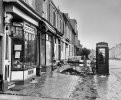
Here are some photos of the Lozells Road area which Keith Berry took in 1979.
View attachment 147576
View attachment 147577View attachment 147578View attachment 147579View attachment 147580View attachment 147581View attachment 147581View attachment 147582View attachment 147583View attachment 147584View attachment 147585View attachment 147586View attachment 147587View attachment 147588View attachment 147589View attachment 147590View attachment 147591View attachment 147592View attachment 147593
They are from pdf4 in link below

aThird photo up ,
I rember this one on corner of Chain walk , in the late 50s was a coffee shop italian , lovely looking young lady about my age of 12 Lived there , my elder brothers best mate lived in the walk , i used to ferry messages between them from our house in Paddington street....good earnings , but a lomng run up the three gulleys
On the left bottom corner of photo is part of Gower st school
 
As a child I can remember Lozells Road very well. This was in the 1970's/80's. A very different place to now. We had a Woolworths (where I bought my very first record), Fine Fare, Boots The Chemist, A Wool Shop (cannot remember the name), a Pet Shop. At the far end there was The House of Holland. There was Wilkinsons at the other end of Lozells Road, probably Villa Road. As for pubs there was the Lozells Inn and was it the Bell Inn and of course The Royal Oak.

Has anyone got a photographs of Lozells Road around this time. I have seen more upto date ones of Lozells Road as it is now and it has considereably changed from when I was a girl.

There was also a petrol station and a newsagents inbetween Carpenters Road and Burbury Street.

Further along towards Villa Road was also Price and Olivers and a shop that used to sell pens. This may have been Price & Olivers or something else. There was also a pet shop I think at the corner of Berner's Street.

If anyone could fill in the gaps as I know there were lots more.
I remember McGauleys toys and pram shop.
 
Can you give a date when this happened only I was told on the day I was born there was a bombing raid? 14/08/1942.
according to the BARRA site

Lionel William Jennings was killed on the 28 July 1942 at Lozells Cinema, Lozells road. Lionel was 49 years of age when this happened.
 
according to the BARRA site

Lionel William Jennings was killed on the 28 July 1942 at Lozells Cinema, Lozells road. Lionel was 49 years of age when this happened.
Hi
Just checked air raids over Lozells and read that the raid was on 16/08/1942? Given by resident of Gerard street (WW2 People’s War Diana Purcell. and Bill Jones.)
 
Last edited:
My great aunt and her family lived at 39a John st Lozells during the war. They used to go over to my Nan's in Sutton Coldfield to escape the bombing. They were Charlie, Cis, Rene and Dougie Bradley.
 
Lyn

The name of the Manager that was killed in the raid that destroyed the cinema in 1942 was Lionel Jennings, he was on fire watch duty at the time.

Phil
Lyn

The name of the Manager that was killed in the raid that destroyed the cinema in 1942 was Lionel Jennings, he was on fire watch duty at the time.

Phil
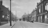
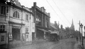
the photo you posted is not the same Lozells picture House that was bombed in WW2. Your posted photo is of the original Lozells Picture Palace/House situated opposite William Streeet and next door to the Co-op and a few doors from the Bank on the corner of Lozells Road and Birchfield Road. St Pauls church in the distance on the right, show how near this Lozells picture house was to Six Ways Aston. There are a couple photos available of the bombed cinema built on the corner of Wilton Street and Lozells Road, if I find them I will post.
 

Attachments

  • lozells road1915.jpg
    lozells road1915.jpg
    23.8 KB · Views: 39
well i never knew that kath..i always thought the photo phil posted and the one you have just posted was the cinema that was bombed...i didnt know there was another cinema on the corner of wilton st and lozells road i thought there was a rollar rink on that corner...

lyn
 
Last edited:
thanks for the maps jan i do have them somewhere but does confirm that cath and phils photos are of the picture house on lozells road that was bombed...as far as i know we have no photos as yet of the picture theatre that was in wilton st
 
The two links I posted are to the 2 different buildings one which fronted Lozells Road and one which seems to be set back. If you click on "overview" you get a potted history.
 
Last edited:
The two links I posted are to the 2 different buildings one which fronted Lozells Road and one whihc seems to be set back. If you click on "overview" you get a potted history.
yes thanks jan i know that..my point was that my understanding was that the cinema that was bombed killing the manager was neither of those shown in your maps....i am pretty certain the one that was bombed was actually on the lozells road just up from st pauls church...here is a photo of it which also shows the church just a tad further down


Lozells Lozells Picture House Bombed 1942   (1).jpg
 
Last edited:
Might not be on the map as I could not find another cinema marked apart from those 2.
However one of the links I posted is to the picture you have posted. (The picture theatre was bombed). Think it even tells you what shops are there now.
 
Last edited:
Might not be on the map as I could not find another cinema marked apart from those 2.
However one of the links I posted is to the picture you have posted.
thanks jan...it can be confusing having 2 cinemas so close to each other...posted this before but i remember mom telling me that she one of her class mates at lozells girl school was the daughter of the manager who was killed and something was said about it in assembly

lyn
 
I am getting myself confused but one is 54 and the other 56 Lozells Road and the write up on the Theatre states the manager was killed. That is the one on the 1938 map.
So I don't know where any other cinema was.
 
yes mike we have done this before...this pic shows the a cinema on the main lozells road next to the co op its looking towards villa road...mike could you check what number the co op was at please..it is odd that i cant find a map showing it

lozells road1915.jpg
 
Back
Top