• Welcome to this forum . We are a worldwide group with a common interest in Birmingham and its history. While here, please follow a few simple rules. We ask that you respect other members, thank those who have helped you and please keep your contributions on-topic with the thread.

    We do hope you enjoy your visit. BHF Admin Team

Long Acre

F

Forward

Guest
Any info, maps, photos please on:

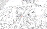
Long Acre, circa 50's?

Cottage Houses in Long Acre, not far past where Black & Decker was?

Also rail goods sheds?

Ray
 
Hi Forward

These are the only photos of Long Acre that I have

The Junction Stores Outdoor
Newman's Boot & Shoe Makers.
The Prince of Wales Public House.
The Methodist Church close to Railway Terrace.

Phil

Lost photos replaced by same as the original ones

Nechells Long Acre Prince of Wales.jpgNechells Long Acre Junction Stores Outdoor.jpgNechells Long Acre Nechells.jpgNechells Long Acre Railway terrace.jpg
 
Last edited by a moderator:
Hi Phil,

Thank you for the photo's. I will show to folks and see what memories are stirred.

Ray
 
Hi Forward

These are the only photos of Long Acre that I have

1. The Junction Stores Outdoor
2. Newman's Boot & Shoe Makers.
3. The Prince of Wales Public House.
4. The Methodist Church close to Railway Terrace.

Phil


hi phil..i wonder if you could re post the above pics please as we seem to have lost them in the upgrade... any other pics of longacre would be appreciated including the white horse pub...

many thanks phil...

lyn
 
Lyn

I have reposted them back on the original post, and this is another one that I didn't have at the time. It's the Royal Exchange on the corner of Rocky Lanr & Long Acre.

Phil

Lost photo replaced by photo I believe i same as original

Nechells Royal Exchange Rocky Lane - Long Acre.JPG
 
Last edited by a moderator:
many thanks phil...i will look out for a pic of the white horse pub long acre...but if you havnt got one it may prove difficult....

lyn
 
Brilliant photo Phil, on the opposite corner was barber Brown where I used to get my hair cut as a nipper, he used to sit outside during slack periods in the summer and play the banjo.
 
thanks for that pic john....ive just noticed that longacre no longer meets rocky lane

lyn
 
Lyn, it did end at CromwellStreet.
As far as I know there was no White Hart in Long Acre, there was one at 41 Cromwell Street and one in Nechells Park Road about no. 7.
John.
 
Lyn, it did end at CromwellStreet.
As far as I know there was no White Hart in Long Acre, there was one at 41 Cromwell Street and one in Nechells Park Road about no. 7.
John.

john its the white horse pub i am looking for not the white hart..was on the corner of longacre and holborn hill..demolished in the 70s....
 
thats ok john im only just waking up myself lol...thanks for the landlord info..will write that down...
 
Lyn

I don't think the pub was quite on the corner, as can be seen from this extract from the 1950's edition of Kelly's.

Phil


HOLBORN
HILL, 308
Nechells Park road to
Thimble Mill lane & Lichf


ield
road. MAPJ2.
Nos. 1 to 75 are in postal
district 7 & 76 to 116 are
in postal district 6.)
SOUTH-WEST SIDE.
here are Cumberland bldgs
3, 4, 5 & 8 Tippett S. R. &
Go. Ltd. shipping agts.
(warehouse)
35 Trow Geo. bldr. (yard)
75 White Horse P.H. Horace
Masters
97 City Printing & Paper
Co. printers
here is Long acre

.. here is Thimble Mill la ...

 
Lyn
the Kellys must have a glip. here is an 1889 map showing White horse is on corner
mike

mapc1889juncholbornhilllongacreshowingwhitehorse.jpg
 
Mike

As you say it must be an error in that edition of Kelly's as I have looked before (1937) at it was No 75 on the corner and after (1967) it was again No 75 on the corner.

Phil
 
This is for JPSmyth, the map shows No. 41 Long Acre (formerly 381 before renumbering).

No. 15 (1881) would most likely be No. 56 on this map.
 

Attachments

  • 41-long-acre-map.jpg
    41-long-acre-map.jpg
    716.9 KB · Views: 10
Last edited:
It appears that sometime after the 1881 census and before the birth of Caroline Jane, that William and Charlotte moved to No. 15 (including William's father). They're not there on the 1891 census as far as I can see.
There are more proficient people on BHF who may be able to sort this out for you.
 
Following a request on another thread:
Below is a map of part of Long acre. the red buildings are definitely the numbers given, and , from this, I am pretty sure the blue marked building is no 86. Will also post this on the Long Acre thread.

map 1880sm showing 86  Long Acre.jpg
 
Back
Top