• Welcome to this forum . We are a worldwide group with a common interest in Birmingham and its history. While here, please follow a few simple rules. We ask that you respect other members, thank those who have helped you and please keep your contributions on-topic with the thread.

    We do hope you enjoy your visit. BHF Admin Team
  • HI folks the server that hosts the site completely died including the Hdd's and backups.
    Luckily i create an offsite backup once a week! this has now been restored so we have lost a few days posts.
    im still fixing things at the moment so bear with me and im still working on all images 90% are fine the others im working on now
    we are now using a backup solution

Location wanted for this bus if possible

Status
Not open for further replies.
I don't think it would add to the debate. Might cause more speculation. :grinning: The bus (same type as post 1# CVP 196) is the main feature with another bus (side only) at the rear. The only building is a small part of the Sun Inn seen, on the left but at the right hand side of the bus.
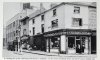
The text actually mentions the boot and shoe repairer of Horace Baxter, seen on the right, but it is not there, the photo is clipped.
Another picture, on the same page, shows two trams on Bristol Street and mentions the junction with Sun Street and the text states 'where the Inner Circle crossed Bristol Street from Sun Street to St. Like's Road'.
Part of the Sun Inn is seen on the left. No photographic value really except to confirm the route of the 8 bus route in 1951 and 1959/60.
 
Last edited:
Although many features on the Sunday School building match features in the original bus pic, chimney pot and tower above the bus and other as mentioned in post#196, there is one thing that has been nagging at me and it is the open space above the car and lorry as enhanced and highlighted in the pic below. The tall street lamp shows up against open sky. It could be that buildings have been demolished. I have not yet been able to find any old pics of the north corner of Sun Street and Bristol Street.
That No 8 Bus.jpeg
 
Extract from page 39 confirms the bus route in St Luke's Road (permanent or temporary?). Adds to confirmation of the building in my opinion. John
 

Attachments

  • page39.jpg
    page39.jpg
    1.1 MB · Views: 26
Extract from page 39 confirms the bus route in St Luke's Road (permanent or temporary?). Adds to confirmation of the building in my opinion. John
Well it is clear that the Inner Circle buses where crossing the Bristol Road from Sun Street into St Lukes Road and would have gone past the Sunday School in 1959. Also it appears that R.F.Mack was taking photographs in that area. We need a photo of Horace Baxters shop to compare it with the shop in the post#1 pic.
 
The original photo appears to have a tall pole type street light with lamp on an arm, St. Luke's Road and Sun Street were not major roads and had ordinary street lighting it seems.
The road surface in the photo on p.39 (post 243) looks different.
All the photos here are of the Baptist church at an earlier date and as such the building may have had alterations by 1959. It seems by that time the church was disused and due for imminent demolition.
Robert F. Mack took photos transport in many places, not just Birmingham. He also wrote a couple of books.

As I pointed out previously there is a lamp poking out on the LHS on post 224, opposite the Wycliffe Church. This seems similar to the one on the RHS of the very first picture.
 
The original photo appears to have a tall pole type street light with lamp on an arm, St. Luke's Road and Sun Street were not major roads and had ordinary street lighting it seems.
The road surface in the photo on p.39 (post 243) looks different.
All the photos here are of the Baptist church at an earlier date and as such the building may have had alterations by 1959. It seems by that time the church was disused and due for imminent demolition.
Robert F. Mack took photos transport in many places, not just Birmingham. He also wrote a couple of books.
post 224 is showing lamp posts with an arm and further down the road too
 
Trams ran further down the road until 1949, that would need tall poles but not necessarily with lights. The trams photos in St. Luke's Road show only poles and overhead. My view would be at the junction is is likely that a tall pole and light would be sited. St. Luke's Road was not a very wide road, the tram track was a single line.
Incidentally the No.8 route diversions, in that area, started around 1962, probably when the church and other buildings were under demolition.
 
In both the pictures the tall lamp would be near the junction with the main Bristol Street, and opposite the spire. The spire was taken down before the demolition, but was still standing March 1960.
 
Last edited:
Well it is clear that the Inner Circle buses where crossing the Bristol Road from Sun Street into St Lukes Road and would have gone past the Sunday School in 1959. Also it appears that R.F.Mack was taking photographs in that area. We need a photo of Horace Baxters shop to compare it with the shop in the post#1 pic.

Yes. It is the only corner of the crossroads that we are missing.
 
Yes. It is the only corner of the crossroads that we are missing.
Yes, I suppose the other three corners were more interesting with two churches and a pub. If a pic of the missing corner was available I would be looking for a small bay window on the first floor as seen in the pic in #242. Later I might have a look through the two hour long trams film in the 'Electric Trams' thread and see if it showed that part of Bristol St/Rd.
 
C76EA9B1-8005-4E1C-93BB-E9AF61638111.jpeg46E1EFFD-C7B2-405A-8822-9481B0F7E953.jpeg

I suppose without a picture of the old Sunday school and its windows, also one of Baxter s Shoe shop the mystery will remain unsolved . Even then someone will have doubts.
There is a poor picture of the statue of Wycliffe himself from 1954. The other picture shows how confused the Birmingham Daily Post can get. A picture of the demolition of St Luke’s Church in 1961.
 
Although the location of the bus has not been found the Thread has led to a trip around the Inner Circle route and its diversions of the 50s and 60s. A look at the impressive Spring Hill Library and its architecture that is still with us, also that of St Luke's Church and the Wycliffe Baptist Church that have both gone.

Then a look at parts of Sun Street an St Luke’s Road that have now disappeared, the history of the actual bus and accounts of a few bus crashes.
As a matter of interest are there any that now believe it is Spring Hill Library?
 
Banjo,When we used to catch the number 8 at the top of Belgrave Road nearly every Sunday morning as kids and ride round the whole route in the early 50's. The route we took was Belgrave Road to Bristol Road where it crossed over into Spring Vale, we then turned right into Spring Street and left into Sun Street West and straight on up Lee Bank Road.
Hi Phil, my recollection of the No8 turning into Pershore Rd (Sherlock St) from Belgrave Rd would have been around 1957-8 so, a bit later than when you rode it. Perhaps the Belgrave development in Spring St had already started then so could explain the diversion. Could the bus shelter in the photo have originally been for a different service? P.S Since the above posting, I've just found tardebigge's comment on the No 8 Bus Route thread (#62) which confirms my assumption about the bundy clock in Pershore Rd/Sherlock St. Barry (Banjo)
 
Last edited:
Wellpedrocut yes there is many of uswhom are correctly right in maintaing that is personaly and know its springhil
Andfor myself growing up on the springhil as a kid on the block and roaded the eight bus every sunday around the circle for a tanner there was six of us kids went round both ways month in and month out during the school holidays knowing the shops along there blinded folde d race and walked thoose slabs daily and witness every bus accidents of the years And seen the alterationd of the change of springhill widening and when they first installed traffic lights even when they had left a tram shelter in the middle of the road and that was there in the thirty / fortys and was final removd in the late part of the 1956 that tram shelter was removed this would have been on the right hand side of the junction
Also i have witness the eght turning right to along spring hill
So as a kid on the block and a member of the libary no one will convince me its not springhill libary
I am hoping to dig out a picture today of this tram shelter which as far as i know as not been shown the council never removed from the dual carriway as it was then was still standin till the late1956 and it was facing old bill langford bath room shop so regards the st lukes it was not i recall a little walk way on bristol street down the side of the church itself
And thats because they decide to widend the junction there on our first experience of trying to get down the side of the church with that bus was a tricky one the bus almost scratch the bus windows out and it was rocking ventualy they finished the junction it was some time the ladywood middlway was finished and the bus was straight on course along belgrave road
 
Aerial picture of St. Luke's shows an area that has had tarmac laid, perhaps when the bus shelter was removed. John
 

Attachments

  • St Luke's from above.jpg
    St Luke's from above.jpg
    935.9 KB · Views: 19
The curious thing about the original post 1# and the book photo is the lack of a clear background. In fact apart from the bus even the building to the left - wherever it is :grinning: - does not have quite the same definition as the bus.
There are hundreds of old photos on BHF, but most have decent definition.
There is, in my view, a possibility of what would be called a 'photoshop picture' today. . We do not know what the photographer did when processing, getting it processed or compiling his archive and as he did not live locally there is the also the off-chance that it was 'composed'. If that was so it might suggest the building is not even in Birmingham. :joy:

Can of worms opened, waits for fall-out! 1548602562146.png
 
Hi have now found the picture i was going to put on and i am in the procceding it and pointing it out about the tram
Shelter stuck in the middle it also shows you in the photograpgh the springhill libary at the junction on ickneild street
and monument road would be facing and of course the right turn is springhill itself the picture is early 1900,s
with its horse and carts very busy trotting around the place,i
By 1950,s the tram lines was still in place and they was still there in 1956 along with the tram shelter and it was mid 1956 they removed that shelter by later 1956mid 1957 they up the tracks and also they put the traffic lights on all four cornrs
Of the four corners of springhill and thats why there was the junction of the corner being wideing and the shelter that became between carver street and camden street was moved slightly along to the monument road just passing the bank of the midland bank and facing the garage coming down too springhill on the oppersite side yards from the turf pub
And that bus stop was right out side mr bates house and all the years gone bye i fought it was bates whom took our picture in fact i have learnt it was alton douglas so your bus driver was not at the lights it was just a terrible cross ways junction hhence any road repair you may think it was the upping of the tracks and removal of the steel construction
Whilst i have put this picture up i thought i would add to more on leaving carver street where the orinialy one was by the toilets i have put a picture of there shop then traveling up to springhill on the same side of the libary yards from it going back from walter smiths and the pawnbroker then there was len shaws fruit and veg he sold to sid clegg about 1958/9 i have includded
that one as well i have numered 1.2. 3.
 

Attachments

  • 1.jpg
    1.jpg
    971.6 KB · Views: 38
  • 2.jpg
    2.jpg
    809.3 KB · Views: 40
  • 3.jpg
    3.jpg
    699.1 KB · Views: 39
The curious thing about the original post 1# and the book photo is the lack of a clear background. In fact apart from the bus even the building to the left - wherever it is :grinning: - does not have quite the same definition as the bus.
There are hundreds of old photos on BHF, but most have decent definition.
There is, in my view, a possibility of what would be called a 'photoshop picture' today. . We do not know what the photographer did when processing, getting it processed or compiling his archive and as he did not live locally there is the also the off-chance that it was 'composed'. If that was so it might suggest the building is not even in Birmingham. :joy:


Can of worms opened, waits for fall-out! View attachment 131108
I think the pic could be a crop from a larger wider image. Using Gimp I've put the bus in front of Springhill Library see first pic below. Two words I am avoiding now in this thread are " I'm convinced " .....:grinning:
X2InnerCircle.jpeg

The original pic from post#1 added for comparison.
index.php

2nd pic only visible if logged in.
 
Last edited:
Extract from page 39 confirms the bus route in St Luke's Road (permanent or temporary?). Adds to confirmation of the building in my opinion. John
I agree brummy-lad, we have the church photo, The Sun pub photo but, as others have said, we need that opposite north corner photo. Sun Bristol St.jpg
 
ahh at last alan someone who has suggested something i have had in my mind since this thread was started but refrained from mentioning it until hopefully someone else did...i have my doubts about the fuzzy tower...could be one of those optical illusions that should not really be there...for now i will stick with my post 17 of it being spring hill library and my observations on post 99...phils photo on post 141 is looking up towards the library from the camden st junction and looking at that darker patch in the middle of the road on phils photo it looks like its a patch up of what could have been a bollard that was once there (mentioned in my post 99) and also on that photo just look at where the very tall lamp post on the left is situated...one can be seen on the original photo...or of course as i know very well...could the photo be the wrong way round...had one some years back that drove me nuts because a building that was in the photo should not have been where it was...this was a good quality photo by phyllis nicklin...will follow with interest but for now i will leave it at that because i think the air bricks does it for me:rolleyes::rolleyes:just noticed your post phil...thanks for that which really rubber stamps it for me

lyn
 
Last edited:
This is the image in question from page 39 of the book, in reality it does not tell or show us any more than we know already.

Sun Street.jpg
 
Going back to one of the original queries as to whether the location is Springhill Library. Where are the windows shown in the picture actually situated on the Library?
 
Status
Not open for further replies.
Back
Top