• Welcome to this forum . We are a worldwide group with a common interest in Birmingham and its history. While here, please follow a few simple rules. We ask that you respect other members, thank those who have helped you and please keep your contributions on-topic with the thread.

    We do hope you enjoy your visit. BHF Admin Team
  • HI folks the server that hosts the site completely died including the Hdd's and backups.
    Luckily i create an offsite backup once a week! this has now been restored so we have lost a few days posts.
    im still fixing things at the moment so bear with me and im still working on all images 90% are fine the others im working on now
    we are now using a backup solution

Lawrence St Gosta Green

pudding

master brummie
Hi everyone,
I have come across these two old photos of court yards on a blog; they were posted in 2006 but never had any responses.

This is the note that was attached with the pictures :-

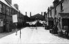
Two images sent in by Peter Turner of housing in the Aston area. The photographs were taken shortly before they were demolished in 1972. They are believed to be near Gt Lister Street.
The images were scanned from slides

I was wondering if anyone can recognise the location of the yards or if their locations (roads and street names) can be identified.


Aston old housing 2.jpg picture A


Aston old housing 3.jpg
picture B

pud
 
I lived in a back to back in Aston (Vicarage RD) in the 50's and these courts all look pretty much the same, depressing and soul destroying. Eric
 
Hi Pud, must agree with Cookie that the two lovely photos could be of a thousand similar courtyards circa 1920s-1970,s demolition and "improvements" to the inner circle of Birmingham housing, also note that the "Lead piping" had been torn up through the Bluebrick yard, probably the "shot-weights" already nicked from most of the windows and the wiring + old brass/copper gas fittings gone to scrapyard heaven for a few bob,,,, Also noted NO wet courtyard so no lead pipes left open but carefully bashed closed in consideration of the neighbours waiting to leave,, Mea Culpa, lol John
 
I grew up in the Great Lister Street area but sorry to say that I cannot help you with the photographs.
 
B picture is Lawrence Street Gosta Green, actually these were decent houses with front and back doors and not back to backs.They had a front room and a small back room, two bedrooms and an attic and also there own toilet and hot water boilers for washing!.
lawrence street (1).jpg
You can see the same brickwork trim in the middle of the buildings as in your original shot.
 
These were some of the first council housing to be built in the City together with Ryder St. You can see the City motto in the side of the house. One of these plaques has been saved and is now in the heritage exhibition in the museum . yardley 231.jpg
 
pudding

Here is a photo of the terrace in photo B in happier times, it even looks like the same washing on the line, it was a crime to demolish these houses as they were good sturdy properties their only crime was they stood in the way of the University expansion.
 

Attachments

  • Nechells Lawrence St Terrace.jpg
    Nechells Lawrence St Terrace.jpg
    153.5 KB · Views: 110
I'm looking for photos of the houses on the other side of the road to these and on the corner of Gem St but have yet to discover any:fatigue:.
 
I think Brumgum is right Picture B looks like one of the terraces at the bottom of Lawrence street, probably C Terrace judging by the factory in the background
 
I think Brumgum is right Picture B looks like one of the terraces at the bottom of Lawrence street, probably C Terrace judging by the factory in the background
Yes, one of me Dad's aeroplane models hanging from the roof gave it away Pam :friendly_wink:.
model-plane.jpg
 
At the back of picture A there is a doorway with a sign above it. This might just be the usual "No ball games" type of thing but it might refer to the building itself. As it is, you can't read what it says but you might be able to on a higher resolution scan.
 
Thanks Brumgum,Phil, and all for your replies at least we got picture A and the where about it was, as for picture B I 'm trying to work it out to a street plan if I can find one online of the area.
 
can any one remember how a house was in Lawrence Street ,Gosta either got bombed or caught fire some how? I can remember in Lawrence st always seeing a wreck of a house,,maybe 2 houses, they were all rubble,would like to add to my life story once I find the answer
many thanks waswigg
 
Many thanks for your reply sospiri Its funny as a kid that i should remember that house I wasn't born till 1951 so I wouldn't have known about it. Another bit towards my life story
waswigg
 
I had a look at the photos but couldn't seem to find the bombed house i can remember my mate robert banks used to live next door or so
waswigg
 
Keith Berry took this photo in 1958 identifying it as Lawrence Street.
13LawrenceSt1958.jpg
Edit amendment: This photo is actually the nearby Ryder Street See details in post#53 onwards.
 
Last edited:
thanks mike...i feel sure that these houses could have been modernised and made lovely homes for the needy....
 
Looking at a map showing Lawrence Street (date 1951) which I posted in another thread
https://birminghamhistory.co.uk/for...sta-green-recreation-ground.51111/post-668731
I can see a 'house' marked as a 'ruin' as shown in an enlargement of the map shown below.
Ruin.jpg

An aerial view (low res) dated 1945 shows some indication that something had happened to the house. Was it bombed or burnt-out ? Can anyone determine the house number ?
LawrenceSt1945.jpg
 
Last edited:
Hi All
we lived in Lawrence Street in 1958 at I think no 26
it had a back yard and was down near Duke Street
is there any photos of that end of the street
 
Hi All
we lived in Lawrence Street in 1958 at I think no 26
it had a back yard and was down near Duke Street
is there any photos of that end of the street
if you have not already seen them there are photos on this thread of lawrence st but only you will know if any show near the duke st end

lyn
 
have looked at current maps and can recognize the house, but cant read any numbers
have see the photos of the terrace houses, might be all there is
Thank you
 
Hi All
we lived in Lawrence Street in 1958 at I think no 26
it had a back yard and was down near Duke Street
is there any photos of that end of the street
hi barry could we have your parents names as we maybe able to find them on the electoral rolls which will confirm exactly the number of your house

lyn
 
Thank You Mikejee
that map shows the numbers very clearly, you have done good
I also lived in Lawrence st No 55 then moved next door to No 56.noticed on the map you printed it shows No 55 on corner of lawrence st and Gem st ,I recall this as morrisons shop.
 
Back
Top