• Welcome to this forum . We are a worldwide group with a common interest in Birmingham and its history. While here, please follow a few simple rules. We ask that you respect other members, thank those who have helped you and please keep your contributions on-topic with the thread.

    We do hope you enjoy your visit. BHF Admin Team

Kingstanding Community Centre 623 Kingstanding Road

Vivienne14

Kentish Brummie Moderator
Staff member
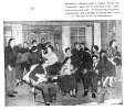
A centre built at a time when bringing people together as a community on a newly built estate became a priority. But it seems to me the community aspects were usually an afterthought and didn’t originally feature in many building plans at this time. But the Cadbury’s helped to make sure the human needs of a community were given some focus.

I don’t remember this Centre which has, I think, now gone. The centre we used was the Birmingham Settlement, near the Kingstanding Road/Tresham Road junction.

Viv.
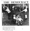
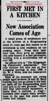
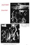
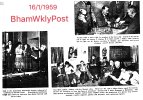
2ED3543D-51A5-4C68-AE09-02E88D62EF0D.jpeg13C5C788-2241-49B2-98ED-145A0859A74F.jpeg2146CB2A-28BE-4A36-8D35-8F816FA8B68D.jpegSource: British Newspaper Archive
 
Blimey Viv that's all changed, just did a Google Earth search on the address, it's all open space, further back towards the Harringay Road junction there's a Lloyds bank I think where I used to bank at the Birmingham Municipal Bank when I was a boy, not sure if it's on the same site.
 
Blimey Viv that's all changed, just did a Google Earth search on the address, it's all open space, further back towards the Harringay Road junction there's a Lloyds bank I think where I used to bank at the Birmingham Municipal Bank when I was a boy, not sure if it's on the same site.
Probably same site as Birmingham Municipal Bank became TSB which was taken over by Lloyds.
 
Yes Eric and Janice, definitely the same site. The original bank is behind the newer low level frontage. Always thought that bank was in an odd position, away from the Circle shops etc.

I can’t quite make out precisely where the Community Centre was. Maybe it was down an alleyway/lane set back from Kingstanding Road. Trying to find a photo of the exterior. Viv.
 
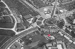
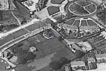
Was wondering if this (red dot) was the Centre on this 1955 aerial view ? Seems to be set back behind the shops and alongside the recreation ground. The recreation ground seems to have been used by the Centre for sports events. Viv.

F698E03A-1BED-4D9B-B6AC-8E706DCB7C6C.jpeg
 
Last edited:
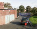
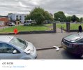
I think this must be where it stood, beyond the blue gates - this was in 2008, so it was demolished before that time. New (residential ?) building seems to have replaced it.

From newspaper reports it seems to have suffered vandalism and there were reports of the need to install security cameras in the 1990s. Even into the 1990s it seems to have been in active use. Viv.

2008
01741817-8CDD-4168-8D00-440693B59347.jpeg

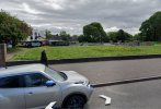
2022
89172C90-9632-4E36-B7EF-5F83338145CF.jpeg
 
In 1933 there was an organisation called Perrystanding Community Association at, I think, 621 Kingstanding Road. It served the communities of Kingstanding, Perry Common and the Kettlebouse Farm Estate. It was self-supporting with a small community hall. They made use of playing fields in Cooksey Lane. Later they developed the playing field that is now Wheeldon Recreation Ground.

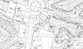
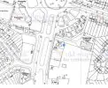
I wondered if the house shown on Mike’s 1950s map and in the aerial view (both copied below and showing possible location with a blue dot) was the hall of the Perrystanding Community Association ? And was this the predecessor to Kingstanding Community Association? Does anyone remember the old Community Hall ?

The modern view would be where this building once stood (around where the yellow flowers are).

Viv.
861AA1FC-5923-42A3-9839-B0369162695C.jpegB40BD492-B3E0-40FE-BA4E-E9B493F13212.jpeg
64F8F367-104E-405D-B56B-51058AF986DA.jpeg
 
After much research this afternoon, I’ve now discovered that the original Hall (built in 1933) was built using funds raised by public appeal. (Birmingham Corporation was originally involved in discussions to provide premises, but eventually pulled out).

According to Phil on the Kingstanding Wordpress site (I think this might be the late Phil who was a member of BHF) his comments about the Hall were:

The only memory I have of Kingstanding is demolishing the old Circle community centre inside the new one as they built it around the old one. A complicated and labour intensive job, as I remember it.

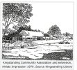
This drawing from Kingstanding Wordpress.com site shows the extended Centre in 1979.
68D67F41-03CE-45B1-8186-C3F35A459383.jpeg


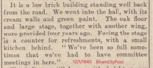
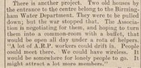
So the later Hall occupied the same site. There’s a description from 1940 about the building. The article also mentions an interest by the Perrystanding Community Association to make use of two old nearby. houses, but it’s unknown if this ever materialised. I’m not sure, but it’s possible the house(s) marked with a blue dot in post #10 could be those mentioned belonging to the B’ham Water Dept near the entrance to the Community Hall. Viv.

0E85EBC4-A948-4CE8-A583-6D4D1ABE04BF.jpeg3C9F0362-BE3D-4687-9DB8-5116BDA6B6E2.jpegSource: British Newspaper Archive
 
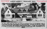
This was supposed to be how the Hall was meant to look. Hard to tell if this plan came to full fruition given the subsequent adaptations. But the principle was good, very much in keeping with a village hall.

Maybe someone remembers it looking like this ? Unless you approached the Hall entrance, tucked away behind the shops I doubt you’d recognise the design.

Viv.

E050DCF2-276B-4905-A8BE-EE28102A547C.jpeg
Source: British Newspaper Archive
 
Back
Top