• Welcome to this forum . We are a worldwide group with a common interest in Birmingham and its history. While here, please follow a few simple rules. We ask that you respect other members, thank those who have helped you and please keep your contributions on-topic with the thread.

    We do hope you enjoy your visit. BHF Admin Team
  • HI folks the server that hosts the site completely died including the Hdd's and backups.
    Luckily i create an offsite backup once a week! this has now been restored so we have lost a few days posts.
    im still fixing things at the moment so bear with me and im still working on all images 90% are fine the others im working on now
    we are now using a backup solution

Honey Lane

Bob Davis

Bob Davis
I have just looked up a relative on the 1851 census and the entry shows them living in the parish of Kings Norton, the village of Sparkbrook in what looks like Honey Lane. Did such a lane exist or have I translated the name incorrectly? Interestingly the father died four years later and they were living in Cregoe Street and he was buried at St Thomas. I don't know what he was doing there as in the census, he was an agricultural labourer.

Bob
 
Perhaps if you post the family name we can look at the original entry and see if other roads nearby help.
 
Jukebox in post #2 is correct - it is Stoney Lane.
If you go back in the census to page 34 the previous road is Alfred Street which leads off Stoney Lane - both still there today.

1615592682064.png
 
Last edited:
The earliest online map I can find is 1888 (surveyed). The houses in Stoney Lane are all north of Alfred Street - to the south are a couple of farms and not much else. If you click on the link below you should find a map. I would suspect that the earliest houses are on the left of Stoney Lane. Other than than I am unsure. You can remove the "blue square" by clicking on "switch print extent off" under the contact us button.
1889 map
 
He was an agricultural labourer, so possibly he lived in a tied house owned by one of the farms, but thanks for your help. Why he moved to Crego Street I will never know, he is a mystery man anyway, no birth, no wedding but children and a wife including one born about the time of his death and one born 10 years after when his widow was in her mid forties
Thanks again, how far from Solihull is Stoney Lane?

Bob
 
Roughly 6 miles.
I live about 5 miles from Solihull and I think Stoney Lane is about 1 mile further.
 
Just a thought- if your relative was in tied accommodation and was too ill to work he would have had to move. So perhaps Cregoe Street was forced on them either with relatives or with cheap rent?
 
Just a thought- if your relative was in tied accommodation and was too ill to work he would have had to move. So perhaps Cregoe Street was forced on them either with relatives or with cheap rent?
Thank you again, why I asked about Solihull is because on page 8, Solihull Borough 1841 census, second entry is a Henry Durose an agricultural labourer and I have often wondered if this was my Henry and the name misspelt so many times was written Incorrectly. But can you translate the address again please and where was it?
Bob
 
The address is Stoney Lane - there are no house numbers on the census - the numbers on the left are the schedule number.
Stoney Lane is a continuation of what is now Yardley Wood Road leading towards Sparkbrook and Birmingham.
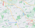
I am not sure where you would know: the red line is Stoney Lane and the red circle is Solihull.
1615741230935.png
 
The address is Stoney Lane - there are no house numbers on the census - the numbers on the left are the schedule number.
Stoney Lane is a continuation of what is now Yardley Wood Road leading towards Sparkbrook and Birmingham.
I am not sure where you would know: the red line is Stoney Lane and the red circle is Solihull.
View attachment 154389
Thanks for the map, the address translation I wanted was the Solihull one, but looking at your map, this is a long way to go every day
Bob
 
Sorry - it is in Olton but without looking again I am not sure where it is. It could be him in 1841 as he must have lived in. Interestingly the 2 children on the 1851 census were born in "Brougham" which could be Broom a village near Alcester in Warwickshire. Agricultural labourers often moved around.
When he was in Stoney Lane he probably worked at one of the nearby farms
Thanks again I have always assumed brougham to be a misspelling of Birmingham and unfortunately there was no house number in the church entry for the burial, just Cregoe Street.
Bob
 
The death certificate might provide a number if you needed to know it.
Will check Brougham in a bit.
 
First - the 1841 census. Is definitely Olton. Several large properties are named on the census - Olton Mill (occupation miller), Olton Hall (lots of staff) - these are easily identifiable on the earliest map I can find. The wording for Henry looks like Beggarly Green but the only place I know of and can find on maps is Ulverley Green. I know it is the right area as the last page shows "Broad Oak" and I know where Broad Oaks Road is today. Also Solihull Wharf is marked on the map and listed on the census.
Ulverley Green is on the earlier map I posted. There were several farms in the area.
I did notice the birthplace of Henry on 1841 and 1851 is different but that may happen when someone else fills in the info for an employee.
Secondly - I think you might be right about the spelling (or writing) of Birmingham for the children's births.
 
I have just found a reference to an area of Olton which used to be called Beggarly Green. I will follow that up and see if I can pinpoint where it was. However, it is in the general vicinity of the area I referred to in post 19.
 
I have just found a reference to an area of Olton which used to be called Beggarly Green. I will follow that up and see if I can pinpoint where it was. However, it is in the general vicinity of the area I referred to in post 19.
You are an absolute star to go to all this trouble for me, Henry has been a pain in the butt ever since I discovered him. His only records are on IGI, on FreeBMD and ancestry etc he does not appear until his misspelt name in 1851 living in Stoney Lane and then three years later he dies in Cregoe Street and of course there are children born after his death, I really must invest in some birth and death certificates, but thanks for all your hard work, I am really grateful.

Bob
 
I hadn't either and went to school in Olton. I have just found this reference to a congregational church which seems to pinpoint the area but have yet to find a map old enough (or clear enough) to show it.
In 1862 Warwick Road began a mission at Beggarly Green, Olton, (fn. 794) which eventually resulted in the opening of a chapel at Kineton Road, Olton. The footnote (fn 794) is simply a reference to their yearbook.
Am still on the trail.
 
Sorry - mods we have gone a bit away from the title of this thread. :rolleyes:

Haven't found a map showing the area but by the 1851 census the local area is Ulverley Green. That part of the census includes Olton Hall which in 1841 was in the section of the census including Beggarly Green. I assume that in that decade the name changed.
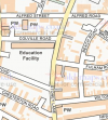
I think have found the chapel (from post 23) on a map - there is still a chapel building there but last time I went by it was a bridal wear shop- just by the railway bridge.
1615806369538.png
 
Last edited:
Sorry - mods we have gone a bit away from the title of this thread. :rolleyes:

Haven't found a map showing the area but by the 1851 census the local area is Ulverley Green. That part of the census includes Olton Hall which in 1841 was in the section of the census including Beggarly Green. I assume that in that decade the name changed.
I think have found the chapel (from post 23) on a map - there is still a chapel building there but last time I went by it was a bridal wear shop- just by the railway bridge.
View attachment 154435
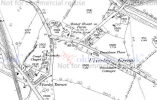
From these maps it looks like Beggarly Green disappeared when what is now the Warwick Road was struck through/straightened and became a Turnpike Road. It would be good to have a new thread on Olton and James Kent in place of 'The Red House, Snow Hill' which doesn't allow for much expansion, can anybody help on this please.
 

Attachments

  • Ulverley Green Road maps.JPG
    Ulverley Green Road maps.JPG
    301.1 KB · Views: 11
Last edited:
Sorry - mods we have gone a bit away from the title of this thread. :rolleyes:

Haven't found a map showing the area but by the 1851 census the local area is Ulverley Green. That part of the census includes Olton Hall which in 1841 was in the section of the census including Beggarly Green. I assume that in that decade the name changed.
I think have found the chapel (from post 23) on a map - there is still a chapel building there but last time I went by it was a bridal wear shop- just by the railway bridge.
View attachment 154435
Did Kineton Rd become Kineton Green Rd at some stage? I think the Beggarly Green chapel was on the corner of what is now Brookdale Rd. not the one that is now a bridal shop, why two chapels so close no idea.
 

Attachments

  • Screenshot (365).png
    Screenshot (365).png
    990.1 KB · Views: 4
Did Kineton Rd become Kineton Green Rd at some stage? I think the Beggarly Green chapel was on the corner of what is now Brookdale Rd. not the one that is now a bridal shop, why two chapels so close no idea.
Kineton Lane may have became Kineton Green Road when what was likely a cart track to Warwick Rd was urbanised when Olton Station opened in1869. The building next to the railway bridge in Warwick Rd was formerly a butchers shop with a blacksmiths shop underneath, this was bought by Congregationalists and converted to a Chapel in 1879, the upper part was the chapel run by a lay preacher and the lower part (the cellar) served as a school classroom although the dampness due to the brook running next to it made it unsuitable for children and in 1883 closed. The United Reform Church in Kineton Green Road on the corner of Brookvale Road by the architect John Osbourne opened on 1st January 1901.
Again it would be good to have a new thread on Olton and James Kent in place of 'The Red House, Snow Hill' which doesn't allow for much expansion, can anybody help on this please.
 
Back
Top