-
Welcome to this forum . We are a worldwide group with a common interest in Birmingham and its history. While here, please follow a few simple rules. We ask that you respect other members, thank those who have helped you and please keep your contributions on-topic with the thread.
We do hope you enjoy your visit. BHF Admin Team -
HI folks the server that hosts the site completely died including the Hdd's and backups.
Luckily i create an offsite backup once a week! this has now been restored so we have lost a few days posts.
im still fixing things at the moment so bear with me and im still working on all images 90% are fine the others im working on now
we are now using a backup solution
You are using an out of date browser. It may not display this or other websites correctly.
You should upgrade or use an alternative browser.
You should upgrade or use an alternative browser.
Hockley Hill
- Thread starter Astoness
- Start date
great photo lyn just how i remember before the fly over
my dad use to drink in the benyon
josie
quite sure our dad did too josie...
no moss..coming from the city centre gt hampton st finished vyse st it then became hockley hill which finished round about whitmore st and it then became soho hill....i have a feeling that the name hockley brook was just a name folk called that little area because of the brook i dont think it was an offical place to warrant it showing on maps or being used in addresses...mind you as ever i stand to be corrected moss
all the best
lyn
all the best
lyn
Last edited:
valerieexbrummie
knowlegable brummie
Re: hockley hil Hi . thanks so much for the pics of . do you have a pic of the
Hi to you all gt pics, does anyone have a pic of the left hand side of the hill looking towards Handsworth, just below the Post office, my father and Grandfather had a jewellery business, with there name on (Sanders) I would love a pic of it. the building was knocked down before I realised it.
valerieexbrummie
i have asked mike to help with the extact location of this great photo...no idea where it was on hockley hill dated 1961..by the time i was walking up and down hockley hill to work most of the old buildings had been demolished for the flyover
Hi to you all gt pics, does anyone have a pic of the left hand side of the hill looking towards Handsworth, just below the Post office, my father and Grandfather had a jewellery business, with there name on (Sanders) I would love a pic of it. the building was knocked down before I realised it.
valerieexbrummie
hi valerie could you give us a bit more info please as mike maybe able to post a map pinpointing where the business was by looking in the kellys directories...what was your father and grandfathers first names and what years were they at hockley hill
lyn
lyn


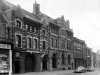
mike if you look at this photo again you can just see the letters ( gon works) on a building..this is the paragon works...next to that is another smaller building after that i think the building with the pointed frontage is the jewellery works..then after that would be charles sanders at no 43 which as you say is just out of shot on the right...what a shame but at least it will give valerie a feel for the area..
lyn
lyn
Attachments
Last edited:
The real interest for me in the section of the A41 between the junction of Vyse Street and Hockley Hill and the top of Soho Hill/Soho Road is that you can just imagine it like one of the villages in this country sunken under a reservoir which maybe will come to light in extreme drought conditions, or just once a year like the village of Brigadoon.
Unfortunately the reality is that this and many other parts of Birmingham were hacked away in the endeavour of what we call progress (the opportunity of city workers to get quickly in and out of town without observing inhabitants in the process).
Maybe one of the experts on BHF during the longer daytime hours sometime would like to arrange a guided educational tour of the area using the photos we've collected here. I'm booking up immediately!
Jayell
master brummie
My first job from school in 1954 was at Harry Astbury's Electrical Engineers on Hockley Hill. The firm was somewhere opposite the Palladium Cinema but I can't quite remember where it was. I used to walk to and from work most days as I lived just off Soho Hill in Soho Avenue. I am trying to find out what number in the road the offices/workshop was located at so that I can place it in connection with where I have found my 3 x gt.grandmother living in the 1851 census. This was 'Yard' Hockley which I believe to be between 71 and 72 Hockley.
Judy
Judy
Judy
On the map in post 33 , opposite Guest St is a building named on the map Abbey House. This is the address listed in the 1955 Kellys for Harry Astbury's (and also for Astbury & Madeley's). On the map it is marked 64, but it must have actually been 63-64. 71 and 72, with a gap leading to a large yard is visible 7 houses north of this
On the map in post 33 , opposite Guest St is a building named on the map Abbey House. This is the address listed in the 1955 Kellys for Harry Astbury's (and also for Astbury & Madeley's). On the map it is marked 64, but it must have actually been 63-64. 71 and 72, with a gap leading to a large yard is visible 7 houses north of this
Jayell
master brummie
Many thanks Mike - you are a star! I do remember that Harry Astbury's offices and workshops were set back from the road but couldn't remember the name Abbey House. The offices were at the front of the building with the workshop at the rear. I was taken on straight from school as a Junior Shorthand Typist and I must admit it was a bit of a shock to the system! Seeing your map has given me the position once and for all! And I can see 71 and 72 has the entrance to a Court between them - this must be the Yard that my 3 x Gt.Grandmother, Emelia Mackain, was living in 1851. By the census of 1861 she was living in Spring Row, which was situated at the top of Summer Row which at that time ran from Soho Street (now Soho Road) on the Ivy House Pub corner. If only I'd have known back when I worked at Abbey House that my 3 x Gt.Grandmother used to live nearby I would have explored the area more! Thanks so very much for your help.
Judy
Judy
The real interest for me in the section of the A41 between the junction of Vyse Street and Hockley Hill and the top of Soho Hill/Soho Road is that you can just imagine it like one of the villages in this country sunken under a reservoir which maybe will come to light in extreme drought conditions, or just once a year like the village of Brigadoon.
Unfortunately the reality is that this and many other parts of Birmingham were hacked away in the endeavour of what we call progress (the opportunity of city workers to get quickly in and out of town without observing inhabitants in the process).
Maybe one of the experts on BHF during the longer daytime hours sometime would like to arrange a guided educational tour of the area using the photos we've collected here. I'm booking up immediately!
hi richie....i like this idea...it would take a bit organising though...ie we would need maps and old photos printed off etc to help along the amble....leave it with me for a while and i will have a chat to one or two of our other members who may like to help...maybe something can be sorted out for next spring providing enough interest was shown
lyn
Last edited:

Is that any relation of Arthur Price of cutlery fame? I've had some Arthur Price cutlery for donkey's years and it's still going strong. Viv..
valerieexbrummie
knowlegable brummie
Hi Thank you so much for showing me on your map the building for Charles Sanders. it must have been demolished before 1963 as my parents had moved so I didn't pass it. I remember seeing that it had gone abt the last time I went to Handsworth. I hope someone will have a photo of that part of the Hill. Valerieexbrummie
valerieexbrummie
knowlegable brummie
Hi Just found the picture above, My grandfathers place must have ben the next one, I have downloaded this one thank you so much, maybe someone somewhere will have a picture further down. valerieexbrummie. I am still learning to find my way around the forum
Hi Mike
on the right of hockley hill on the map is shown metal works gas fittings would you know if this was Howlets factory, as my grandfather worked there till he retired I remember going on fishing trips with him from there by coach, but cannot remember whereabouts the building was, if anyone has a photo it would be much appreciated. edd
on the right of hockley hill on the map is shown metal works gas fittings would you know if this was Howlets factory, as my grandfather worked there till he retired I remember going on fishing trips with him from there by coach, but cannot remember whereabouts the building was, if anyone has a photo it would be much appreciated. edd
hi edd well remembered.... just checked the 1949 kellys and it was m howlett ltd gas fitting makers at no 140 hockley hill...i am always on the hunt for new hockley hill photos so fingers crossed..actually edd post 13 photo 2 may just show it in the distance.... the photo shows guest st on the left and howlets was just up from there...mike maybe able to be more exact...
lyn
lyn
Last edited:

In 1950 Blooms was 125,126 & 127, which must be the first building going away from Guest St. On the map 127 is marked furniture factory, and it looks as if the part of the site right next to Guest St had been demolished. Then there is a big building(s) marked 131-135, which must be the darker building, then a wall, which I take to be where there are assorted buildings set back from the road, and then the multi coloured block (Howlett's) , which I take to be the block marked "Metal works" with a gate (which is outlined in white in the photo) in the middle corresponding to the crossed gateway on the map, followed by the block marked 140 on the map. I may be wrong, but that seems to me to be the most likely.
