• Welcome to this forum . We are a worldwide group with a common interest in Birmingham and its history. While here, please follow a few simple rules. We ask that you respect other members, thank those who have helped you and please keep your contributions on-topic with the thread.

    We do hope you enjoy your visit. BHF Admin Team
  • HI folks the server that hosts the site completely died including the Hdd's and backups.
    Luckily i create an offsite backup once a week! this has now been restored so we have lost a few days posts.
    im still fixing things at the moment so bear with me and im still working on all images 90% are fine the others im working on now
    we are now using a backup solution

High Street Birmingham

Vivienne14

Kentish Brummie Moderator
Staff member
Find it hard to believe we don't have a High Street (City Centre) thread, but have been unable to find one. If anyone finds it, please let me know.

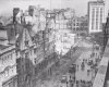
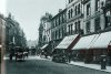
Two images of High Street. The first from Historic England site showing #84 and #85 High Street. The second showing a view down towards St Martin's with the Times Furnishing (now Waterstones) building on the left. Sorry no date for the first view but the second is 1950s. Viv

image.jpeg image.jpeg
 
!888 Kellys. George Skinner, jeweller between 86 & 88 High St. Not clear why they don't give it a number, especially as there is a number on the etching
 
!888 Kellys. George Skinner, jeweller between 86 & 88 High St. Not clear why they don't give it a number, especially as there is a number on the etching

mike are we looking at this from the town hall end or the bull ring end
 
Curiously the numeral on the Skinner building says 87. The awning on the shop opposite confirms High Street.
One thing I do notice in nearly all the pictures posted here, that date before 1960 or so, is how much more interesting shops and streets were compared to the often blandness of today.
 
couldnt agree more alan...if the etching is looking down from the town hall i think that must be the exchange building on the right corner jutting out..

lyn
 
couldnt agree more alan...if the etching is looking down from the town hall i think that must be the exchange building on the right corner jutting out..

lyn

Lyn it's looking down towards Dale End. So Skinners was at the junction of New Street and High Street. This was bombed during WW2 - the Big Top was then built. Viv.
 
This is also a view looking towards Dale End - sorry no date but must be pre-1900. Lots of wagons and carts along the street. And a later view (early 1900s ?) showing the Midland Arcade and Turkish Baths on the left. Viv.

image.jpeg

image.jpeg
 
Sorry Lyn, not sure what you mean about the Exchange. It is High St, and 87 is very close to the junction with New St. Tthe view is looking up High St, from the junction with New St(which goes off to the left of the artist
 
viv and mike totally ignore me...had a major senior moment got new st and high st mixed up....at this point i will go and have a lie down in a very dark room:D
 
Its understandable Lyn. I originally had doubts that it was High Street simply because the left hand side looks so different, and has done so since WW2. Like you I would never have seen it looking like this.

And of course any older view which includes Dale End is completely different today. Viv.
 
For ref, this is how that High Street/ New Street corner (where Skinners once stood) was obliterated in WW2. The view is looking down New Street, Times Furnishing straight ahead, High Street off to the left, Bull Ring to the right. Viv.
 

Attachments

  • image.jpeg
    image.jpeg
    133.4 KB · Views: 95
devonjim, I have always found the High Street / Bull Ring / Deritend / Digbeth stretch very confusing - and it's not that long is it?
 
Notable is the numbering of premises. It seems that at the time consecutive numbers were issued to adjacent properties rather than the more familiar odd one side evens the other. My comments are based on post 18, where the warehouse oon the right of the picture quotes numbers 63 and 64.
 
devonjim, I have always found the High Street / Bull Ring / Deritend / Digbeth stretch very confusing - and it's not that long is it?

I too think clarification of High Street would be useful as, I agree with Lady P, it is confusing. Here's a map from 1888.

Where does Dale End begin and end at this date? It looks like it was once a much longer road. I suppose it was cut short when the ring road was developed.

Looking south, where does High Street start ? And at what point does the road become (the later ?) Spiceal Street/Jamaica Row?

And at what point does Bull Ring start and end ? Viv.

image.jpeg
 
Viv
Looking at the numbering on the c 1850 map, High st ended at the junction of Bell st on one side and Moor St on the other side. At the other end it ended at Martineau St, where Dale end began.
The bull ring goes from Moor St to Park St
 
Looked up High St in Carl Chinn's "The Streets of Brum".
In 1553 map High St. began at Moor St and ended at New St.!(All beneath the 1960's Inner Ring Rd).By 1731 in Westley's map High St was called High Town. And by 1750 Bradford's map showed the name High St. was applied from the Bull Ring to Welsh Cross? (Was this Bull St/Dale End?)
 
Last edited:
Probably this picture has been posted before but it does portray High Street so I decided to post it. Picture from the e-papers repository.

bb0125.jpg
 
It is a Daimler but there is a larger picture elsewhere on the Forum - posted by the named person who is a member here.
 
Back
Top