• Welcome to this forum . We are a worldwide group with a common interest in Birmingham and its history. While here, please follow a few simple rules. We ask that you respect other members, thank those who have helped you and please keep your contributions on-topic with the thread.

    We do hope you enjoy your visit. BHF Admin Team
  • HI folks the server that hosts the site completely died including the Hdd's and backups.
    Luckily i create an offsite backup once a week! this has now been restored so we have lost a few days posts.
    im still fixing things at the moment so bear with me and im still working on all images 90% are fine the others im working on now
    we are now using a backup solution

Hamstead Road Church Hill Handsworth

Ian FOFB

Brummie yes ! Novice no !
Edit. Unfortunately the images referred to in this and some later posts have been lost. Images of the road have been posted later in this thread.

The 'then' pictures are taken from old postcards, the 'now' pictures taken from Google Streetview.
The pictures are thought to date from the 1900's and 1910's.

Another from Hamstead Road - I believe this house to be still standing - close to the the island and Wellington Road. Hard to tell fully as the property is shielded by trees on Google StreetView.

Another from Hamstead Road, the 'then' pictures are taken from old postcards, the 'now' pictures taken from Google Streetview.
The older of the pictures dates from 1904 .

Ian.
 
Last edited by a moderator:
Why, I wonder, Ian, does almost every image in your interesting sequence of threads look more attractive in the "then" rather than the "now" version? Sepia v. colour? Postcard photographer choosing a better view than the Google car? Wider view camera? The vegetation, and especially all the trees, now largely lost?............ Or is it just me?

Chris
 
chris
Here's what the modern one would look like in sepia (well almost, can't seem to get the cloud right))
Mike
 
Another gem Ian I know I am being thick but what was the pound for. I see its just outside St Mary's church.
 
wend..i also wondered what the pound was actually used for..maybe someone will be able to tell us...

great pic ian....

lyn:)
 
They were used to impound stray animals. There were several around. One that was there until they altered the road was by Old Church West Bromwich.
 
There you go Wendy and Lyn, ably answered by the Mikes before I had a chance to reply.
Ian.
 
Thanks Mike and Mikejee yes of course I should have known. It's nice to get more information though. xx
 
They were used to impound stray animals. There were several around. One that was there until they altered the road was by Old Church West Bromwich.

Mike I am being thick now which is the old church....is it All Saints?
 
Its the one at the end of Newton Road, turn left toward West Brom and its on your left hand side.
 
Thanks Mike it is All Saints I was christened there must go and have a look round.
 
I thought that this picture might be of interest. It's taken from the wall of St Mary's Church, looking down Church Hill Road. I believe the photograph to have been taken in 1908. The houses on the right hand side of Church Hill Road won't appear until the late twenties. The building, in the distance right of centre, is Heathfield Hall (formerly the home of James Watt). I believe that the house was demolished in about 1930 to make way for housing.

View attachment 64247
pencil.png
 
A few more photos of Hamstead Rd and the surrounding area. There is a photo of the old toll gate at the start of the road, a photo of Hamstead Rd itself near to the toll gate I would think. A photo of Church Hill Rd, and a close up of James Watt's house Heathfield Hall before demolition.

Phil

Handsworth Toll House Hamstead Rd .jpg Handsworth Hamstead Rd PC.jpg Handsworth Church Hill Rd.jpg Handsworth Heathfield James  Watt's House.JPG
 
Last edited:
I loved seeing those photos. I lived not far from Churchill Road (from Hamstead Road, left down Church Vale, right into Putney Road). I have many happy (and not so happy) memories of my first 21 years there.
That's life!
 
Another photo of the toll gate house at Hamstead Rd, interestingly enough this one shows that there were toll gates on both roads. I can only assume that the other road would be Lozells Rd?

Phil

Handsworth Villa Rd - Hamstead Rd Toll Gate. (2).jpg
 
Last edited:
When we were children, when ever we went to play in Handsworth Park, we had always used to visit a house in Handsworth that was situated in a road that went off Hamstead Road, almost opposite the church, next to the park.

The entire frontage of the house had been illustrated, and one of the scenes was Adolph Hitler peeking out from behind a tree. Do any other members recall this house?

Barrie.
 
Hi Barrie
Just been thinking about your thread since the other day about your strange looking designed old house
And I have come to the conclusion you are correct it sorts of sticks in my mind strangely enough if you came out of the gates and crossed over and started to walk up the hill
On that Hampstead rd the road took habit of a little bend and then you came to a brick wall about three or four foot tall and it laid back in the grounds habit
From the rd it had a long paths to the house and it had a huge front garden with over grown bushes and trees and it looked derict but with old dirty curtains
Black as coal and you could realized it was deserted and would say its been empty for years and adjoining it more or less next door theatre was a even
A larger house in I think Victorian building but it did have a name to it I could not tell ypou the name but it did have one ASD a kid. I do recall a funny house shaped house because me and my mates as kids laughed to each other and said what a funny house the tree type bushes was overgrown and leaning over the was on the pavement it never looked like the house next door with its gravel drive this was in the fifty I wonder whether or not is it worth a changenl in trying to
Find out exactly what it was and if we had an old map of the Hampstead rd we could work it out there I believe there was a house called bussel house
I have not got a number for it now I used to deliver million that area in the sixties up that neck of the woods coming from holly rd and there was big houses
I used to deliver too I wonder if mike ASD got any old map of that Hampstead red going back possible 1920 /30 period and we could try and calculate it
I sincerely believe you are correct in what you are saying best wishes astonian
 
The photo of Churchill Road is amazing!!! I lived in one of the houses on the righthand side from 1959 until 1972. The second house from the right belonged to the Avery family. Mrs Avery's father built this row of houses between the market garden (as was, just off the photo to the right) in the early 1900s. He lived on Gibson Road. They do not appear on the 1911 census so were built just after that. We still have a piano that we bought off Mrs Avery when they retired to Uphill outside Weston Super Mare. It had been given to her on her 21st and every 6 months it would be tuned. The tuner wrote the date on the wood inside, the last date was in 1939, just before the war. Road on the left is Wellesbourne Road.
 
I lived at 180. It was divided into flats. Mrs Day lived on the top floor, we were on the bottom with the garden.
Hi there the wall on the left of the last piture looks like the wall of our back garden facing Radnor Rd if I am right , my brother and I would seek out as kids on our go home made go kart from plans from blue peter. We would turn left out the gate and ride down the hill.our gran always knew when we did , and came down after us with a big stick. Had no choice but to grin and bear it .or loose the kart
 
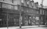
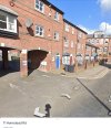
Not sure about the position of these shops, possibly replaced by the new buildings on the left of the modern view ? Viv.

4FFE8279-EDAF-491B-9889-437D09597786.jpeg18BF41AA-0D24-40CB-973A-91F054B8AFCC.jpeg
 
Back
Top