• Welcome to this forum . We are a worldwide group with a common interest in Birmingham and its history. While here, please follow a few simple rules. We ask that you respect other members, thank those who have helped you and please keep your contributions on-topic with the thread.

    We do hope you enjoy your visit. BHF Admin Team
  • HI folks the server that hosts the site completely died including the Hdd's and backups.
    Luckily i create an offsite backup once a week! this has now been restored so we have lost a few days posts.
    im still fixing things at the moment so bear with me and im still working on all images 90% are fine the others im working on now
    we are now using a backup solution

Gosta Green Through Duddeston

Rupert

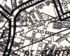
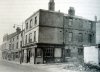
I see what you mean now, I thought you meant one of the buildings in Great Brook St. Yes I agree with you the house opposite the end of Great Brook St was Vauxhall House.

Ashted Row and Great Brook St came to a very tight junction at that point. In fact just at the back of the PN photo would have been my 4th photo at the end of Ashted Row Dr Tighe's house.

Phil
 
Thanks Phill, the pictures are all great of course but I like to try and put it all together. Just behind that little arched gate would have been a curved drive way to the old Manor and on the right of the driveway would have been a bowling green. Promenades would have been there, stretching on down to your houses on Inkerman and Dollman and also to the left at the bottom Alma Crescent. All of this was to be the future of course and by then there would be nothing left of this at all. I believe that Erskine is on the right of the sketch and it must have forded the Rea and later before that point it was to go under the railway branch which would probably have cut the gardens in half because I seem to have read that the gardens went down to the Rea whose banks were heavily tree lined.
 
rupert and phil.. ive found a couple more pics of vauxhall road. would you like me to post them...hoping they have not be on here before..

lyn
 
Lyn

Brilliant photo's, two of them I have never seen before, and there are not many of Nechells I say that about. Have you any idea to their location. I would guess at the one being the corner of Erskine St. The other one other than being on the north side of the road I wouldn't like to say. It could be somewhere around where Vauxhall Gardens School is now.

I think they are a little before my time, or I was a little too young to remember. So I'll leave it to some one else to locate them.

Phil
 
quite right phil..pic 2 is on the corner of erskine st and the other just says vauxhall road.. both cira 1950...glad a couple of them are of interest to you....

lyn
 
Looking at the unidentified photo from vauxhall road and the c 1910 map (most of the street below), it seems as if the only place for the photographer was at the position of the red arrow looking down the alley towards New Terrace (at an angle). the corner of northumberland st can be seen in the foreground. I think the houses between where the alley ran were 102 and 104
Mike
 
If #2 is Erskine Street then I think you can just make out Spooner St. just past the light coloured car.
The houses on Vauxhall Grove had long front gardens and seemed to be from an earlier period. I think strongly that they were the ones that you can see the backs of on the Gardens sketch. Before the Erskine St houses were built. They still maintained their long front gardens on the 1910 map above. Any chance of seeing a bit more of the 1910 map up to the right Mikejee

great!
 
My pleasure Rupert. the upper part is on a diffferent sheet and shownn below. It is dated 1902-11, so is slightly earlier in parts to the lower part
mike
 
From the position of 205 (the Working Boys Home) on Mike's map it appears that the photo was taken from Great Brook St and not Ashted Row as I previously had thought. As I said it was a very narrow junction.

It appears that at one time the Working Boys Home shared space with the Public Assistance Board. Now as my mother existed on that as her sole income for a while, you would have thought I would remember that. Perhaps it was before our time in Nechells.

Rupert the General Federation of Trade Unions was a little further down Vauxhall Rd towards Erskine St at 185. These was obviously premises with a union background and probably housed the Union you mentioned.

Phil
 
Super. Vauxhall Grove looks like it might have been a swell place at one time. Would these houses have dissappeared by our time.
 
Hi Rupert

The road that the photo was taken from must have been Ashted Row as it was on a slightly offset T junction.The house itself would have been just above Newdegate St going to-wards Erskine St. I think one of its last uses during the 50's was A Working Boys Home. I suppose today it might be called a hostel or would it have been an institution of some sort?

Phil

phil i think the road it was taken from is gt brook st (now revesby walk) right by our old house
 
Please can anyone help me out with the location of Duddeston Row. My Grandparents , Joseph and Ellen Spencer lived at number 51 in 1901.It says that he was Bookbinder and she worked from home as a milk shopkeeper ? Was there a line of shops there ? Would love a map or a picture , please .

Thanks , Isobel
 
Hello Isobel

Duddeston Row is a name I have not heard for a long time. Has your family got an Italian background because Duddeston Row was at the heart of the Italian community in the times you mention.

It was situated between Masshouse Lane and Curzon St. See the centre of the map. If you walked to town from Nechells as I did many times, you would walk along Curzon St, Duddeston Row and down Park St to the lower end of the Bull Ring.

The photo is a bit later than 1901 but it gives some idea of the types of shops.

Phil
 

Attachments

  • Birmingham Street Plan 1885 (1).jpg
    Birmingham Street Plan 1885 (1).jpg
    107 KB · Views: 18
  • Vauxhall Fox St off Duddeston Row 1949.jpg
    Vauxhall Fox St off Duddeston Row 1949.jpg
    113.2 KB · Views: 23
JK

I know as far back as I can remember it was always a hostel, I think the whole frontage there was owned by Italians. I haven't been down that way for years. I know that in the late 60's and early 70's it was still going because the chap who owned all the hot dog and burger carts in the town stored them at the back of the hostel which he owned as well. There was a sort of café on the front but I don't think they got many customers in off the street. I think it was for the residents benefit only.

There was another café on the corner with Bartholomew Row which was a little better. I think it was called Ledo's.

Phil
 
Isobel

I have just had a look in my 1903 Kelly's it reads like this for Duddeston Row.

here is Fox St

47 Thatched House PH John Willard
51 Spencer Joseph Shopkeeper
52 Evans Mrs Beatrice Pawnbroker
53 Golden Horse PH John Willard.

This means you grandparents shop is on the photo that I posted just past the corner shop.

Phil
 
Hi Phil, I'd forgotten about the other cafe, as you say much better-funny how time dims the memory, until it's given a jolt.
John.
 
Thank you all so much for the picture , map and information . I'm thrilled to bits ! I have no idea about an Italian connection as there is no one alive now to ask . Somewhere in my past I remember ice cream mentioned but when I asked my late Brother he laughed and said it was nothing to do with our family . Perhaps it was a family secret .On the 1901 cencus there were several Italians in that row including an ice cream vendor and a barrel organ player but the monkey wasn't listed .

By the way , it was my G.Grandparents not my Grandparents as I stated earlier ( sorry ) , I'm not quite that ancient .

Isobel
 
Thanks for that picture of Fox Street too, Phil. My SHIMEL/SHEMMELL great grandparents lived at number 42 in the mid-19th century. They certainly weren't Italian, though family legend had it that they were Jewish. Even that seems doubtful and it's more likely that they were originally Derbyshire SHEMWELLs mispronounced in much the same way as Tamworth gets pronounced as "Tammorth" is some quarters!

Regards,

Maurice
 
sospiri

Concerning Perry Pens, would that be part pf the building to the right of the tram. The building behind the tram is Halfords, the one that burnt down. I am just trying to locate the building in my minds eye before I make an intensive search. The thing is I have many photo's that are not indexed at all.

Phil
 

Attachments

  • Halfords 2.jpg
    Halfords 2.jpg
    104.2 KB · Views: 9
Hi Phil,

It really is incredible that so little exists of what was once was the largest manufacturer of pennibs in the world. A few nibs, boxes and artefacts exist on eBay and verious antique sites, but stocks are now running out. Had I just a few of the large cartons of nibs that my father brought home for us kids to play with, I would now be worth a small fortune, going by the prices they are now charging!

The angle of the building to the right of the tram would suggest that that building is not even in Lancaster Street. I've hunted high and low for a line drawing and all I can find is this box (which is also used on the Pen Room site, though I didn't lift it from there!). When I can find my copy of the "History of Renold", privately published by the company that took over the whole of the Perry group companies in the late 1950s, I'll check the chapter on Perry again, but I am sure there is no photograph of the Lancaster Street building in there.

As I remember, it was 4 storeys high and came right up to pavement in both Lancaster Street and Brick Kiln Street, which ran down the right hand side of the building.

Regards,

Maurice
 
Thanks Mike-g, but I'm already well acquainted with the Pen Room Museum and I have stacks of information from other sources too. What I'm looking for is a photograph of the old Lancaster Street building. It wasn't exactly small and I find it difficult to believe that one hasn't survived somewhere.
 
sospiri

Concerning Perry Pens, would that be part pf the building to the right of the tram. The building behind the tram is Halfords, the one that burnt down. I am just trying to locate the building in my minds eye before I make an intensive search. The thing is I have many photo's that are not indexed at all.

Phil
I think the building to the right is the fire station,

Brumgum.
 
Back
Top