• Welcome to this forum . We are a worldwide group with a common interest in Birmingham and its history. While here, please follow a few simple rules. We ask that you respect other members, thank those who have helped you and please keep your contributions on-topic with the thread.

    We do hope you enjoy your visit. BHF Admin Team
  • HI folks the server that hosts the site completely died including the Hdd's and backups.
    Luckily i create an offsite backup once a week! this has now been restored so we have lost a few days posts.
    im still fixing things at the moment so bear with me and im still working on all images 90% are fine the others im working on now
    we are now using a backup solution

Delving Round Digbeth

Peter Walker

gone but not forgotten
Delving round Digbeth, Part1
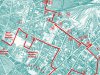
Last Tuesday, having seen a good weather forecast the day before, I got myself ‘advance’ tickets over the internet from London Marylebone to Birmingham Snow Hill (return cost £7.90 on a senior railcard). Armed with two ‘Discovery Trails’ the Museum & Gallery did about 20 years ago (price 30p each), I thought I would rediscover what little I remember of the area, and started off from Moor Street Station.
Park Street
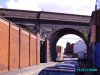
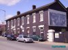
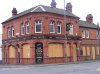
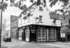
I turned left, and twice left again to bring me into Park Street, under the railway to Bordesley Street, where I turned right. Before turning I noticed the cutting where the railway runs into New Street, built in the 1850s, at the loss of much old property. Also visible was the empty shell of the once handsome old Fox and Grapes pub [Fig 1] at the corner of Freeman Street, which I remember closed only a year or two ago.
Once in Bordesley Street I saw the Victorian housing on the right, much of which was occupied by Italian immigrants at that time, who made a living mostly by making and selling ice cream. It seems still to be occupied, but I wouldn't jump at the opportunity. Opposite on the left is something I knew nothing about - the Polish Centre which, in addition to its social facilities, has a bistro bar. It was open, but I gave it a miss, much as I like Polish food and drink.
Allison Street
First into Allison Street, with a good Victorian building on the corner and towards the railway bridge. On the right before you get there is Shaw’s Passage, with a lively veggie restaurant and food store on the near corner.
Continuing under the bridge on the left are the remains of one of the many cast iron gents loos, which were very important in the days when Digbeth was a place for hard workers and hard drinkers. All sealed up today for obvious reasons. Further down on the right is a good-looking Victorian building used 20 years ago for making crisps, but built in the early 1870s for Corder & Turley, umbrella makers. Just past there on the right is Well Lane, which got its name from the artesian well bored about 1870 to supplement the water supply delivered by horse and cart to the majority of Birmingham householders at that time. Piped water was a luxury for the wealthy, supplied by a private company until Chamberlain municipalised it in 1875. Before 1870 the main public source of water was the natural spring near Ladywell.
Meriden Street
Then left into Coventry Street (not very interesting – all car and lorry parking), and left again into Meriden Street, and under the railway again, back to Bordesley Street. I recalled that there was once a tram track for steam trams to connect the northern section, with depots in Perry Barr and Aston, to the southern based at Kyotts Lake Road, Sparkbrook, with depots at Selly Oak, Small Heath and Kings Heath.
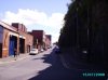
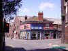
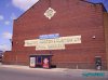
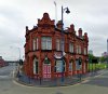
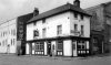
On the left-hand corner at the corner of Bordesley Street is the early Victorian ‘Spotted Dog’ [Fig 2] and, as the sun was getting warm and it was nearly five hours since I had my breakfast coffee, I thought it was time for a belated elevenses. None of my sort of beer, but the Guinness was good and not too dear, and the landlady was welcoming. There were two other customers, one was compiling the questions for that evening’s quiz, after trying them out on those present. A very nice old building.
From there a quick look at the big building nextdoor in Bordesley Street, to the right of the picture, which was originally Showell’s brewery, then the Birmingham Syphon Company, and later Pattison’s confectionery bakery.
On and along Bordesley Street through a tedious landscape of car parks and lorries, with next to no surviving older buildings. The remains of the former Typhoo Tips tea factory are a reminder of the famous blend which ceased production here in 1978.
Milk Street, Moore’s Row and Floodgate Street
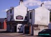
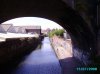
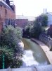
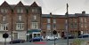
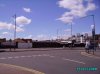
I turned right into Milk Street, past what is now Birmingham Central Backpackers’ hostel on the right, continuing as far as the impressive Floodgate Street School, one of Birmingham’s rare surviving Victorian school buildings, tuning left into Moore’s Row to reach Floodgate Street. Most of the surviving buildings here are used for storage, while a lot of land is used just for parking. Behind the vacant land on the east side can be seen the wall or fence enclosing the river Rea, now neatly contained in a brick trough. As I approached High Street Deritend I looked across the road, and could see against the sun the brick parapet wall of the present bridge over the Rea, which was once the cradle of the city of Birmingham [Fig 3]. And it is strange to think that the river marked the boundary of the Parish of Birmingham, everything to the left on this view would have been in the parish and manor of Aston. When Brum received its charter in 1838 and the wards of Deritend, Bordesley and Nechells were includeded in the new Borough of Birmingham, but local rates were still cvollected separately until 1851, when the Street Commissioners took over responsibility for roads and drainage. Until then, rates were always loser in Aston, but the standard of upkeep was lower than in Brum, where it picked up a lot in the 1840s.
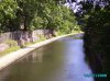
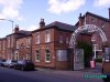
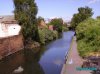
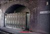
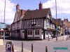
I turned left, walked over the bridge and along Deritend past the former Bird’s Custard Factory, now under restoration to reach Heath Mill Lane and the historic Old Crown pub [Fig 4] which I expectantly entered hoping for a nice drink in a congenial environment. The building is nice enough, and a fortune has been spent restoring it, but I was a little disappointed by the atmosphere, although it is true they were doing a brisk trade in the ‘garden’ at the back, in the hot sun. It is an intriguing old building, and there are quite a few old title deeds to the property on display. On the opposite corner I could see the former bank, which is now a bar on the ground floor, with some interesting musical instrument dealers above. Next to it is the old Free Library dating from 1865, which closed in 1949, but it’s still a very handsome building.
 

Attachments

  • DD map 1.JPG
    DD map 1.JPG
    336.3 KB · Views: 29
  • fig1 Fox and Grapes pub.jpg
    fig1 Fox and Grapes pub.jpg
    216.7 KB · Views: 28
  • fig2 originally Showell’s brewery.jpg
    fig2 originally Showell’s brewery.jpg
    194 KB · Views: 28
  • fig3 cradle of the city of Birmingham.jpg
    fig3 cradle of the city of Birmingham.jpg
    149.3 KB · Views: 26
  • fig4 Old Crown pub.jpg
    fig4 Old Crown pub.jpg
    223.1 KB · Views: 27
Last edited by a moderator:
Delving round Digbeth, Part 2
Heath Mill Lane, Lower Trinity Street and Adderley Street
Once refreshed I set off along Heath Mill Lane, and turned right immediately after passing under the railway viaduct which straddles and dominates this low-lying area. It is hard to imagine today that this was once a residential street, even after the railway came in the very late 1840s: to make the intrusion worse, another viaduct was also built for a connection to Curzon Street Street station, but this was never finished, although its massive, gaunt blue brick masonry arches over Hack Street and Allcock Street [Fig 5] still standing.
Adderley Street
At the end of Lower Trinity Street I stepped briefly to the right to look up Uppare er Trinity Street, which I knew once had back to back houses on the left hand side, opposite the massive viaduct which supported Bordesley Goods Depot [Fig 6]. I then turned back and continued along Adderley Street as far as the Wagon and Horses [Fig 7], which I found quite charming although it has had a chequered career in recent years, having become the Cannonball Jazz Club in the 1980s and early 1990s. I couldn’t resist a pint in there, the one I enjoyed most that day. Then on and left into Liverpool Street, to see the bus garage [Fig 8] again. I had seen it only once before, but that was when I was about ten in 1943. I can remember being impressed by those gaunt unfinished railway bridge piers which punctuate the junction with Garrison Lane, where I made a worthwhile detour, turning right to look over the Warwick and Birmingham Canal bridge [Fig 9]: looking towards Warwick the scene is quite rural.
 

Attachments

  • fig5 masonry arches over Hack Street and Allcock Street.jpg
    fig5 masonry arches over Hack Street and Allcock Street.jpg
    226.2 KB · Views: 21
  • fig6 Bordesley Goods Depot.jpg
    fig6 Bordesley Goods Depot.jpg
    133.4 KB · Views: 20
  • fig7 Wagon and Horses.jpg
    fig7 Wagon and Horses.jpg
    188 KB · Views: 21
  • fig8 Liverpool Street bus garage.jpg
    fig8 Liverpool Street bus garage.jpg
    229.3 KB · Views: 21
  • fig9 Warwick and Birmingham Canal bridge.jpg
    fig9 Warwick and Birmingham Canal bridge.jpg
    295 KB · Views: 19
Last edited by a moderator:
Peter what an absolutley wonderful account of your trip. I felt like I was actually there especially with all your added historical knowledge. I think the piece should be added to the main site...........thank you so much!
 
Delving round Digbeth, Part 3
Garrison Lane
Crossing Garrison Lane gingerly, I looked over the opposite parapet towards Town [Fig 10]. Again the scene was dominated by the unfinished railway viaduct, with the former Corporation wharf on the right beyond it.
Fazeley Street
Back as far as the Forge pub [Fig 11], and resisting the temptation to sample its wares, I turned right into Fazeley Street. On the left my 20-year old guide notes led me to hope that one of the last blocks of back-to-back housing would still be there, but now it is – like so many other plots – a car park. Beyond that on the left, the SDUK map of 1839 shows a vast mill pond, but this whole area was filled in soon afterwards and built over. Heath's Mill would have been on the site of the big buildings behind the Forge pub in the picture. The two buildings on the opposite side of Fazeley Street were a former local Unitarian Sunday School and Chapel, both of which were being refurbished for other uses [Fig 12]. My photo shows the Sunday school on the left and the old chapel straight ahead, with part of the old slated roof replaced by glazing].
Walking on towards Town, it was only a few paces before I reached what is now called The Bond [Fig 13], used as studios and offices, formerly Tansley’s Ice Manufactory, which supplied Birmingham’s hotels and restaurants, before the days of cheap refrigerators. A little further and Fazeley Street crosses the river Rea [Fig 14]. This view shows the river, looking into the sun, upstream towards Digbeth. Again, Aston was on the left, Birmingham on the right.
 

Attachments

  • fig10 opposite parapet towards Town.jpg
    fig10 opposite parapet towards Town.jpg
    185.8 KB · Views: 16
  • fig11 Forge pub.jpg
    fig11 Forge pub.jpg
    240.6 KB · Views: 18
  • fig12 former local Unitarian Sunday School and Chapel,.jpg
    fig12 former local Unitarian Sunday School and Chapel,.jpg
    351.1 KB · Views: 17
  • fig13 formerly Tansley’s Ice Manufactory.jpg
    fig13 formerly Tansley’s Ice Manufactory.jpg
    216.7 KB · Views: 16
  • fig14 river Rea.jpg
    fig14 river Rea.jpg
    440.7 KB · Views: 16
Last edited by a moderator:
Delving round Digbeth, Part 4
Fazeley Street
Next on the right then comes the former headquarters of the canal carrying company Fellows Morton and Clayton [Fig 15], established there by Joshua Fellows in 1879, while the name of Pickford and Co, better-known today, also started in the vicinity, giving the name to the next street on the left, which incidentally is still paved the old fashioned way with granite setts, popularly known as ‘cobbles’.
Beyond that, still on the right-hand side, comes what looks like a block of blue brick houses [Fig 16]. This was the facade to the former Junction Works, which produced confectionery, including boiled sugar sweets, candy, creams and ‘coconut chips’. We then comes another canal bridge, and from the left parapet we can see the remains of the Digbeth Basin [Fig 17] with the former fingers of land used for loading and unloading now used for car parking, where possible – the remainder being overgrown by bushes and trees. It is hard to imagine now, but the Digbeth Branch was built at great expense as a branch from the Birmingham and Fazeley Canal opened in 1789 to serve the early factories in this, the oldest part of Birmingham.
At some peril I crossed the road to look over the other parapet, which revealed the course of the Digbeth Branch canal towards the Fazeley canal [Fig 18], before it disappears under the railway. The red brick building in the middle of the picture is part of the Birmingham Gun Proof House, while the profuse vegetation on the right conceals the junction with the Warwick and Birmingham Canal, opened in 1793. A few steps further, and Andover Street forks off to the right. On the far corner was a former pub, the Royal Oak [Fig 19], dating from 1827, which closed in 1934, but the buildings have remained in use as offices. The eccentric colour scheme today may indicate that it is no longer occupied.
 

Attachments

  • fig15 fellows morton and clayton.jpg
    fig15 fellows morton and clayton.jpg
    262.9 KB · Views: 17
  • fig16 facade to the former Junction Works.jpg
    fig16 facade to the former Junction Works.jpg
    225.1 KB · Views: 18
  • fig17 remains of the Digbeth Basin.jpg
    fig17 remains of the Digbeth Basin.jpg
    216.7 KB · Views: 18
  • fig18 Digbeth Branch.jpg
    fig18 Digbeth Branch.jpg
    265 KB · Views: 19
  • fig19 Royal Oak.jpg
    fig19 Royal Oak.jpg
    215.7 KB · Views: 18
Last edited by a moderator:
Thanx Peter for letting us take part in another of your fantastic, interesting and informative walks around our city of 'Brum'.

Pom
 
Delving round Digbeth, Part 5
Banbury Street and New Canal Street
Walking up Andover Street I got to Banbury Street with the Proof House [Fig 20] at the end, which I have never seen before, other than from the train.
Then back along Banbury Street to New Canal Street and the former Eagle & Tun [Fig 21], an elegant 1900-vintage pub rebuild, which survived in business until about six weeks ago, but was already boarded up when I passed. I was in there two years ago when I photographed it before, and it was rather forlorn inside then. Then along New Canal Street to look at that enormous white elephant, the former entrance portico to Curzon Street station [Fig 22] opened to traffic in 1839, but closed to regular passenger traffic when New Street Station opened in 1854. To conclude my little walk I called in that old favourite, the Woodman [Fig 23], on the corner of Albert Street, an 1897-vintage pub rebuild by James and Lister Lea, which alas has seen better days. Some 25 years ago it was used twice a week by the infamous Peter Sutcliffe, the Yorkshire Ripper, who used to meet his lorry driver friends here. It was listed as a historic building grade II in the 1990s and acquired by the council, but was closed for a time, during which certain vital features such as the Smoke room fireplace were stolen. It reopened, and has struggled to regain some trade. Last Tuesday it was occupied by a party of developers and surveyors, which implies that some changes are ahead, though who knows what?
I walked out of the Woodman at about 2.45 pm, almost exactly three hours after I started in Park Street, having had four pints in four different pubs, and looked at countless buildings. The weather being so fine, my memories are all very sunny, and I really feel I have got to know Birmingham a lot better, thanks to this little tour.
Peter
 

Attachments

  • fig20 Proof house.jpg
    fig20 Proof house.jpg
    198.6 KB · Views: 18
  • fig 21 eagle & tun11.08.08.jpg
    fig 21 eagle & tun11.08.08.jpg
    218.4 KB · Views: 15
  • fig22 curzon st.jpg
    fig22 curzon st.jpg
    320.2 KB · Views: 15
  • fig 23woodman.JPG
    fig 23woodman.JPG
    146.6 KB · Views: 14
Last edited by a moderator:
peter. what a read. i have learnt so much. if you have any other accounts of your travels on this or other areas i am sure this would go down well as a short paperback. thanks again. wales.
 
Thank you for that tour, Peter. I printed the map and followed your footsteps via my computer screen, learning about various properties I've seen and thought "I wonder what that was originally?" like the chapel in Fazeley Street and the 'Bond'. There is so much forgotten history in that part of our city, most of it now lost for ever.
 

Fantastic! Thank you Peter it's so informative a brilliant piece!
 
Peter, that was absolutely fascinating! I did so enjoy reading about your walk, and wished I could have been on it with you, as you know such a lot about the places on your tour. The historical facts, together with the up to date photos and map, made this a wonderfully informative and interesting read.

Judy
 
Thank you peter. Your pieces are always so readable, interesting and full of detail. Makes me feel I am with you
mike
 
Great post Peter with good historical info and pictures presented in very readable fashion. i suspect a few more might be following in Peter's footsteps in the coming weeks, me included

Bob
 
Peter my friend, after walking around London and Greenwich with you last summer. I really do feel like I'm with you on this walk, I can hear you voice explaining the history, buildings and the area.
Thanx a million.

Pom
 
Absolutely fantastic, this excellent account of your journey has provided me with some knowledge of the area. It is now my intention to follow in your footsteps during the summer - tracing your route from the map.

Peter - I endorse your appointment as Birmingham's own ALFRED WAINWRIGHT.

Where are you going to delve next? I can't wait.

keith
 
Thank you for you kind comments. I have done some tweaking this morning, and replaced the missing pictures which bounced off yesterday. Yes it is a labour of love, but I really enjoy discovering new things and it's always nicer to share them, although some think it's a bore.
I have to acknowledge the two trail guides which prompted me to see for myself, and which gave most of the information, and also two kind people who asked me if I needed help. (Last year, when I stood still on a back street in Highgate to admire the view of central Brum, a man came out of his house to ask if I was all right. I'm sure he would have lent me a chair sit on, but that wasn't the problem.)
The guides round the Jewellery Quarter [https://www.jquarter.org.uk/] are excellent. Barbara and I did a smashing last year starting from the Canal at Gas Street and along the bank to Monument Road, the to Edgbaston Reservoir, which I had never seen before, then back to Five Ways and the Prince of Wales in Cambridge Street for Sunday Lunch.
I have wandered a lot round the Islington side of Broad Street, and down over Bristol Street and Pershore Street towards Highgate and Balsall Heath. I should like to do the rest of Bordesley, around Watery Lane and Garrison Lane, though I fear there will be little left to see. It's always best to do some homework before starting, and to take an Alan Godfrey repro map with you. They give the most reliable picture of what was on the ground a century ago.
Peter
 
one thing it most definately is not peter is boring. i know you are a busy person and may not have time but i still think its worth putting into print. carry on roaming. all the best wales.
 
Thankyou Peter for a marvellous and informative walk in the comfort of my home,a lot of time and thought went into it no doubt,thankyou once again.Mary
 
Thanks, Peter. That was amazing. Having known relatively nothing about any of this, you have really opened my eyes to the beauty of Bimingham. You've also made me think how wonderful it would have been to be with you when you went on your tour. In fact, would it be at all possible to organise a tour of this sort for others, do you think?
 
Thank you Peter for explaining many of the places I saw when I worked in Digbeth over several years. You mention the Polish Club. The Midland Red (Digbeth) Social Club rented the function room for dances at the Polish Club many times. This was because their own small Club then on the corner next to Digbeth Police Station just couldn't cope with the numbers attending. There was always a warm welcome off the Polish folks there and now the extra Polish must make it a busier place than it has been for years.
 
Fascinating trip, Peter. Thanks so much. I have to agree that there is much of interest in this part of town. I've attached some that caught my eye when I was walking around the city taking pictures for my book way back in April 2006.

First one is a very ornate gents (closed of course) where the railway line to Moor Street passes over Allison Street. Second are some nice old houses on Bordesley Steet. Third and final is an old street sign close to the junction of New Canal Street and Curzon Street.

I wonder if they're all still there? Two years is a long time when it comes to redevelopments around the city - especially with EastSide going on!


Fat Mark
 

Attachments

  • bordesley st.JPG
    bordesley st.JPG
    120.1 KB · Views: 16
  • Allison St Urinals.jpg
    Allison St Urinals.jpg
    174.5 KB · Views: 14
Last edited by a moderator:
Another superb walk with you, Peter. Thank you for writing about your day, with such clarity, I was by your side the whole way.
 
Hi Peter: Just read your "travelogue" up to Birmingham and your day searching out
places that you remember. I enjoyed reading your account very much. Thanks for posting.
 
really enjoyed that peter ,was great to see the old places. i almost forgot some of them ,great to have yer memory tweeked like this as a lot has dissapeared nowadays thanks again.
 
How did I miss this first time round?
Most my family was born in Allcock street till they were bombed out during the war, then moved to Erdington where I was born.
Thanks for a great read Peter
 
Peter, what a cracking read. I run a small business in Moseley Street, Digbeth, so spend a good deal of my time in and around the area. You've certainly opened my eyes to my surroundings.
Of particular interest to me is the unfinished railway bridge at the junction of Liverpool St and Heathmill Lane. Why was the spur never finished? And what is that rather interesting arched portico that's set into the brickwork for? I refer to the very corner of Liverpool Street.

I drive by here several times a day and remain intrigued.

Ian
 
From https://billdargue.jimdo.com/placenames-gazetteer-a-to-y/places-d/deritend/ a site I can well recommend for information on Birmingham:

"The 58 arches of the Bordesley Viaduct are a major landmark of Digbeth and Deritend. Built in 1852 by Isambard Kingdom Brunel, this Grade II Listed viaduct carries the Birmingham & Oxford Railway across the Rea Valley. The viaducts from Snow Hill Tunnel and from Moor Street Station join just before passing over Allison Street.
The Bordesley Viaduct is then joined by the Duddeston Viaduct which was built in 1846 to link the Oxford and London lines with the new station being built at New Street. However, when the Great Western Railway bought the Oxford line in 1848 and Snow Hill Station was opened, access to New Street was no longer needed and work on the almost completed Duddeston Viaduct was abandoned. Only a small part of the line near Bordesley Station was ever used and that as cattle sidings which still remain high above Upper Trinity Street. Some arches over roads have been demolished but most remains. The unfinished end of the viaduct can be seen in Montague Street."


It is often called "The viaduct to nowhere".
 
Lloyd, thank you for that, I'd half suspected it was something along those lines.....pun fully intended.
icon7.gif


I'll have to take a photo of the arched entrance/doorway set into the Liverpool Street brick buttress and post it on here, maybe someone will be able to tell me what it was all about.

Ian
 
hi peter
i must compliment you on your work and as some-one said we should have it
on the main site and i entirely agree
peter did you take those photographs they was excellent and proffessional
taken;
and if you had taken them ;or in fact whom ever did take them
the one for the spotted dog especially brought some memorys for me as well
because the person whom had taken that photograph
was across the rd at a angle on the other corner
by the street lamp postand standing there taking that pic was the open ground
of my grand parents whole property which did take up the whole corner
and some of bordesley street because ajoining it was typoo tea
and there house was the big house for transport drivers whom came to market and stayed over night and the excact corner peice was the coffee house front door
and where you or any body else had taken that pic there would have been a fire stand right out side by the kerb where you used to smsh the glass with a little hammer it used to have and speak to central fir station
that was there up till about 1953--4 before they removed it
and also there was a police stand with the doors for the police to call in
that was there long before the fortys
it was nice to see the old spoted dog spruced up it was looking wearer
in the 40=50,s it certainly as transformed
i have such good memories of my grand mother and her giant christmas trees
that filled the room and upto the ceiling and presents for dozens of people
from all over the globe whom was relative canada scotland all stayed for the festive season before going home
as i have said i had alot of child hood memoriesof the corner coffee shop
and the ajoing house on the oppersite corner there was an old fashion little garage
that i think is recorded in one of the history of carl chinns book
many thanks for the memory and weldone for your work
best wishes astonian;;;
 
Back
Top