• Welcome to this forum . We are a worldwide group with a common interest in Birmingham and its history. While here, please follow a few simple rules. We ask that you respect other members, thank those who have helped you and please keep your contributions on-topic with the thread.

    We do hope you enjoy your visit. BHF Admin Team
  • HI folks the server that hosts the site completely died including the Hdd's and backups.
    Luckily i create an offsite backup once a week! this has now been restored so we have lost a few days posts.
    im still fixing things at the moment so bear with me and im still working on all images 90% are fine the others im working on now
    we are now using a backup solution

Dates of the first tramways up to Villa Cross from Heathfield Road, Villa Road, Lozells Road and Barker Street.

Myrddin

master brummie
1611596938448.png
Resource Details - Birmingham Images

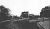
The lamp shown on the left hand side of the above photo maybe the original Founders Lamp of Aston Villa Football Club. I desperately want to find out if it is, :), or if it isn't, :(. To do so I need: an accurate date for when the photo was taken; and, the date the lamp was erected.

I think I can see a tramway going up Villa Road to the cross and on to Lozells Road. I cannot see any tramways on Heathfield Road or Barker Street. If we know when the first tramways opened on all four roads leading to Villa cross then we can narrow the date range for the photo.

Any help will be very much appreciated by every Villan who loves his early history of the club and also, of course, AVFC.

If you are interested in following the thread for the Founders Lamp, it's in a thread about Villa Cross.

Villa Cross | Page 2 | Birmingham History Forum
 
Last edited:
pretty certain there were no trams on barker st and possibly non running down heathfield road...bit more info here

On 23rd November 1874, a branch from Soho Road to Villa Cross via Villa Road was opened off the Birmingham and District Tramways Co. Ltd's horse tram route between Monmouth Street (later Colmore Row) via West Bromwich to Carters Green and Hill Top. Unlike the later tramways, this was to 4' 8½" gauge.
On the 24th May 1876, a new Company, the Birmingham Tramways and Omnibus Company was formed to purchase the tramway, which waas in financial difficulties.
In 1885, the Company’s lease on the Corporation owned sections (within it's boundaries) expired and on 1st January 1886, the Company’s rolling stock and tracks outside the city of Birmingham were purchased by the Birmingham Central Tramways Company, who also took over the lease of the Corporation-owned tracks within the city.
On 24th March 1888, the former horse tram route from Colmore Row to Hockley Brook (by then rebuilt to 3' 6" gauge) was converted to cable traction by the Patent Cable Tramway Company, and, on the 20th April 1889, the line was extended to Handsworth (New Inns). Presumably the remaining sections remained under horse operation until the whole was converted to electric traction by the Corporation.
 
Yes Lyn. I was a bit mystified by a map which seemed to show a route down Heathfield road, but using a magnifying glass on the rather small print found one was authorised, but not built
 
Thank you all for pursuing this line of investigation. From the BNA I had read the plans for tramways along Heathfield Road and Barker Street, but had never read evidence that they existed. Now I know why; they never did. I bought an online ordinance survey map for 1888. Thumbnail below. It confirms all that you kind people have told me.

1611694445860.png
https://midland-ancestors.shop/BH-LXVIII.16.25?search=BH-LXVIII.16.25

I do not understand all the symbols and abbreviations but the tramways are clear, as are the three lamp posts (L.P) on the photo. Notice that a central lamp in front of the inn has not yet arrived. The map closely matches the photo.

Example 1. On the photo, on the right hand side, there looks like a stop cock in the road to the left of the largest lamp post. It matches up to a V on the map - V for valve (water) perhaps.
Example 2. On the photo there is a gateway just behind the 'founders' lamp and from the map we see it leads through to a gap between the houses, although the gate is not shown.
Example 3. On the photo the house behind the founders lamp does not have a wall with pillars like all the other houses, but instead has a fence; and, there are three trees to the front of its garden; this is shown on the map too.


Most importantly, the tramway in the photo does NOT divide into two tracks but continues into Lozells Road; we do not know how far. On the map the tramway does divide into two before it continues into Lozells Road. The Lozells tramway opened in 85. On the full map, looking east, we see that a huge amount of work has been done on the tramways by the time of the survey in 88. Was all this completed in 85? In particular, did the divide into two tracks, which starts at the top of Villa Road, take place in 85? My guess is that the divide did. If so, then this dates the photo from between 1874 and 1885. If not, then this dates the photo from between 1874 and 1888. However, to be sure we'd need to see the plans of the tramway company who laid the tracks, or some other evidence.

Other photos show there were no overhead cables to support an electric tramway at this time. The fuzzy B&W one below is dated 1901. The sharp sepia one shows how the electric trams looked. These photos were very kindly emailed to me by Professor Carl Chinn - a Villa fan. :)
1611697716791.png 1611698741114.png
 
Last edited:
Some interesting comparisons. This does not affect any of your conclusions, but I should add in case this affects any other conclusions that anyone might make from the map, that the map you purchased has had additions to the original (it being scanned from an original modified slightly by Birmingham corporation work dept}.The original (though more blurred is below and contains additional shading showing later changes to buildings and other slight changes ie . addition of L.H. ( which is OS. marking for lamp house) by cab stand

map c1888 villa cross.jpg
 
Wow! Thanks for that. I was a bit confused by some of the markings on the map I purchased, and now I understand why. L.H lamp house. Is that the conservatory type waiting room. I see the cab stand on Heathfield Road on the map has no L.H. What did they mean by cab stand? Was it just the strip of road where cabs were allowed to stand? Like a taxi rank today. And a lamp house a waiting room with lighting? Looking at the two latest photos it seems that the lamp house ended up at the front of the hotel!

Can I ask for your opinion, Mike. What's your gut reaction to the quest I'm on. Do you think the lamp post on the photo may be the one that was there in 1874? Or do you think I'm wasting my time?

I must say that I have very much enjoyed learning about this era at Villa Cross. It's been fascinating.

On the Birmingham Council map there is an L placed on the pavement in front of the inn, which is not there on the original ordinance survey map. Interestingly, as said before, in 1888 the Aston Manor Local Board agreed to erect a lamp there. Obviously, the L shows they were on to it, although the lamp was actually put up nearer to Lozells Road than shown here. Little details like this make me happy. Is that sad?
 
Last edited:
I'm afraid I don't really know about your lamp. I think you may well be right about it being that lamp, but would not like to say definitely. Cab stands were designated places that cabs could wait, a bit like a taxi rank. Sometimes there was a bit, where they could make tea etc, though I don't think there was one here. I think that a lamp house was just a lamp marking the position of the stand.it think it is too small to be a room. Perhaps lamp-housing might be a better term.
 
Hi again Mike. Sorry to trouble you again but I have another question. I agree there's nothing on the map to show anywhere to make a cuppa, but on the photos, on the Lozells Road, there is a wood and glass building shown, like a summer house. On the ENTIRE photo there is no pipe coming out of the roof but on the 1901 photo there definitely is. (I cropped the sepia photo to reduce the file size for posting, but on the original the wood and glass building in front of the hotel has the pipe indicating that it's the same 'summer house' that was on the road) Originally, in my ignorance, I thought the 'summer house' WAS the cab stand, and that it was a waiting room for customers! Now, it occurs to me, from what you've said, that that was where the cabbies could make a cuppa and keep warm; and, this explains the chimney pipe which is obviously attached to a stove. What do you think?
 
I'm not quite sure what you menm by the pipe, but do, on close inspection think that there was a "summer house,"( probably a cabmans tearoom ) on the photos., though It looks to me (though possibly wrong) that it was in a different position in the 1900s one. This means that the LH was in fact a small shelter and not just a light. However it is definitely not on the original c 1888 map, so must have been added later than that
 
1611759929608.png 1611759986086.png
It looks to me as if the cabmen's tea room had a chimney pipe in these photos and that it had been moved from off the road (B&W) away from the tramway, and propped up on bricks by the entrance to the hotel (Sepia). There is a cabmen's tea room on the ENTIRE photo too but it doesn't have a chimney then. I think the OS original map got it right. It is a temporary/moveable tearoom and should not be on a map in the same way as a caravan propped up on bricks, selling burgers would not be on a map today. It reminds me of a dine-in, caravan-café which for decades was always left in a layby on the Newton Road. I was told that Sandwell council made the owner move it to prove it was not a permanent building. He moved it from one place in the layby, to a different place in the layby (it's a very big layby) and Sandwell Council said fair play mate, keep on trading! I used to drive past it every day going to work.
 
just going a tad off topic i take it you know where the villa ground was before they moved to villa park? if not i have a map if you are interested

lyn
 
Last edited:
just going a tad off topic i take it you know where the villa ground was before they moved to villa park? if not i have a map if you are interested

lyn
Yes, it was a small stadium in Wellington Road in Perry Barr. This link, Stadium - Wellington Road Ground, Perry Barr (englandfootballonline.com) is interesting because a lot of people do not realise that the England team played a match there. The maps given on the site are very small, so .. yes please Astoness, I'd love to see the map you have. Thank you. :sun:
 
Interesting photo i have showing the pub with a white horse.
Yes, I've got that one, too. It could be the key to my holy grail. You might be interested in following the thread about that photo. If so click on the first link. The second link takes you a little further on in the quest and has a letter complaining about people using that patch of ground as some kind of a public stable.
Villa Cross | Page 2 | Birmingham History Forum
Villa Cross | Page 4 | Birmingham History Forum
 
map showing football stadium..excuse the red pen work..its from when i was doing research on a roman site

lyn


aston villa football ground.jpg
 
Last edited:
Thank you all for pursuing this line of investigation. From the BNA I had read the plans for tramways along Heathfield Road and Barker Street, but had never read evidence that they existed. Now I know why; they never did. I bought an online ordinance survey map for 1888. Thumbnail below. It confirms all that you kind people have told me.

View attachment 152200
https://midland-ancestors.shop/BH-LXVIII.16.25?search=BH-LXVIII.16.25

The sharp sepia one shows how the electric trams looked. These photos were very kindly emailed to me by Professor Carl Chinn - a Villa fan. :)
View attachment 152203 View attachment 152204

The sepia photo shows the electric tram terminus at the Villa Cross - the overhead power wires have double insulators just past the span, and the conductor can be seen upstairs resetting the pole on the wire. In the foreground can be seen the end of the horse tram lines from Soho Road - a short spur remaining that was soon electrified.
 
pretty certain there were no trams on barker st and possibly non running down heathfield road...bit more info here

On 23rd November 1874, a branch from Soho Road to Villa Cross via Villa Road was opened off the Birmingham and District Tramways Co. Ltd's horse tram route between Monmouth Street (later Colmore Row) via West Bromwich to Carters Green and Hill Top. Unlike the later tramways, this was to 4' 8½" gauge.
On the 24th May 1876, a new Company, the Birmingham Tramways and Omnibus Company was formed to purchase the tramway, which waas in financial difficulties.
In 1885, the Company’s lease on the Corporation owned sections (within it's boundaries) expired and on 1st January 1886, the Company’s rolling stock and tracks outside the city of Birmingham were purchased by the Birmingham Central Tramways Company, who also took over the lease of the Corporation-owned tracks within the city.
On 24th March 1888, the former horse tram route from Colmore Row to Hockley Brook (by then rebuilt to 3' 6" gauge) was converted to cable traction by the Patent Cable Tramway Company, and, on the 20th April 1889, the line was extended to Handsworth (New Inns). Presumably the remaining sections remained under horse operation until the whole was converted to electric traction by the Corporation.
Lyn, I think you are correct about no trams on Heathfield Rd or Barker St.
 
No trams ran in Heathfield Rd in later years it was abus route .
CBT opened A route from Victoria Rd to Six Ways Aston27th Oct1904 extended to Aston Stn Dec that year, filly extended Gravelly Hill 25 March 1906. Steam Trams run down Lozells Rd the depot was the the site of the garage buildings just below Villa Cross Pub I not sure I think garage was Colmore I bought my 2nd car from this garage Vauxhall Viva HB best car Iever had .When the boundary changes took in 1911 the CBT was taken over by the Birmingham Corparation 31 Dec of this year. Villa Rd had horse drawn tram cars
Thank Ray, when did trams run on Heathfield Rd?
 
No trams ran in Heathfield Rd in later years it was abus route .
CBT opened A route from Victoria Rd to Six Ways Aston27th Oct1904 extended to Aston Stn Dec that year, filly extended Gravelly Hill 25 March 1906. Steam Trams run down Lozells Rd the depot was the the site of the garage buildings just below Villa Cross Pub I not sure I think garage was Colmore I bought my 2nd car from this garage Vauxhall Viva HB best car Iever had .When the boundary changes took in 1911 the CBT was taken over by the Birmingham Corparation 31 Dec of this year. Villa Rd had horse drawn tram cars
Thanks Ray. The single tramway up Villa Road and over to its terminus in Lozells Road. It opened 23 Nov 1874. The tramway opened up in Lozells Road October 1885. I therefore assume the tramway divided into two at Villa Cross in 1885 (as shown on an 1888 map) What do you think? (Question relevant to the Villa Cross thread)
 
The sepia photo shows the electric tram terminus at the Villa Cross - the overhead power wires have double insulators just past the span, and the conductor can be seen upstairs resetting the pole on the wire. In the foreground can be seen the end of the horse tram lines from Soho Road - a short spur remaining that was soon electrified.
Awesome photo's thank you
 
Back
Top