-
Welcome to this forum . We are a worldwide group with a common interest in Birmingham and its history. While here, please follow a few simple rules. We ask that you respect other members, thank those who have helped you and please keep your contributions on-topic with the thread.
We do hope you enjoy your visit. BHF Admin Team -
HI folks the server that hosts the site completely died including the Hdd's and backups.
Luckily i create an offsite backup once a week! this has now been restored so we have lost a few days posts.
im still fixing things at the moment so bear with me and im still working on all images 90% are fine the others im working on now
we are now using a backup solution
You are using an out of date browser. It may not display this or other websites correctly.
You should upgrade or use an alternative browser.
You should upgrade or use an alternative browser.
Church Road, Yardley.
- Thread starter ALB10N
- Start date
suemalings
master brummie
Can't quite see where that is. Where is Croft Road?
Yes this could be right, sounds logical enough. And with the garage that backs onto church road, by the first house on Croft road, the location of a filling station would be ideal for garage/motorists.In 1964 there was a request for an illuminated sign for 75A: Jones family. However later applications have 75A in the back garden of 160 Church Road and much smaller. So maybe Jones had a filling station with that number in the large building, later keeping that number for the smaller car repair/storage unit to the west of the wall/fence after the newer houses were built.
Not like we have much else to go by to be honest, or any photos of the lower end of Croft road - by the church road.
Thanks
oldbrit
OldBrit in Exile
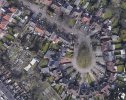
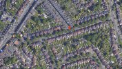
This is where CROFT ROAD enters CHURCH RD from Google street view Hmmm IT says the image file is too large for the server. But Google Street view has it. Not sure how to downsize the image? but it does show some commercial buildings at the junction of Croft Road and Church Road. this is up from the Yew Tree on Church Road going towards the Church. I do remember this Croft Road is a long road that winds around to Barrows lane then I would go down Barrows Lane to Moat Lane and my house I could email the photo I think if you give me an Email Address
Last edited:
Dont know if anyone remembers but i had an uncle that used to live on Church Road and operated a garage at the back of the house where he used to repair cars as a business, there was a gap in between the terraced houses where he used to take the cars to the rear garage. This would be in the 50,s and 60,s the approx location is about where Tesco filling station is now.Read with interest your comments on Church Road, my grandfather lived at 218, he also owned a cycle shop in the early 1950's in the same road. His name was William Linforth. His wifes parents (surname - Horsley) lived in Church Terrace - opposite St Edburgha's Church, also in Church Road Yardley. Wonder if you or others have any information on these.
His name was George Edward Stenson, and before him his father also repaired cars in the same location his name was Charles Leonard Stenson.
Dont know if anyone remembers them, maybe you had your car repaired.
He lived at 53 Church Road if anyone remembers, George Edward was sadly killed in a car accident in Burntwood in 1968.
Last edited:
Dennis Williams
Gone but not forgotten
Two more files for the location showing a filling station in 1940 and a motor engineers in 1963Yes this could be right, sounds logical enough. And with the garage that backs onto church road, by the first house on Croft road, the location of a filling station would be ideal for garage/motorists.
Not like we have much else to go by to be honest, or any photos of the lower end of Croft road - by the church road.
Thanks
Attachments
oldbrit
OldBrit in Exile
Itried to post photos showing the end of Croft rd and Church Road it said they were too big?Yes this could be right, sounds logical enough. And with the garage that backs onto church road, by the first house on Croft road, the location of a filling station would be ideal for garage/motorists.
Not like we have much else to go by to be honest, or any photos of the lower end of Croft road - by the church road.
Thanks
pjmburns
master brummie
Instructions to reduce image size here
 birminghamhistory.co.uk
Uploading Pictures
I want to and have tried to upload a few newspaper cutting from 1968 & 1992 that will be of interest to you all but it just keeps telling me that they are too big and I don't know how to make them smaller, any help would be appreciated :))
HiItried to post photos showing the end of Croft rd and Church Road it said they were too big?
I have not seen these. Could you try uploading again, or maybe sending them to me and I could try?
Thank you
suemalings
master brummie
According to mother in law it was a two pump petrol station at the end of Croft Road.


Does this web site show the photos of the petrol station you are thinking about?
 outercirclebus.com
THEN & NOW on the Outer Circle – stage 13
Having gone around the Tesco car park at the Swan, we join the dual carriageway that takes us to The Yew Tree – the original “commercial centre” in Yardley. There was at one time a yew tree standin…
outercirclebus.com
devonjim
master brummie
The garage in this web is on Stoney Lane just beyond "The Yew Tree!Does this web site show the photos of the petrol station you are thinking about?
THEN & NOW on the Outer Circle – stage 13
Having gone around the Tesco car park at the Swan, we join the dual carriageway that takes us to The Yew Tree – the original “commercial centre” in Yardley. There was at one time a yew tree standin…
According to Google Maps Streetview, 2022 the former petrol station is now called Grayson's Inn. I must say, seeing a photo of the building in its original form it did look rather charming. How easy it is to destroy the character of a building by removing the original features like window frames and chimneys.The garage in this web is on Stoney Lane just beyond "The Yew Tree!
Incidentally, to the left of it is a commercial building which used to be the Birmingham Co-operative Society which was the main large grocer in the area when I was a child. It seemed vast to me as an infant. You can still see the BCS plaque still on the front. The upstairs of the latter, Sue Malling told us, was used as a dance hall years ago and it was where the late Queen's coronation evening party was held in 1953, mostly for local adults. The Co-op would also use the room for promotional demonstrations and films. As a child, I was taken to see a film about a factory canning food, and another time, a demo of making a cake from a cake mix.
The main shop below was originally formal counters (maybe white marble) where, say, cheese would be cut by the assistant. For hygiene, a cashier would be in some sort of booth high up in the shop against the right hand wall, near the ceiling. The customer would put their money into a metal container and it would fly up to the booth via a pully contraption of some sort where the cashier would process the purchase and return any change. A dividend (or "divi") would also be applied, a bit like a loyalty card today.
Just to add a bit more fact Edward Stenson was married to a lady called Barbara and Len Stenson was married to Florence always known as Floss they all lived at 53 Church Road and Barbara had twins and named them Leon and Lester, just thought it might jog someones memory. Before moving to Church Road Len and Floss used to live at 96 Cranes Park Road.Dont know if anyone remembers but i had an uncle that used to live on Church Road and operated a garage at the back of the house where he used to repair cars as a business, there was a gap in between the terraced houses where he used to take the cars to the rear garage. This would be in the 50,s and 60,s the approx location is about where Tesco filling station is now.
His name was George Edward Stenson, and before him his father also repaired cars in the same location his name was Charles Leonard Stenson.
Dont know if anyone remembers them, maybe you had your car repaired.
He lived at 53 Church Road if anyone remembers, George Edward was sadly killed in a car accident in Burntwood in 1968.
have you been through this thread from post 1 as there could be a photo of the cottage...i dont know over that way very well so do not know if its still thereHi there , does anyone remember a cottage called jasmine cottage in Yardley old village ?
lyn
Dave the cyclist
Brummie babby
There was a small garage and petrol pumps on Croft Road it is now the site of houses the garage i think must have been demolished in the late 1960s early 1970s there was also a small builders supplies merchant at the side of a house on Church Road on the junction with Croft Road.