They're excellent photos Rupert. And they'll give Seabird a good idea of the road in the 1800s. In the 1970s I worked for a very short spell at the DHSS building on Bradford Street and all I can remember of it was as a very, very dark and depressing place. Quite forlorn and forgotton by that time. I suspect it was probably just before all these buildings were cleared. Looking on streetview I don't even recognise any of it, except the church (on Camp Hill I think). Viv.
-
Welcome to this forum . We are a worldwide group with a common interest in Birmingham and its history. While here, please follow a few simple rules. We ask that you respect other members, thank those who have helped you and please keep your contributions on-topic with the thread.
We do hope you enjoy your visit. BHF Admin Team -
HI folks the server that hosts the site completely died including the Hdd's and backups.
Luckily i create an offsite backup once a week! this has now been restored so we have lost a few days posts.
im still fixing things at the moment so bear with me and im still working on all images 90% are fine the others im working on now
we are now using a backup solution
You are using an out of date browser. It may not display this or other websites correctly.
You should upgrade or use an alternative browser.
You should upgrade or use an alternative browser.
Bradford street
- Thread starter Carolann
- Start date
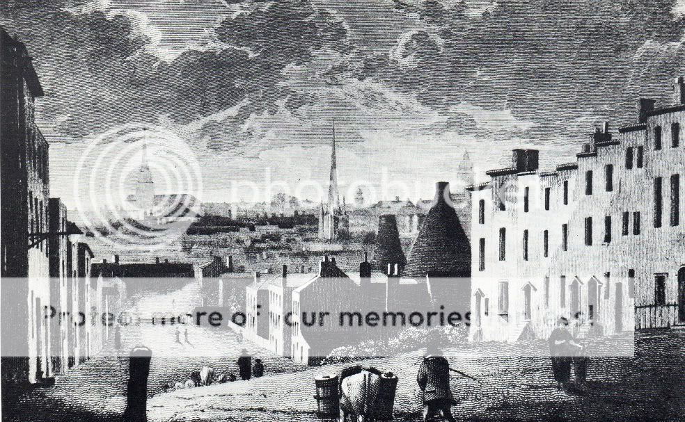
The 1783 drawing is also interesting as it shows what I recognize as two pottery kilns. I wonder what the history of them, or the pottery, might be?
Like Radiorails, I'd love to know what the two kilns on the right ( drawing in post #8) were for if anyone has any info. I did wonder if they were for bricks or could they be somethng to do with glass? Seem to vaguely remember similar structures being discussed on another thread, but can't remember where. Viv.
S
Seabird
Guest
Thanks Rupert - great photos. Just as I imagined they would have looked.
I wondered whether they could be glass kilns - they look similar to the ones at Stuart Crystal in Kingswinford.
I wondered whether they could be glass kilns - they look similar to the ones at Stuart Crystal in Kingswinford.
davidfowler
Exiled Brummie
Smashing comparison Lyn, thanks.
Would be hard to find a better line-up over time. The 1816 hill is steeper and perhaps this might give an indication of levelling down of the road that took place to reduce the slope, if the dates concur. Not sure what the kilns on the right were for...pottery, glass or some metal perhaps. This road would have led right to the bridge over the moat in your earlier post today. One is tempted to believe that there are trees in the distance that would have surrounded the old manor and could that be the old rectory to the left of them...nah..we just want it to be because we know they were there. I wonder if the toll gate is at the river Rae which I think was a boundary. Could that be Christ Church in the distance to the left. It would have been fairly new about then and perhaps the artist wanted to give a representation of it although it does not seem high enough on the hill and seems to be too large. Someone mentioned this before and thought I would highlight these points again.

Superb comparison Lyn. Rupert don't think we ever got to the bottom of what the kilns were for on the right. But I think we came to the conclusion that there had been some leveling of the road. We discussed it here: https://birminghamhistory.co.uk/forum/showthread.php?t=31693&highlight=Bradford+Street
There's a nice map that mikejee posted on that thread too showing the boundary. Such an interesting view.
Another memory i have of when I worked in Bradford Street was the stench from the abbatoir disgusting smell some mornings when you couldn't open the office windows!!. Viv.
There's a nice map that mikejee posted on that thread too showing the boundary. Such an interesting view.
Another memory i have of when I worked in Bradford Street was the stench from the abbatoir disgusting smell some mornings when you couldn't open the office windows!!. Viv.
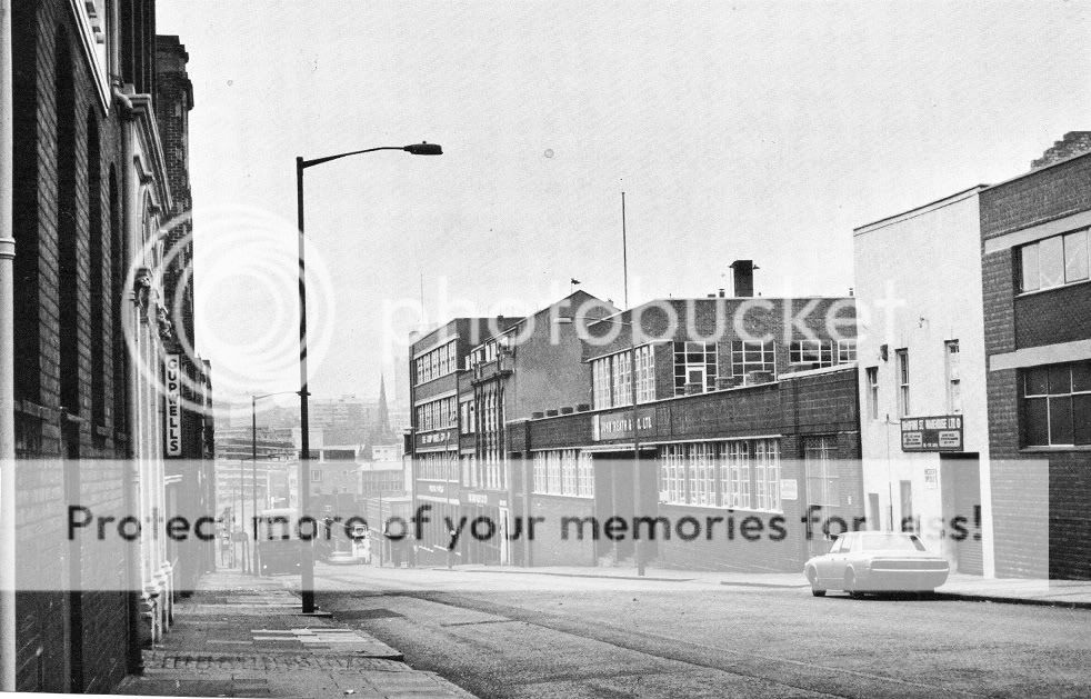
The building next to the car has survived almost intact - although the upper windows have been bricked up (window tax?).
I took a picture of this building about 5 years ago and it was unchanged then - I assume it is still there now.
View attachment 72952
Paul
It certainly does have cracking plaster! Viv.

PaulE
master brummie
Phyllis Nicklin took a photo from almost the same spot in the 1960's; I've magnified and stretched the middle bit to show the white buildings more clearly.
The one at the end had all its windows at that time (so much for my "window tax" theory) and was bare-brick. How curious.

Paul
The one at the end had all its windows at that time (so much for my "window tax" theory) and was bare-brick. How curious.
Paul
There was once a set of steps up to each of the houses too. The later photos show no need for steps. Would this be the result of the road levelling I wonder? Don't think I quite fully understand how the road was levelled now I think about it. Viv.
PaulE
master brummie
There were once steps up to each of the houses too.
Yes! But why didn't they build the houses at road level - surely that would have been easier than raising the road by 1 to 2 feet over the next 200 years! If you look on the other side of the road the buildings there are raised too.
The more I look at that drawing, the stranger it seems. I am sure it is accurate, though, because of the other details.
Paul
dek carr
gone but not forgotten
Maybe the area was subject to flooding the Rea was renown for it.DekYes! But why didn't they build the houses at road level - surely that would have been easier than raising the road by 1 to 2 feet over the next 200 years! If you look on the other side of the road the buildings there are raised too.
The more I look at that drawing, the stranger it seems. I am sure it is accurate, though, because of the other details.
Paul
Well it's becoming more and more baffling. If you go to the point on Streetview outside the house with the cracking plaster (it's just above Cheapside) and look down towards St Martin's the church is actually much, much further away in the distance than in the drawing. And like Rupert said in post#3, Christ Church looks very big in the drawing too. Very odd. Viv.
this thread is becoming very interesting but i think what we must realise is that the drawing i posted is only ones mans perspective..unlike a photo drawings and sketches are not always spot on...viv you could be right about the road being levelled off at some point but there again maybe the steep slope that shows in the drawing could have been exagerated by the artist..either way its one of my favourites...
lyn
lyn
Since the following draft was 1805...perhaps the soil had already been removed from the hill here and maybe this was the reason for the steps to the doorways. There also seems to be a rise to the doorways of the buildings on the left. Actually the whole area must have been lowered over time otherwise the road would have been in a gulley.
(Agree Alan. It would be interesting to find out more about the kilns. They wouldn't be brick kilns would they? Also, Neville's suggestion in post #13 about the slope of the road was correct! Here's an extract from Langford's 'A century of Birmingham Life'. It says: "October 21 1805. It gives us pleasure to observe the great improvements which are making in Bradford-street, by removing the hill at the top and carrying the soil to the lower part thereof. We think it proper, however, in order to prevent accidents, to recommend travellers and the public in general to avoid passing with horses or carriages along that part of Deritend till a safe and secure road is completed" Viv. )
The 1890 Ordnance Survey Map shows brass and iron foundrys on the right. You did this all before Viv. I just could not remember who posted this...just the fact that it had been. I think that the 1817 picture was indeed further down the hill than we have been thinking and camara lenzes focal length distort the appearance of distance. Maybe from about Birchall Street.
I remember posting the info about the road being levelled but couldn't make sense of why the level is much higher in the modern photos, especially if (Paul's post #4) white house is one of those shown in the early drawing. The road seems to have risen substantially in modern times. Rupert I'm sure you're right that it does seem to point to the drawing being from a position lower down. Also Dek's point in post #13 could be an important factor perhaps too i.e. take the soil from the top of the hill to bank up the lower part? But not being a civil engineer I have no idea if this is a feasible solution to the flooding issue!! Don't remember the conclusion about the kilns, however - must be losing it!! Viv.
PaulE
master brummie
I've dug out a 1731 map of the area; from the name of the road "Brickhill Rd" it seems likely that they were brick kilns.

Could the side of the hill have been excavated to make bricks? And after Bradford St was built the houses were constructed in the knowledge that the road level was going to be raised, using material from the top of the hill, as indicated in the other thread.
Paul
Could the side of the hill have been excavated to make bricks? And after Bradford St was built the houses were constructed in the knowledge that the road level was going to be raised, using material from the top of the hill, as indicated in the other thread.
Paul
PaulE
master brummie
Thanks Lyn
I love looking at old maps. Show me a Victorian map of Brum and I could imagine walking the streets without getting lost. I know what the old buildings look like, and I could almost imagine dropping in on my gt gt grandfather in Cheapside, for example.
But this one takes us back to a world 300 years ago that would seem strange even to him! Even North isn't where you would expect ;-)
Paul
Makes perfect sense Paul. Now you must forgive me if this turns out to be a red herring, but I also notice on mikejees 1839 map on post #15 in the earlier thread, there's a circular building just above the first 't' in (Bradford) Street. Could this be one of the kilns? Here's the link again for quick ref. https://birminghamhistory.co.uk/forum/showthread.php?t=31693&highlight=Bradford+Street Viv.
PaulE
master brummie
Well Viv, I am certainly not an expert on these things but I think there is a good chance it is! Perhaps it is an old building which is now being used for something else?
I've found another old map, 1819 this time.

It seems Brickhill Road evolved into Birc Hole St (maybe via Brick Hole Road?) before becoming the Birchall St we know today.
Regards
Paul
I've found another old map, 1819 this time.
It seems Brickhill Road evolved into Birc Hole St (maybe via Brick Hole Road?) before becoming the Birchall St we know today.
Regards
Paul
Good map Paul. By looking at the maps it's just struck me that brick making is more and more likely. The River Rea is close, so I'm thinking clay deposits, which leads me to bricks. No need for huge investment in transport as it's virtually on tap. Lyn and Paul - Who needs a time machine when you've got imagination?!! Viv.
Having said all that in post #24, is this 1858 plate significant I wonder? Viv.
.
.
PaulE
master brummie
I don't know, maybe Mike could locate that building on his map? It could be an old building re-used.
Also:
Wood-cutting, joinery, charcoal-burning, saddlery, and metal-working were the ancient trades of Deritend and west Bordesley. As the timber dwindled, clay took its place as building material. Small kilns on Bordesley farms gave way to large brick works in Victorian times
https://www.bgfl.org/bgfl/custom/re...ry/jm_jones/aston_manors/bordesley/page25.htm
Paul
