-
Welcome to this forum . We are a worldwide group with a common interest in Birmingham and its history. While here, please follow a few simple rules. We ask that you respect other members, thank those who have helped you and please keep your contributions on-topic with the thread.
We do hope you enjoy your visit. BHF Admin Team -
HI folks the server that hosts the site completely died including the Hdd's and backups.
Luckily i create an offsite backup once a week! this has now been restored so we have lost a few days posts.
im still fixing things at the moment so bear with me and im still working on all images 90% are fine the others im working on now
we are now using a backup solution
You are using an out of date browser. It may not display this or other websites correctly.
You should upgrade or use an alternative browser.
You should upgrade or use an alternative browser.
Bomb damage photos of WW2
- Thread starter philbee
- Start date
Phil
Gone, but not forgotten.
Here are a couple of bomb plot maps, I'm afraid they are very low resolution so you would be unable to enlarge the much bigger than they are, but they give a general idea of how many bombs dropped and where.
Attachments
![bombmap[1].jpg](/forum/data/attachments/6/6515-3ae597080271b64eb65478ddd23dd4ed.jpg)

Phil
Gone, but not forgotten.
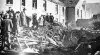
A couple of photos of the bomb damage in Vincent Street, Balsall Heath. These bombs dropped only yards away from my grandparents house. I have often looked at then to see if I can recognise anybody, but alas there is nobody who even looks familiar. Save for the one chap who looks like Hitler, perhaps he popped over to see how his bombers were doing.
The modern photo shows the maisonettes that were built in place of the school, but St Paul's School was never rebuilt, I believe that to be the large building that can be seen over the roofline in the one photo.
The modern photo shows the maisonettes that were built in place of the school, but St Paul's School was never rebuilt, I believe that to be the large building that can be seen over the roofline in the one photo.
Attachments

hi phil
any ideas when tat photograph was taken ;?.
when i was young my first wife lived in the very bottom of the pic the massonete on the left hand side as fa as you can see;
she moved into there when we got divorced she lived there for years ;i was around ther many years ago that far back i cannot recall the year
i still see her from time to time as she lived still around the balsall heath area
i think the avenue as been shortenend now ;its not as long as it was nor as many maisonnettes but her s is still there ;
it was a good picture taken phil ;did you take it your self ;? alan ; astonian;;
Phil
Gone, but not forgotten.
Astonian I don't think the maisonettes were built until after the end of the war around the time that I was born c1947. In fact the Rose & Crown public house which caught the edge of the blast was still using the bottle stores in the back yard as the pub until at least 1951-2. The photo is taken from Google Earth as would you believe it, although I have some that I have taken I am unable to locate them at the moment. The last time I was down that way Tanworth Grove & Lapworth Grove on the other side of the road looked the same as they have always done.

Stephen0002002
master brummie
Yes you can see that on google maps now. Interesting rebuild looks like nothing ever happened.
hi carolina
just read your thread on the bombing pictuire ; have you got the same book as me ; i was in worcestshire city this morning and i have just picked up
a book full of bombed brum its full of pages of all over a city when it was bombed
Its called birmingham at war a pictorial account by alton douglas and printed in1982 and produced by the birmingham post and mail publication
i shall be taking and down loads of them .
keep them coming carol best wishes astonian;


sistersue61
master brummie
Is the Vincent Street in post 34 the same one that is classed as Sparkbrook in the 1939 electoral rolls? The reason I ask is that mom was bombed out from Vincent Street Sparkbrook in 1940 and looking at the poics, I think I can spot my nan and Uncle Stan on them - they lived at 90 Vincent Street, seems a bit of a coincidence and I can't find another Vincent Street in Brum.
Sue
Sue
Phil
Gone, but not forgotten.
Sistersue
I know it has been a long time in answering this query, but I have only just seen it. Yes I think Vincent Street came under Sparkbrook in the electoral rolls, well Percy Shurmer was our MP and he represented the Birmingham Sparkbrook constituency. I believe that the only other Vincent Street in Birmingham was St Vincent Street in the Ladywood area.
I know it has been a long time in answering this query, but I have only just seen it. Yes I think Vincent Street came under Sparkbrook in the electoral rolls, well Percy Shurmer was our MP and he represented the Birmingham Sparkbrook constituency. I believe that the only other Vincent Street in Birmingham was St Vincent Street in the Ladywood area.
Hi Phil
What year are you thinking of regarding spark brook unless there was one ,the only one I can recall is or should I say it was in Ladywood
I also recall shurmer as well unless some one like mike as got a map of old spark brook because Ladywood is a good distance from
Spark brook there is Lee bank seperating from Ladywood then high gate and then in the old records of boundrys was known as balsall heath
And spark brook is way yo under from the Stratford rd and stone lane and Walford red end coming back to the city was spark hill
And spark brook then deritend. ,digbeth back to Bradford street and broad street then Ladywood
And Vincent street was between sheepcote street and old Ladywood rd and still is
Have a nice day Phil astonian,,,,
sylviasayers
master brummie
In my old Wakelin's Street Guide there is only one Vincent Street, running from 425 Moseley Road to Wenman Street, B12.
There are also Vincent Parade , off 292 Balsall Heath Road, and Vincent Crescent off 270 Balsall Heath Road. B12.
There are also Vincent Parade , off 292 Balsall Heath Road, and Vincent Crescent off 270 Balsall Heath Road. B12.
Phil
Gone, but not forgotten.
Alan
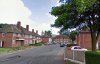
I mentioned St Vincent Street Ladywood, but I think the only Vincent Street was in Balsall Heath which was in the Birmingham Sparkbrook Constituency. Which can be seen here running from Moseley Rd to Edward Rd, part of this street remains today in name only.
I mentioned St Vincent Street Ladywood, but I think the only Vincent Street was in Balsall Heath which was in the Birmingham Sparkbrook Constituency. Which can be seen here running from Moseley Rd to Edward Rd, part of this street remains today in name only.
Attachments

Hi sylvi
What years is your wakelin book you can restasured there was more than one vincent street as we say there was one in Ladywood and is still there for hears
Our kid lived down the bottom of it in light thorn avenue until he died a couple of hears back his kids and is wife my sister in law
Still live down there and today they nick named gun slinger alley and Vincent street today is very undesirable to street to walk at most time
During the day yet alone at evening you would not want to risk walking after darkl
And I recall Vincent street from my school days before they rebuilt I am just trying to replace in my mind where about this Vincent street is or was
As I used to repo houses for certain estate agents on mosely village and for building Societys which was on mosely village on mosely road
And balsall heath road crosses as I think about it there may have been one further along back down on the opersite side of the mosely road baths
There was a little church or school and a company that does transverse and sticker possibly called globe transverse
Have a nice day best wishes. Alan. ,,,,astonian,,,,

sospiri
GONE BUT NOT FORGOTTEN
I can't help you with Vincent Street, but I lived next door to the Knowle Road bomb site - three months AFTER the bomb fell!
A great play site - lots of materials with which to build dens. The Anderson shelter in the back garden was permanently flooded so we were on duckboarding above about two feet of water. But even that seemed better than sitting out a raid in my grandmother's coal cellar!
Maurice
A great play site - lots of materials with which to build dens. The Anderson shelter in the back garden was permanently flooded so we were on duckboarding above about two feet of water. But even that seemed better than sitting out a raid in my grandmother's coal cellar!
Maurice


Phil
Gone, but not forgotten.
Alan
When I was about 6 years of age I wandered off from my grandmothers house in Vincent Street, after wandering around for hours I walked in to a hairdressers shop and asked for directions to Vincent Street. Believe it or not I was in St Vincent Street and it took for ages to convince a gathering crowd that it was another Vincent Street I was looking for. Thankfully the hairdresser called the police and I was returned to my mother after a short but thrilling ride in a police car.
When I was about 6 years of age I wandered off from my grandmothers house in Vincent Street, after wandering around for hours I walked in to a hairdressers shop and asked for directions to Vincent Street. Believe it or not I was in St Vincent Street and it took for ages to convince a gathering crowd that it was another Vincent Street I was looking for. Thankfully the hairdresser called the police and I was returned to my mother after a short but thrilling ride in a police car.
Hi Phil
I most certainly can believe you because that area as change dramicly especially the streets all those pure war house was demolished
Right across Ladywood monument rd right up through Ladywood and through to broad street and through and down to sun street west Lee bank
Lesam street and the old picture house virtually all the building in fact of Ladywood as kids we tattered all those old houses
That ever stood in Ladywood and after the war searching for any helmets gas masked lamps we found loads of things
You name we was in there down these cellar. In fact there I have seen every part of Ladywood change step by step street by street
Right through to the city believe or not seen the shops and
Pubs and factories disappearing bit by bit and as for the small king Edwards rd where we was brought up and the surrounding streets
Its beyond beggers belief if some of our forum member went back that area meaning Springfield street stout street more so
And the st marks street and beyond down to the city up to the nia they would not believe they are seeing
And say what on earth was all that mess for a complete bodge desicrated the area
Any way Phil I will not waffle on I surprise we have to take it or lump it ASD the old saying goes and they call it progress
Well if you weren't to little king Edwards red and more so stout street I think one would scream
Yes all those pure war houses when you walked down and around all looked the same to a stranger in the street
Thanks again Phil for pointing out maybe the saint. Bit was add years later Alan,, astonian,,,,,,
Alan
The street in Ladywood was Saint Vincent Street, not just Vincent Street.
Interestingly however, BOTH Vincent Streets (in Ladywood-post 51-AND Balsall Heath) have a "Tindal Street" of one kind or another in their immediate vicinity.