B
-
Welcome to this forum . We are a worldwide group with a common interest in Birmingham and its history. While here, please follow a few simple rules. We ask that you respect other members, thank those who have helped you and please keep your contributions on-topic with the thread.
We do hope you enjoy your visit. BHF Admin Team -
HI folks the server that hosts the site completely died including the Hdd's and backups.
Luckily i create an offsite backup once a week! this has now been restored so we have lost a few days posts.
im still fixing things at the moment so bear with me and im still working on all images 90% are fine the others im working on now
we are now using a backup solution
You are using an out of date browser. It may not display this or other websites correctly.
You should upgrade or use an alternative browser.
You should upgrade or use an alternative browser.
horsencart
master brummie
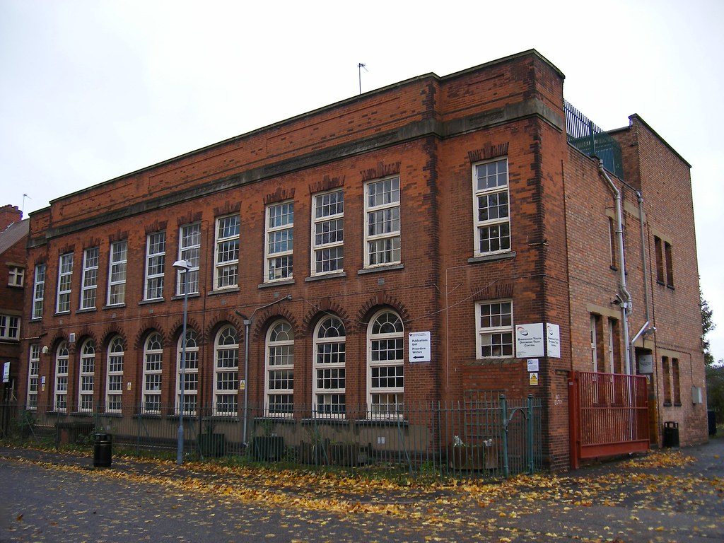
It used to be a car show room it does not appear in the 1975 directory, is it just that building or is it what was on the site before? I assume that you have had a look at Google earth maps for Blucher St ?
UOTE=Bernie D'Boult;480593]Hi Following search for Blucher Street I came across this (and other) photos of Brum on Flickr. Advice on the building in the foreground of this one is requested. Perhaps some forum members could provide this? If you do not have a Flickr account then let me know and I will add them.[/QUOTE]
UOTE=Bernie D'Boult;480593]Hi Following search for Blucher Street I came across this (and other) photos of Brum on Flickr. Advice on the building in the foreground of this one is requested. Perhaps some forum members could provide this? If you do not have a Flickr account then let me know and I will add them.[/QUOTE]
B
BernardR
Guest
Hi - No I hadn't but will. By the way your link needs checking:friendly_wink:
Here is the question as asked - [h=1]Blucher Street, Lee Bank[/h]Lovey shot of Holloway Circus and the two huge tower blocks overlooking this view. Though need help identifing the small building facing this viewpoint by the corner of Gough Street.
Can any Birmingham locals help?
Here is the question as asked - [h=1]Blucher Street, Lee Bank[/h]Lovey shot of Holloway Circus and the two huge tower blocks overlooking this view. Though need help identifing the small building facing this viewpoint by the corner of Gough Street.
Can any Birmingham locals help?
As I remember it the building was some kind of factory/office unit although I can't remember the name of the company. I tried looking at the building closer on Google StreetView and it shows a sign saying that two parking places belong to a company although the name is unreadable. That is on the Blucher Street side. On Gough Street, google gives the address as 29 Gough Street. One of the glass doors has 31 Gough Street etched into the glass by the handle. Another search gives 31 Gough Street as the address of the United Services Club. As I remember it their place was a little further down the hill on the other side and is now a banqueting suite and a rock club at weekends.
Singers Hill synagogue, in blucher St, at its opening in 1856. Still looks the same, as can be seen in Ellbrown's photos on post 39 at https://birminghamhistory.co.uk/for...gham-mailbox-building.9675/page-2#post-370331.


Radiorails
master brummie
Conveniently close to the synagogue, in the next block. Not far for the children to go on high days and holy days.
yes alan..synagogue still there as seen in post 6 oops sorry mike just noticed you have already posted a street view
https://www.google.co.uk/maps/@52.4...4!1sO8S6HdM3BYc1hJG3WAgKxQ!2e0!7i13312!8i6656
https://www.google.co.uk/maps/@52.4...4!1sO8S6HdM3BYc1hJG3WAgKxQ!2e0!7i13312!8i6656
ellbrown
ell brown on Flickr
Singers Hill synagogue, in blucher St, at its opening in 1856. Still looks the same, as can be seen in Ellbrown's photos on post 39 at https://birminghamhistory.co.uk/for...gham-mailbox-building.9675/page-2#post-370331.
View attachment 127892
They have renovated inside since there 160th anniversary. Upstairs no longer used by women as congregation is smaller (they sit downstairs behind a railing).
Security fences outside. Car park is now rented out I think during the week.
The Joseph Cohen Hall is pretty much the same inside.
ellbrown
ell brown on Flickr
The last Hebrew School used to be on that St Lukes land but was recently demolished. Later known as the Highgate Centre.
King David School has been open since the mid 1960s on the Alcester Road in Moseley (there is also now a synagogue for the much reduced Moseley community on what was the site of the swimming pool).
King David School has been open since the mid 1960s on the Alcester Road in Moseley (there is also now a synagogue for the much reduced Moseley community on what was the site of the swimming pool).
Williamstreeter
master brummie
Hi Following search for Blucher Street I came across this (and other) photos of Brum on Flickr. Advice on the building in the foreground of this one is requested. Perhaps some forum members could provide this? If you do not have a Flickr account then let me know and I will add them.
BernardR I don't have a flickr account
Williamstreeter
master brummie
I worked at Walsall Conduits in Upper Gough St 1969-71 , I was aware of the Synagogue which I walked past everyday. I had no idea about the school, as someone has remarked I remember it being a car showroom at that time
Hi Mikejee, i saw you had posted a close up map of 37 Blucher st, is it possible to give a link to the map so that i can check it out towards the bottom of the road too ? someone is looking for 2 back of 57 blucher stWilliam
I don't think anyone here is likely to remember it as a school. Ut stopped being marked in directories in 1933, and on maps it was just marked as a
hall till around the 1960s
that would be wonderful thank youi have 7 photos of this street if anyone would like to see them ?
lyn


oh thank you, picture 1 is the Craven Arms, with the sweet shop next door, on the left of the picture you can just see the R Whites sign for Joe Rann's shop, groceries and sweets, we lived next door to that one . oh my goodness photo number 7 I believe this is my back yard!! the door at the end facing is number 20 Blucher st, and was from Joe Rann's corner shop, we were next door at number 21 then 22 then an alley way through to the yard. On the left is the toilet block and brewhouse/washhouse.. I don't recognise the other photos but I will send them to my brother, I am sure he will. oh thank you so much
Last edited:
The map was from the old maps site (https://www.old-maps.co.uk/). The map for the whole street (c1950) is below, but no use to you as the area containing no 57 has by then been flattened. However I have attached a map c 1889 where I have marked no 57 in red, and court 4 (which is the same as back 57) with red marker. Cannot be certain which is back house no 2 of 57, but suggest it might be the one in blue,. But this is only a guessHi Mikejee, i saw you had posted a close up map of 37 Blucher st, is it possible to give a link to the map so that i can check it out towards the bottom of the road too ? someone is looking for 2 back of 57 blucher st

oh thank you, picture 1 is the Craven Arms, with the sweet shop next door, on the left of the picture you can just see the R Whites sign for Joe Rann's shop, groceries and sweets, we lived next door to that one . oh my goodness photo number 7 I believe this is my back yard!! the door at the end facing is number 20 Blucher st, and was from Joe Rann's corner shop, we were next door at number 21 then 22 then an alley way through to the yard. On the left is the toilet block and brewhouse/washhouse.. I don't recognise the other photos but I will send them to my brother, I am sure he will. oh thank you so much
so pleased they mean so much happy to help
lyn
Many thanksThe map was from the old maps site (https://www.old-maps.co.uk/). The map for the whole street (c1950) is below, but no use to you as the area containing no 57 has by then been flattened. However I have attached a map c 1889 where I have marked no 57 in red, and court 4 (which is the same as back 57) with red marker. Cannot be certain which is back house no 2 of 57, but suggest it might be the one in blue,. But this is only a guess
View attachment 149616
Hi - does anyone have any old photos of Blucher Street? Or information on the shops/premises along there in the early to mid 1900s? My G-Grandfather had a shoe shop there around the mid 1920 - 1930s - he was Walter Wilson and called himself a Boot and Shoe Factor. He was somehow linked to the Wassals shoe shop family but I'm not sure how. His shop was not a Wassals shop, however. Thank you ")
Williamstreeter
master brummie
Singers Hill synagogue, in blucher St, at its opening in 1856. Still looks the same, as can be seen in Ellbrown's photos on post 39 at https://birminghamhistory.co.uk/for...gham-mailbox-building.9675/page-2#post-370331.
View attachment 127892
Working in Upper Gough St in the late 60's early 70's . I did notice that the car park used to fill up very quickly on Saturday morning . This was due to worshippers going to the synagogue , as their religion states they must walk to worship .
If you were a Girl Guide or Brownie in the area in the mid 1960s you might be in this photo taken inside Blucher Street Hall. Viv.

Source: British Newspaper Archive
Source: British Newspaper Archive
We lived at number 38 Blucher street opposite the synagogue till June 1965 I believe the shop next door to Craven arms is Dimwiddysoh thank you, picture 1 is the Craven Arms, with the sweet shop next door, on the left of the picture you can just see the R Whites sign for Joe Rann's shop, groceries and sweets, we lived next door to that one . oh my goodness photo number 7 I believe this is my back yard!! the door at the end facing is number 20 Blucher st, and was from Joe Rann's corner shop, we were next door at number 21 then 22 then an alley way through to the yard. On the left is the toilet block and brewhouse/washhouse.. I don't recognise the other photos but I will send them to my brother, I am sure he will. oh thank you so much
RobT
Acemeccanoman
In 1955 Kelly'sWe lived at number 38 Blucher street opposite the synagogue till June 1965 I believe the shop next door to Craven arms is Dimwiddys