-
Welcome to this forum . We are a worldwide group with a common interest in Birmingham and its history. While here, please follow a few simple rules. We ask that you respect other members, thank those who have helped you and please keep your contributions on-topic with the thread.
We do hope you enjoy your visit. BHF Admin Team -
HI folks the server that hosts the site completely died including the Hdd's and backups.
Luckily i create an offsite backup once a week! this has now been restored so we have lost a few days posts.
im still fixing things at the moment so bear with me and im still working on all images 90% are fine the others im working on now
we are now using a backup solution
You are using an out of date browser. It may not display this or other websites correctly.
You should upgrade or use an alternative browser.
You should upgrade or use an alternative browser.
Birmingham Skyline
- Thread starter pollypops
- Start date
oldMohawk
gone but not forgotten
Susan shaw
master brummie
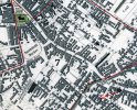
Viv, I love this photo. I have only just mentioned the Birmingham Post and Mail in another post. I had lots of family working there, including my dad. After getting married I decided to do agency work, as we needed a deposit for a house. I worked for SOS Bureau, based in the Rotunda on the 6th floor. My second assignment was at the Mail in the Accounts department!! More happy days. Thank you Viv.An aerial view which appeared in an Evening Mail Supplement in September 1970. Colmore Row and Steelhouse Lane run diagonally - left to bottom right. The Post and Mail building is in the centre of the view. Viv.View attachment 153665
SteveBhx
master brummie
So the year I was born thenYes, I had 1964 in my head too.
Interestingly you photo contradicts the construction method we were all taught at college.
Thanks Viv, so do you thik thats the Rotunda on the left?A photo in the Geoff Thompson Archive claims Manzoni Gardens (on the site of the old Market Hall) were being laid out in early 1964. Viv.
Last edited:
Pedrocut
Master Barmmie
Not come across many photos of the Exchange interior. Not much to see of it in the photo but nice to know there are some around. Thanks Pedro. Viv.
Radiorails
master brummie
Oh! my, how the Town Hall stood out in that drawing. Not like today where it is somewhat hemmed in!
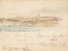
This print is from a 1797 drawing by W. Turner. I vaguely remember having a discussion about those crossed poles (not about this drawing, but they feature in another) but can’t find that discussion. I don’t think we came to any concrete conclusion about the poles.
Is the church extreme left St John’s ? Or is it too far away ? Can quite get my bearings.
Viv.

Is the church extreme left St John’s ? Or is it too far away ? Can quite get my bearings.
Viv.

I think the frames are Tenters, used to fullers to stretch cloth after fulling (https://en.wikipedia.org/wiki/Fulling) . Westleys 1731 map shows frames, which I believe are those, though shown a different shape on the panorama, but that was a few years later . The 1777 Directory shows a dyer at 84 Park St, which I think would about fit with the map and the panorama. Below are photos of some frames in the early 20th century and what are believed to be the last remaining frames at Otterburn


Banjo
master brummie
Do you think that man & his dog are walking down what we now know as Garrison Lane?
The following images show what I rethink might be manufacturing kilns or cones in the distance beyond the Bull Ring. The first one dated 1830 shows a kiln-type structure to the left of St Martin’s Church. The second shows a kiln-like structure - 1848 - in a similar position.


Some while back on the Bradford Street thread we discussed what some nearby kilns were being used for. The discussion arose out of an image showing two kilns on/near Bradford Street in the 1783 drawing below. Could these be the very same kilns ?
In their time they must have dominated the skyline, but all traces have long gone. We debated whether these were for brick-making, glass-making, wrought iron enamelling or glass enamelling, but were unable to come to any definite conclusion. The kilns were there for at least fifty years, seems a shame we don’t know a little more about their significance in the area. One possibility was the business in the advertising card below, but this may have been one of a number of different processes over time, changing with technology and manufacturing methods. It’s possible it started out with another purpose. Viv.


Last edited:
Thanks Mike. I agree, there seem to be anomalies here I think. The structure in the 1830s drawing looks oversized, and therefore may give an illusion of nearness. The 1848 one looks closer to Holy Trinity Camp Hill, but that too could be an allusion. And of course, the drawings could well be inaccurate I suppose. We can’t even be 100% sure the structures are actually kilns in the first two images either. So the jury’s out on this one I suppose. Viv.
Last edited:
This 1870 view shows, I think, Aston Hall and Aston Church. The piece is titled The View of the City of Birmingham After Peter de Wint. But from where would this view have been captured ? Sutton Park ? Oscott ? Or somewhere nearer to Birmingham. within the trees to the left are hedges (?) which look almost landscaped. Although sheep are grazing, it looks like land is open and used for recreation. Viv.


SteveBhx
master brummie
Bit late, is that that where the multi storey car park is?A 1974 view of Birmingham. Viv.View attachment 177836
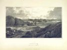
This is A View of Birmingham from Meyers Universum 1840. (This was a book of topographical engravings published, I think, in Germany ?).
Although the view has been posted before, I think there's an interesting comparison with the coloured version. So much more detail seems to stand out in the coloured version.Viv.
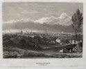
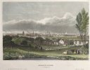
Although the view has been posted before, I think there's an interesting comparison with the coloured version. So much more detail seems to stand out in the coloured version.Viv.


Last edited:
Radiorails
master brummie
The coloured version shows off the chimneys and the smoke emissions making the black cloud more relevant. 


