Posted the last post before seeing your post. This photo was taken directly after the previous 3. As far as I can see it must have been taken along Balfour st, and I can't see myself going away , and then coming back (though it is possible), and surely the mount Pleasant school is at the wrong position for it to be Gosford St, though you know far more than me about the area obviously.
-
Welcome to this forum . We are a worldwide group with a common interest in Birmingham and its history. While here, please follow a few simple rules. We ask that you respect other members, thank those who have helped you and please keep your contributions on-topic with the thread.
We do hope you enjoy your visit. BHF Admin Team -
HI folks the server that hosts the site completely died including the Hdd's and backups.
Luckily i create an offsite backup once a week! this has now been restored so we have lost a few days posts.
im still fixing things at the moment so bear with me and im still working on all images 90% are fine the others im working on now
we are now using a backup solution
You are using an out of date browser. It may not display this or other websites correctly.
You should upgrade or use an alternative browser.
You should upgrade or use an alternative browser.
birmingham 1969-73
- Thread starter mikejee
- Start date
Williamstreeter
master brummie
No 21. This seems to be the delivery entrance to Furbers in Alston Street. Looking at the 1914 map, there was probably quite a large area available for hearses.
22. This looks a bit like an old style doctors surgery, and that is what it was from about 1936 to 1966, occupied by Mr (must remember that as he was a surgeon and not one of the hoi-polloi medics) Reginald Abrahams. Before that it was occupied by, among others, an artificial teeth maker and the Misses Fearn ,teachers of music.
3, 23 and 24. These are of Rann St,, the last being a shot from one direction looking down to a fish & chip shop at the end, the first in the other direction, and the middle one, a section of the houses.
Note added by member Jabaprawn :"pictures 23 and 24 i could be wrong.. rann st,. with rann st chippie at the bottom. walked past these houses on my way to school (oratory school,oliver road"
26. Monument road baths before their demolition.


Monument Rd Baths , while at St Peters off Broad St we went here , strangely enough thinking back it always seemed to rain when our class went here . Nothing like not drying yourself properly and walking back to school in the rain. In the school holidays it was different though the odd rainy day , but mostly good days , then out of the pool for a cup of either Oxo or hot chocolate and a packet of cheesettes . That's what I call living , perhaps a game of tracking or cowboys on the way home
Williamstreeter
master brummie
john you can still get cheesettes")
Would'nt be the same, now the baths have gone
The next three photos connect and show a row of houses . They were taken immediately after the previous ones , and examining the arrangement of the houses (with breaks and the covered passageway in the first photo), together with the area being photographed, I am pretty convinced that they show nos 3-13 Balfour St (in red on the map)


Radiorails
master brummie
Some of the Lincoln Street posts, appear to show the centre of the road surface being a light colour probably where the single track tram lines were. The 39 tram route was abandoned in October 1949. The inward, city bound trams would run from Mary Street, into Balfour Road and thence Lincoln Street then onward to the city. The Balsall Heath tramway system possessed many single tracks in which trams travelled in one direction only.
Last edited:
Alan.
If you look closely the lighter areas seem to be structured (cobbles/stone setts/wooden blocks), whereas the darker areas are not and look like tarmac. Isn't it more likely that the dark areas were where the lines were removed and quickly filed with tarmac?
If you look closely the lighter areas seem to be structured (cobbles/stone setts/wooden blocks), whereas the darker areas are not and look like tarmac. Isn't it more likely that the dark areas were where the lines were removed and quickly filed with tarmac?
Radiorails
master brummie
My pc picture does not seem to show setts in the centre of the road, where the track would have been, Mike. However, the tracks were in the centre of the road and you could not lift the tracks one at a time as they were connected by lateral stretchers so the whole lot had to be lifted at the same time. This could explain the size and location of the infill.
Incidentally there is a photograph of Balfour Street in one of my books which shows sets between and either side of the tracks. However, the photo is pre-war as it shows a gas lamp (with white top) and the open balconied car has an ornate fleet number.
It might be that the setts either side of the track have been tarmacked over. The traction poles for the overhead were on the same side as that showing the bus stop.
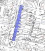
The following set of photographs show the houses down the east side of Lincoln St from 58 down to 35, and with a side view of the wall of the Woodman pub on Edward St. The houses are marked in blue on the map. At highest resolution, and knowing what is behind, the plaque on the wall between 56 & 57 can just about be made out to read Woodbine Place. the houses are shown in blue on the map below
The last owner in Kellys of "Tony's Cafe" at no 56 is F.H. Farnham, and the electoral roll shows not mention of an Anthony or Tony at that address. In the 1940s and 50s it had beena fried fish shop
For a short time till demolition, at no 50 Mary Cooper had a drapers shop.
At 47, with the Stephens Ink sign , the last occupant was H Sojka, a grocer, and previously in the 1950s it had been Edward Solarz, another grocer, but in th e1940s the shop had been occupied by Gilbert Barnes, a newsagent, and this is probably where the sign came from.
The first of the set go from nos 58 to 44
Attachments
Last edited:


Radiorails
master brummie
Mike I was a little confused with the photos, viewing them on a laptop maybe. The road was not Balfour Street but Lincoln Street that caught my eye.Alan.
If you look closely the lighter areas seem to be structured (cobbles/stone setts/wooden blocks), whereas the darker areas are not and look like tarmac. Isn't it more likely that the dark areas were where the lines were removed and quickly filed with tarmac?
Anyway great photos to be sure.
I note in your circa1954 map the tramway is no longer shown.
The following two photos run together and were taken at the same time as the last ones, and must be in the same area. I did at first think they might be taken from behind nos 35-38, but am very doubtful of this, even allowing for changes that may have occurred since the map of c1954


Phil
Gone, but not forgotten.
Mike,
As I suggested a few years back I think the last two photos were of the rear of the once bicycle factory that was in Court Road, You were probably in a back court on Lincoln Road looking at the rear of the factory when you took the photo, there was one down an entry by the bus stop we discussed and if I remember correctly there was a dry cleaners at the top of the entry.
In the photo that I am attaching the factory in question is on the centre right, by the time of your photos it had been divided up into separate units.
Last edited:
Thanks Phil. Some years ago i lost all my e-mails (including early ones from you) and that included those where you commented on the photos. (stupidly I had not backed them up). that certainly fits, and would make the partly demolished houses in the photos those marked in blue and the single story dark-roofed building the building in red.


This photo has been in Carl's magazine, but not previously on the forum. It shows two houses, 90 Balsall Heath Road and 28 Princess Road. Although Balsall Heath Road is a much older road, dating from 1829, these houses are somewhat younger,being built in the late 1870s.
No. 90 (then 67 before renumbering) was first occupied by Henry Ashton, shortly after by his daughter, Marie, and then by Edward Philemon Timmins, a mechanical engineer, which in those days meant someone of high status. For about seven years around 1900 the building was the home and workplace of William Johns, Professor of Music. At that time this description meant only that he was a music teacher, in this case of the piano, not someone with a university post. He was the late-born son of the licensee of the White Swan in Islington Row, who left his wife well enough off to enable William to pursue his profession first in Islington Row, then here and finally opposite the Queen's Hospital (later the Accident Hospital) in Bath Row. From the late 1920s till 1960 it was occupied by the Whiles family, who had a business in Caroline Street, but after that the occupants of the house changed almost yearly, and, despite the dereliction, it can still be seen that once it was a desirable residence.
The attached 28 Princess Road was first occupied by William Picton. He was a partner with his father Charles and brother Charles, in the firm of Picton & Sons, canal carriers, coal merchants and wharfingers, with bases at Birmingham Wharf, Monmore Green in Wolverhampton and at Crescent Wharf, off Cambridge Street in Birmingham. The company had been going from the 1860s and the main trade seems to have been cargoes from Wolverhampton to Birmingham and around that area. In 1882 the partnership was dissolved and George seems to have carried on the business himself, adding deliveries by road to what was then called Picton & Co. The company was prosecuted several times for cruelty to the horses pulling the delivery carts, though this would have been more the fault of his employees than him and seems not uncommon at the time though often brought to light by the efforts of the RSPCA, which was active even then. The company continued until WW2, but George moved house in the mid-1880s to a larger house in Pershore Road near the cricket ground, where he remained till his death.
George was followed by Henry Jones, a button maker with a factory in the city, married to Rebecca. Henry died soon after and Rebecca went to live with her father, a retired pub landlord, six doors away at 80 Balsall Heath Road. By 1895 it had been rented out to Thomas Hunter, a manager at a wine merchant’s in his late 50s, who lived there for about seven years. For a short time it was divided into apartments, but by 1908 Rebecca was again living there. In 1915, at 59, she married again to a 68 year old estate agent, James Haslam. However, for whatever reason, he remains living at his previous home, 34 Beaconsfield Road, until his death in 1930, while Rebecca stays at Princess Road till her death in 1940. Again the house, even just before demolition, can be seen to have been an impressive building.
This has also been in Carl's magazine.
A short distance away, next to the course of the River Rea and the original Worcestershire-Warwickshire boundary, is 115-123a Balsall Heath Road. Slightly to the right would once have been the Luxor cinema, though this was no longer there when this photo was taken. This was on the edge of the more industrialised part of Balsall Heath.
With the corner of Alexandra Road to the far left, the well-ornamented row of houses leading from it were built in the early 1880s, though the first known occupant, Richard Folland possibly lived and worked to the far right of the site before these houses were built. He was a stone mason who moved here from his former residence in Belgrave Road in the mid-1870s. His workshop, which in 1881 employed nine men, would have been at the back through the archway. He lived in the house next to the archway, originally named 3 Torre Villas but later numbered 123, remaining there till around 1902. The house had several occupants over the next seven years, while the workshop was used by Hassan & Harris, furniture manufacturers. In 1909 Harry Brookstein, a tailor, came to live in the house. He used part of the workshop to house his tailoring business up till the end of WW1 and remained living in the house till the mid-1920s.
A new business came to a part of the workshop buildings in 1911, taking them over completely by 1920. This was Saxon Botanical brewers. Botanical brewers were manufacturers of what would now be called soft drinks, often made fizzy by the action of a yeast. Ginger beer, though not now made by this process, would be a major product, though sarsaparilla and other flavoured products would also be produced. Fentimans are a firm still manufacturing this sort of product. Thomas Saxon had started in Wolverhampton some years before, and the company, then called Saxon and Co transferred business here. Their products were often distributed in pottery flagons with the name embossed on the side, together with threats of prosecution if the flagons were appropriated or misused. The firm, from the 1930s then named Saxon & Co mineral waters, continued till the early 1960s, the works after being used by various small engineering firms.
Next door, which had originally been 2 Torre Villas, was first occupied by Abraham Cohen. Abraham, originating from Russia, had a varied career. In 1861, when he was declared insolvent, he was a tailor, but during his stay here till 1895 he described himself as a general dealer (which would fit in with his sale of a mixture of oil paintings, drawings, woollen cloths and household goods in 1890), draper and finally a commercial traveller.
The other houses in the photo had mixed tenants, but for 30 years from 1902, Richard John Folland, a brewery agent, son of John Folland the stone mason, lived at no 117 (almost completely hidden by trees), obviously wishing to stay close to his family.
Radiorails
master brummie
What might be called a small 'gothic pile'.This photo has been in Carl's magazine, but not previously on the forum. It shows two houses, 90 Balsall Heath Road and 28 Princess Road. Although Balsall Heath Road is a much older road, dating from 1829, these houses are somewhat younger,being built in the late 1870s.
No. 90 (then 67 before renumbering) was first occupied by Henry Ashton, shortly after by his daughter, Marie, and then by Edward Philemon Timmins, a mechanical engineer, which in those days meant someone of high status. For about seven years around 1900 the building was the home and workplace of William Johns, Professor of Music. At that time this description meant only that he was a music teacher, in this case of the piano, not someone with a university post. He was the late-born son of the licensee of the White Swan in Islington Row, who left his wife well enough off to enable William to pursue his profession first in Islington Row, then here and finally opposite the Queen's Hospital (later the Accident Hospital) in Bath Row. From the late 1920s till 1960 it was occupied by the Whiles family, who had a business in Caroline Street, but after that the occupants of the house changed almost yearly, and, despite the dereliction, it can still be seen that once it was a desirable residence.
The attached 28 Princess Road was first occupied by William Picton. He was a partner with his father Charles and brother Charles, in the firm of Picton & Sons, canal carriers, coal merchants and wharfingers, with bases at Birmingham Wharf, Monmore Green in Wolverhampton and at Crescent Wharf, off Cambridge Street in Birmingham. The company had been going from the 1860s and the main trade seems to have been cargoes from Wolverhampton to Birmingham and around that area. In 1882 the partnership was dissolved and George seems to have carried on the business himself, adding deliveries by road to what was then called Picton & Co. The company was prosecuted several times for cruelty to the horses pulling the delivery carts, though this would have been more the fault of his employees than him and seems not uncommon at the time though often brought to light by the efforts of the RSPCA, which was active even then. The company continued until WW2, but George moved house in the mid-1880s to a larger house in Pershore Road near the cricket ground, where he remained till his death.
George was followed by Henry Jones, a button maker with a factory in the city, married to Rebecca. Henry died soon after and Rebecca went to live with her father, a retired pub landlord, six doors away at 80 Balsall Heath Road. By 1895 it had been rented out to Thomas Hunter, a manager at a wine merchant’s in his late 50s, who lived there for about seven years. For a short time it was divided into apartments, but by 1908 Rebecca was again living there. In 1915, at 59, she married again to a 68 year old estate agent, James Haslam. However, for whatever reason, he remains living at his previous home, 34 Beaconsfield Road, until his death in 1930, while Rebecca stays at Princess Road till her death in 1940. Again the house, even just before demolition, can be seen to have been an impressive building.
View attachment 128016
It was, without doubt a charming building and a shame it had to go. I guess it got in the way of those with expansionist ideas.