• Welcome to this forum . We are a worldwide group with a common interest in Birmingham and its history. While here, please follow a few simple rules. We ask that you respect other members, thank those who have helped you and please keep your contributions on-topic with the thread.

    We do hope you enjoy your visit. BHF Admin Team
  • HI folks the server that hosts the site completely died including the Hdd's and backups.
    Luckily i create an offsite backup once a week! this has now been restored so we have lost a few days posts.
    im still fixing things at the moment so bear with me and im still working on all images 90% are fine the others im working on now
    we are now using a backup solution

Birchfield Road Perry Barr

Hi Oldmohawk. Never heard of those before. Can't say I'm totally surprised they had a short life! How on earth could they've been regarded as safe? Bus failures must have been a common winter sight on the hill near the Golden Hind. I've been on the # 29 bus, going towards Hawthorn Rd in bad weather and seen the the buses just refusing to go up the hill. It was quicker to walk. Must have been a bit of a nightmare for bus drivers. Viv.
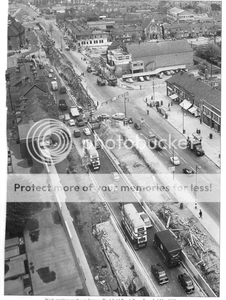
They weren't safe. I don't remember them but my Mother did tell me about a lad from our road who was killed in Perry Barr. He waited for the bus to pass and dashed across the road to be run over by the trailer
 
The tram lines had a lot to answer for, how many cyclists got their front wheels stuck in them. But on a dark foggy night, or even day when the fog was at its worst, how many of us followed them to get us home when the bus's wern't running.
 
nice pic phil...now where on that route was it taken ..looks like a pub on the left but it rings no bells with me and i dont think its birchfield road...

lyn
Hi Lyn, I thought it was Birchfield Road by Chain Walk. The road was narrow there and the tram track went to single line as shown on the map below. Also, what I think is the pub is shown on the map although marked as a hotel. I could however be wrong and maybe other members can comment.

Screenshot (48).jpg
 
Last edited:
The tram lines had a lot to answer for, how many cyclists got their front wheels stuck in them. But on a dark foggy night, or even day when the fog was at its worst, how many of us followed them to get us home when the bus's wern't running.
I can remember having some scary moments with tram lines when I cycled in Birchfield Rd. With regard to the fog in those days, it was so thick and smoky (smog) bus drivers could not see the kerbs. One foggy night going home from Handsworth Tech, I managed to catch a No 5 tram from Villa Cross to Six Ways but then had to walk from there to Great Barr because no buses were running.
 
I remember walking home one Christmas with my parents from my aunt's in Victoria Road to Kingstanding because of the smog, dad said "we'll follow the tram lines" then after a while said "damn that's the Chain Walk." We'd completely missed the Six Ways turn towards Perry Bar.
 
hi eric any ideas why it was called chain walk...i have an idea but just wondered if anyone knew for certain

lyn
 
A cropped view of the pic dated 1954 in post#438 which I think is on Birchfield Rd. There appears to be a pub like building on the corner of Johnstone Rd and it is marked as a hotel on the map in post#442. I have highlighted two features on the building.
Pic1
1_BirchfieldRd1954.jpg

A view of Birchfield Rd dated 1962, and a building in the pic appears to have the same two features. A problem with this pic is that the building now has an upper floor compared to the 1954 pic.

Pic2
2_Birchfield_Rd-1.jpg
Another view dated 1966 shows what looks like the same building and one feature looks the same. Unfortunately a bus blocks nearly all of the front of the building.
Pic3
3_BirchfieldRd1966.jpg
If the building on the corner was a pub I cannot find a name for it or any other information.
 
Last edited:
Lyn
Hava elooked at maps and searched newspapers, but cannot find reference to Chain Walk until it was a street. It must have been before 1865
 
It is Chain Walk which runs from Lozells Rd to Birchfield Rd, part of it can be seen in the map in #442, but does anyone know information about the pub/hotel/premises on the corner of Johnstone St ?
 
It is Chain Walk which runs from Lozells Rd to Birchfield Rd, part of it can be seen in the map in #442, but does anyone know information about the pub/hotel/premises on the corner of Johnstone St ?

p.p1 {margin: 0.0px 0.0px 0.0px 0.0px; font: 12.0px 'Helvetica Neue'; -webkit-text-stroke: #000000} span.s1 {font-kerning: none}

Can’t see any pub mentioned, but a place called The Poplars, Johnstone St, Birchfield is mentioned a few times in sad circumstances. There are also adverts for Metals wanted by Hicks.
 
Thanks Mike, I did much travelling along Birchfield Rd in the 1950s and early 1960s and must have seen it. It is interesting how they added an upper floor sometime after 1954 and then it was all later demolished for the road widening.
 
A 1950 view of Birchfield Road by New Inn Road. I remember that building on the corner of Heathfield Road and the garage with the AA sign on the right. Trinity Road Church is the only building in the photo which is still there today. It's steeple can be seen above the tram.Imagef2.jpg
 
A tram from the trams thread in an unusually quiet Birchfield Rd Perry Barr in the late 1940's.
Tram No 367 in Birchfield Rd and it appears to be full of men and a happy looking group hanging off the back platform.
index.php

(image only visible if logged in)
 
Last edited:
Nice pic of Birchfield Road from its junction with New Inns Road, Mohawk. I also remember that half-timbered building on the corner of Heathfield Rd, but don't know what it was. On the opposite corner of Birchfield and Heathfield is a sheltered accommodation where my parents lived out their last years. We occasionally attended 'parish garden parties' in the (very nice) grounds of Trinity Vicarage. Seeing what that area is today, I could cry....

G
 
cracking shot of birchfield road..looking towards aston lane..can make out the old crown and cushion on the left..the birchfield cinema on the right and the library next to it..the church you can see in aston lane is still there and so are the houses to the left of it but the houses to the right of the church have now gone..

img064.jpg
 
The white building on the corner of Aston Lane would have been the Municipal Bank where sometimes I was trusted by my Mom to take the cash and pay the mortgage. 10/6 a week, how things have changed ! The photo must have been taken from the top of one of the new tower blocks
 
There was once a yard at the back of the old Wilkin's Chemist so I'm wondering if better access by vehicles was needed to that yard for some reason. There's now a building over the yard and the bricked up arch joins the shop with this building. Not sure what this tells us! But it might be worth knowing the types of businesses (before Wilkins Chemists) occupying the shops, along that part of the terrace if anyone has any info. Viv.

The yard at the back of Wilkins Chemist was a warehouse for the chemist shops all over Birmingham owned by Mr A D Norton. There were 39 branches to be stocked from here and above the retail shop. An old carpenter named Mr. Medlam also had a workshop in this yard so there was a lot of traffic up and down in the 50s and 60sMr. Norton's chauffeur used to drive the Bentley up Crown Avenue, what a feat that was as there was a stone half pillar on each side. Mr. Lockley was very careful and never marked it. The old man used to arrive in a star boater and blazer with a fag in his mouth and ash dropping off all over the warehouse floor. Wonder it never all went up in flames. It was taken over by R Weston Chemists from Sheffield.
 
good mornin viv
hope you are well; do you know what year this picture was taken like the rest of our guys i have not seen this before
i presume it as to be before the 1950 era loking in the thirty or fortys i would say
i would dearly love to know the years as i do have abit of intrest in this pub of its early years especialy during the fortys [ early fort years ]
have a nice day viv ; best wishes alan ; astonian;;

Does anyone remember the shop just before the railway bridge, opposite Dodds ironmongers where it supplied hot Vimto in thick glasses with a straw. ver so dingy inside ?
 
I have just spent a couple of hours re-reading this post, another bit of the city lost for ever. I went to Canterbury Road School, danced at Enid Goodwins' lived in Stoneleigh Road when we got married and shopped in Brichfield Road. So many very happy memories.
Regards to the land in Wellhead Lane, my father used to talk about Villa playing there, it was their first ground. The land in Witton Lane was called Aston Lower Ground and used for entertainment, but I'm sure you all know
that. :rolleyes:

Fabulous memories of Enid Goodwins Dancing School, always seemed to be doing the quick step to Joe Loss and "In the Mood". Names remember are Albert Cotterill and his Brother Bill, Alan Redfern, Derek Stockley, Christine Smith. Is it still in existence or gone for ever like all my memories of good old Perry Barr and Aston.
 
The white building on the corner of Aston Lane would have been the Municipal Bank where sometimes I was trusted by my Mom to take the cash and pay the mortgage. 10/6 a week, how things have changed ! The photo must have been taken from the top of one of the new tower blocks

I am a little adrift here as I seem to remember a Clarks shoe shop one side of Aston Lane and a Barclays Bank on the other corner, Cross the traffic lights up towards the Birchfield Picture House and you come to the Birmingham Municipal Bank with its little black saving boxes, next to theBritish Restaurant that did super suet steak and kidney puddings with chips and gravy.
 
hi walsallie as said earlier the white building on the corner of aston lane is indeed barclays and has been for many years..dont know though if it used to be the municipal bank..

lyn
 
A cropped view of the pic dated 1954 in post#438 which I think is on Birchfield Rd. There appears to be a pub like building on the corner of Johnstone Rd and it is marked as a hotel on the map in post#442. I have highlighted two features on the building.
Pic1
View attachment 109753
A view of Birchfield Rd dated 1962, and a building in the pic appears to have the same two features. A problem with this pic is that the building now has an upper floor compared to the 1954 pic.
Pic2
View attachment 109754
Another view dated 1966 shows what looks like the same building and one feature looks the same. Unfortunately a bus blocks nearly all of the front of the building.
Pic3
View attachment 109755
If the building on the corner was a pub I cannot find a name for it or any other information.
 
Back
Top