Thanks Lyn. That's good of you. Maybe one for a winter visit! Viv.
-
Welcome to this forum . We are a worldwide group with a common interest in Birmingham and its history. While here, please follow a few simple rules. We ask that you respect other members, thank those who have helped you and please keep your contributions on-topic with the thread.
We do hope you enjoy your visit. BHF Admin Team -
HI folks the server that hosts the site completely died including the Hdd's and backups.
Luckily i create an offsite backup once a week! this has now been restored so we have lost a few days posts.
im still fixing things at the moment so bear with me and im still working on all images 90% are fine the others im working on now
we are now using a backup solution
You are using an out of date browser. It may not display this or other websites correctly.
You should upgrade or use an alternative browser.
You should upgrade or use an alternative browser.
Birchfield Road Perry Barr
- Thread starter debi
- Start date


oldMohawk
gone but not forgotten
Hi Lyn, I'm afraid I don't know the date but looking at the clothes worn in the photo I would say around 1920.cracking photo of trinity church OM i was christened there...any idea of the year
lyn
Phil
thanks phil...
viv forgot to post this with the photo i posted..not sure if its been on before but here is the link to the report re roman kiln it contains some great maps as well..i got it all printed off makes interesting reading
https://archaeologydataservice.ac.u...502-1/dissemination/pdf/birmingh2-28474_1.pdf
Thanks Lyn. Interesting report. The kiln might not be something we'd recognise as a kiln even if there's any of it left. It might just look like rubble.
I've often wondered if additional sites around Perry Barr Village/Perry Village go that far back too given the rivulets, rivers and streams and its many mills scattered about. Some of the mills have a long history and perhaps these were sites of early furnaces ? All a bit speculative, but I imagine there's more than we think given the proximity to the Icknield Way.
The area was largely agricultural up until 80 years ago and I'd have loved to have had a poke around before all the estates were built. Viv.
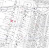
just a final map showing where no 224 wellington road was (mentioned in the excavation report) also showing the spot where the roman kiln was found..looking at this map it looks as though no 224 is down a gully but if you look at the map on post 404 is shows that it either had a very long garden or it was a wooded area
Attachments
oldMohawk
gone but not forgotten
In my childhood and youth I must have gone along Birchfield Road at least 3 or 4 times a week. When I bought my first car I often sat in traffic jams there just like in this photo which is from the Library of Birmingham's collection.
Their information with the photo is
I cannot place where this is on Birchfield Road ... I can see the pub sign but the other side of the road does not look like it should do opposite the pub ... Brooks Opticians and a little shop named Cabin ... anyone got any ideas ?

Their information with the photo is
Date:1958
Description:Birchfield Road, Perry Barr, looking south before the construction of the Birchfield Road Underpass in the early 1960s. At the top right-hand corner is the inn sign outside the Old Crown & Cushion.
I cannot place where this is on Birchfield Road ... I can see the pub sign but the other side of the road does not look like it should do opposite the pub ... Brooks Opticians and a little shop named Cabin ... anyone got any ideas ?
oldMohawk
gone but not forgotten
Me again ... pondering about my photo in post#418. I don't think it is Birchfield Road, I think it is Wellington Road and the two photos below appear to confirm this.
The photo from post#418. Note the litter bin on the pavement, a bus stop further along, the Atkinsons Pub sign, and the building beyond it with a light colour on its lower wall and darker above.

I think the above photo has been taken from an upper floor window of the modern Crown and Cushion Pub (just visible in the photo below) looking down on Wellington Road.
A photo of Toys Chemist which was on the corner of Birchfield Road and Wellington Road. Note on the other side of the road is a litter bin, a bus stop, a pub sign and a building with a light and dark coloured wall.

The photo from post#418. Note the litter bin on the pavement, a bus stop further along, the Atkinsons Pub sign, and the building beyond it with a light colour on its lower wall and darker above.
I think the above photo has been taken from an upper floor window of the modern Crown and Cushion Pub (just visible in the photo below) looking down on Wellington Road.
A photo of Toys Chemist which was on the corner of Birchfield Road and Wellington Road. Note on the other side of the road is a litter bin, a bus stop, a pub sign and a building with a light and dark coloured wall.
Last edited:
oldMohawk
gone but not forgotten
A view of Birchfield Road looking north and a road roller turning into Aldridge Road is holding up some buses. On the right next to Wilkins Chemist is Crown Avenue ... which I first learnt about earlier in the thread ... I never even noticed it in the 1950s when I walked past.

Guys, I think you may well be correct about that first photo being Wellington Road....I did say my memory is very vague. I do remember Toy's Chemist - in fact, I was going to ask what was on the corner of Birchfield Rd and Wellington Rd before the 'new'(?) C&C was built, but you've answered it for me.
I definitely remember having an eye-test at Brooks Opticians, and I do remember, slightly more vaguely, walking past the opticians and the car-lot with my Mom as we made our way to the station.
However, thinking about it, I would guess that Mom, who was a very, very cautious person, may well have crossed Birchfield Rd on the library side of the crossroads with Wellington Rd, then walked down Wellington Rd a short distance to where it was easier to cross. This was all nearly 65 years ago, don't forget. What I would say, though, is that the small pub on Birchfield Rd opposite today's C&C (for want of a better description) was definitely called The C&C at one time - my dad used it on Saturday lunch-times in the 1970's and I sometimes went to collect him and have a quick 'un myself. There again, memory does tend to play tricks with one....
Great thread, though. I love seeing old pics of 'my' area when I was a nipper - a good old working-class neighbourhood that was ripped apart.
G
Posts discussing the various C&C pubs have been moved to an earlier thread called "Crown and Cushion pubs Perry Barr"https://birminghamhistory.co.uk/for...d-cushion-perry-barr.25060/page-4#post-574274
Viv.
Viv.

oldMohawk
gone but not forgotten
At the terminus on Birchfield Rd the trams stood in the middle of the road with traffic passing both sides. Some interesting things in this pic ... a Vee shaped object on the wire above the tram, a 'two tone' Bundy Clock, and what look like flags hanging on the pub. The tram conductress appears to be having a chat to the right of the clock and two women sitting on the tram's front balcony seat. Maybe a tram expert will know what the Vee shaped object is.

Di.Poppitt
GONE BUT NOT FORGOTTEN
Phil the land in Normandy road where the cricket match was being played is, on the later map, interestingly still green. How has that happened when so much land of inner cities has been used for housing?
The traffic jam on Birchfield Road shows only one half of the picture. We lived in Stoneleigh Road, which runs parallel to Birchfield Road, as I walked home from work at ICI I walked past a line of cars usually at a stand still. I regularly had a chat to my husbands cousin who sat in his 'Bubble' car on his way home to Sutton.
The traffic jam on Birchfield Road shows only one half of the picture. We lived in Stoneleigh Road, which runs parallel to Birchfield Road, as I walked home from work at ICI I walked past a line of cars usually at a stand still. I regularly had a chat to my husbands cousin who sat in his 'Bubble' car on his way home to Sutton.
oldMohawk
gone but not forgotten
This photo is in the 'A few Trams for a Change' thread and shows two trams queuing to get to the terminus. The library can be seen and the Birchfield cinema and if we could see what film was on we could have dated the photo but it looks to be just after the end of WW2. I can see at least five buses in the view which gives some idea of the traffic jams in those far off days. (linked image only visible if logged in)

Last edited:
Ray Griffiths
master brummie
The angle piece over the wire is to hide the sparking when they run the current pickup pole round and engage with the power line, if you look it is inline with windows in pub.At the terminus on Birchfield Rd the trams stood in the middle of the road with traffic passing both sides. Some interesting things in this pic ... a Vee shaped object on the wire above the tram, a 'two tone' Bundy Clock, and what look like flags hanging on the pub. The tram conductress appears to be having a chat to the right of the clock and two women sitting on the tram's front balcony seat. Maybe a tram expert will know what the Vee shaped object is.
View attachment 109663
The clue is the bundy clock the tram would be stopped at that point following it's journey from city it should have pulled up a bit further to locate . It was possibly installed during the war to prevent aircraft seeing the flash when changing direction at night
oldMohawk
gone but not forgotten
Thanks Ray, the tram is standing at the terminus and I remember the conductors/conductresses had to pull the collector pole down and walk round in traffic to get it back on the wire and I thought it might have been some sort of guidance system to save them having to fiddle with it at the same time as watching out for cars and bikes etc. I don't think it remained there long because I have never seen it in other pics.
oldmohawk ...")
oldmohawk ...
Simon4130
master brummie
Photo in #430 is very definitely taken during WW2 or very soon after it ended as confirmed by the V canopy over the wiring, white bumper on the tram and the white painted base of the Bundy clock.
I would agree the photo in #433 is soon after the war ended as the BCT buses have the darker roofs introduced during the war but nothing seems to have blackout headlamps still fitted.
Two great photos.
Simon
I would agree the photo in #433 is soon after the war ended as the BCT buses have the darker roofs introduced during the war but nothing seems to have blackout headlamps still fitted.
Two great photos.
Simon
Map attached shows 296 in red
Thank you Mike much appreciated...