I’ve found these two; one at Snow Hill, the other at the Old Bill and Bull pub (formerly the Hay Mills Police Station). Photos from the Geograph site. Are there others in the area ? And presumably they’re marked on OS maps. Viv


 www.thenbs.com
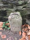
The symbol of the crown indicates crown property, some benchmarks can be quite ornate mostly of cast iron , also find them ( if the levels allow) on stone mile markers on roads , the old GPO stone utility markers.This one is outside St Mary’s Church in Ward End. It seems to be more detailed than that in post #1. What would the purpose be of the other markings ? Viv.View attachment 174605
I couldn't find it. However, I am not sure whether it was supposed to be on the house wall (maybe covered by modern extension) or the garden wall.I will have to investigate tomorrow as there is one marked at the end of our road.
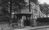
St. Mary's Warwick Rd Acock's Green.This one is outside St Mary’s Church in Ward End. It seems to be more detailed than that in post #1. What would the purpose be of the other markings ? Viv.View attachment 174605
 www.ordnancesurvey.co.uk
I don’t think it is a benchmark. I am sure one of the ex-GPO people will possibly correct me, but I understand this is a GPO underground cable or joint or junction marker. They were quite common in Birmingham, but I assume are not longer used. The arrow is a government mark od ownership.A long way from Brum, Dulverton, Exmoor. A GPO Bench Mark?
The broad arrow or Pheon commonly known as a 'Crows Foot' was used extensively to identify Government property, the most earliest and common use for the broad arrow was on the prisoners in jails or transported to Australia .I don’t think it is a benchmark. I am sure one of the ex-GPO people will possibly correct me, but I understand this is a GPO underground cable or joint or junction marker. They were quite common in Birmingham, but I assume are not longer used. The arrow is a government mark od ownership.
Yes, the broad arrow shows it it government property, the original broad arrow symbol came from the British military to indicate their ownership of an asset . Where the Bench Mark / Datum has the horizontal bar as a datum point for setting out , surveying, etc.Is that also the case for the one in post #9, it looks similar to the one in post #15 ? Viv.