-
Welcome to this forum . We are a worldwide group with a common interest in Birmingham and its history. While here, please follow a few simple rules. We ask that you respect other members, thank those who have helped you and please keep your contributions on-topic with the thread.
We do hope you enjoy your visit. BHF Admin Team -
HI folks the server that hosts the site completely died including the Hdd's and backups.
Luckily i create an offsite backup once a week! this has now been restored so we have lost a few days posts.
im still fixing things at the moment so bear with me and im still working on all images 90% are fine the others im working on now
we are now using a backup solution
You are using an out of date browser. It may not display this or other websites correctly.
You should upgrade or use an alternative browser.
You should upgrade or use an alternative browser.
Beggars Bush
- Thread starter Phil
- Start date
Radiorails
master brummie
Some guidance here:The corn maps were one of the tithe maps drawn to make clear what tithes were extant, so it could all be regularised.. I am not sure what the exact difference between the corn and tithe maps were.
https://www.nationalarchives.gov.uk/help-with-your-research/research-guides/tithes/
Pedro. Penns Lane is an ancient lane known to have existed in 1596 and was the lane leading from Penns Mill towards Erdington.
Looking at a 1913 map the footprint of the middle older shops/buildings on B'ham Road near the top of Penns Lane seem very different to the adjoining shops. Two very simple buildings. I suspect these are older than the adjoining buildings.
Also shown is Broadfields which is set right back off Birmingham Road.

Then looking again at the 1834 map the buildings look to be set very close to the main road. So I'm not sure it can be Broadfields on the 1834 map. Looking closely at the 1834 map you can just make out a lane between those buildings. I think this must be the position of the later Florence Road. I'm still wondering if this was once a farm or even an inn? Being positioned like that so close to the ancient Penns Lane just raises (even more!) questions for me.
And finally, assuming there was a Beggars Bush here, I would expect it to be near the boundary eg near the Old Bell and Cuckoo perhaps ? .

Looking at a 1913 map the footprint of the middle older shops/buildings on B'ham Road near the top of Penns Lane seem very different to the adjoining shops. Two very simple buildings. I suspect these are older than the adjoining buildings.
Also shown is Broadfields which is set right back off Birmingham Road.
Then looking again at the 1834 map the buildings look to be set very close to the main road. So I'm not sure it can be Broadfields on the 1834 map. Looking closely at the 1834 map you can just make out a lane between those buildings. I think this must be the position of the later Florence Road. I'm still wondering if this was once a farm or even an inn? Being positioned like that so close to the ancient Penns Lane just raises (even more!) questions for me.
And finally, assuming there was a Beggars Bush here, I would expect it to be near the boundary eg near the Old Bell and Cuckoo perhaps ? .
Lady Penelope
master brummie
Thanks Everyone, a lot of information to take in. Much of the land around the Green Lanes area (and indeed Sutton town itself) was owned by Emmanuel College, Cambridge. I shall take some time to work out where these plots were and have a look at the tithe information.
Lady Penelope
master brummie
Viv, sorry I missed your post when I read the above but you can see where the boundary is - it runs along the side of Broadfields on the 1913 map, shown by the dotted line. Such a lot to think about again.
Lady Penelope
master brummie
I have just been looking at the 1851 census for this part of the road. I could find nothing to say that there was an inn, beerhouse or anything between Broadfields House and the Horse & Jockey, so it looks as if it had gone by then. I find the 1841 census quite difficult round that area as everything seems to have a different name and the enumerator seems to jump around although this may be that there is a great distance between dwellings.
The old properties I mentioned in an earlier post looked to be early Victorian and they would be the four opposite Holifast Road (with the white frontages on the map). They were to the right of the ones in Viv's modern street view so if the Beggars' Bush was opposite Penns Lane it would be where Oxfam is now.
The old properties I mentioned in an earlier post looked to be early Victorian and they would be the four opposite Holifast Road (with the white frontages on the map). They were to the right of the ones in Viv's modern street view so if the Beggars' Bush was opposite Penns Lane it would be where Oxfam is now.
Lady Penelope
master brummie
Not on the 1841 census either. Once I'd worked out which way the enumerator was going.
Lady Penelope
master brummie
This is a response to my last post. Believe it or not, although I have been looking at censuses since Hector was a pup, I have only just found out that at the beginning of the census the enumerator will usually tell you exactly where he went on his perambulations. I have spent X amount of years looking for landmarks etc. so that I can be sure I'm actually in the right place. Just goes to show that you're never too old to learn!
Lady Penelope
master brummie
Yes Mike, you're right. The 1911 is completely different as householders filled in their own returns didn't they? With, I have to say, quite varying results. It would be interesting to find out how the forms were distributed and collected. I meant to mention that it was missing from this census so thanks for pointing it out. May have confused people otherwise.
Radiorails
master brummie
..........and worth remembering that many people could not read or write. So presumably other people helped fill in their forms - with varying degrees of accuracy I am sure.
Keith Berry photographed the Princess Alice Orphanage site which was the other side of Jockey Road from the Beggars Bush pub. His photos and comments below. Click the pic to enlarge
View attachment 114244
Hi OM,
very interested to see the photos of the Princess Alice, and also reference to car boot sales. I have (very) vague memories of going to the Orphanage when very young, taken there by my mother at Christmas, but I'm blowed if I can remember why. Regarding car boot sales, my wife and I did several there, and always made a bob or two! The tower was quite a landmark in the area. Then about 15 years ago I used to rehearse at the older building at the back of the Pizza Hut, this building I think being a remaining part of the Orphanage - it basically consisted of a large hall with a good stage, and kitchen facilities. I don't even know if it's still there. But I do recall that we had the hall after a kids' karate class, and a few of the youngsters would stay behind for a while to listen to music they'd probably never heard before - Dylan, Fairport, blues, stuff like that.
G
Lady Penelope
master brummie
Brampton Hall has only just gone. Our cubs used to play football on the pitches there. I think they call it progress.

Lady Penelope
master brummie
I wonder where that was Pedrocut?
Lady Penelope
master brummie
Going back to the Beggars Bush at Green Lanes - I've been reading about the parish boundary dividing Sutton from Erdington and apparently Penns Lane, a very ancient road, was the boundary originally rather than Holifast Road as at present. This would make sense for the parish boundary theory of 'Beggars Bushes'.
I believe the New Oscott Bush was originally The Hawthorn Bush and on maps from the early 1800's the field to the west of the Chester Road is Hawthorn Brook Field leading down to Shortheath Road, the 'bogs' and Witton Lakes.
I believe the New Oscott Bush was originally The Hawthorn Bush and on maps from the early 1800's the field to the west of the Chester Road is Hawthorn Brook Field leading down to Shortheath Road, the 'bogs' and Witton Lakes.
Another view to add to this thread. Sorry no date. Viv.

Lady Penelope
master brummie
Sorry - will repost.
Lady Penelope
master brummie
Pedrocut, your post 21 mentions 'a' Beggar's Bush but it's not the one at New Oscott. I remember seeing this name on an early hand-drawn map and it appeared to the right of what is now Birmingham Road, Wylde Green. This was the Holly Fast Common, now Holifast Road and
I found this picture some time ago and then when I came to post it I couldn't find the thread. Viv pointed me in the right direction and then I lost the picture...... sign of the times maybe? However, I now have both thread and picture. This was taken from a book in Sutton Library and shows what I believe was the site of the 'original' Beggars Bush at the junction of Penns Lane and Birmingham Road. (This picture may be better on another thread, if so please feel free to move it - thanks).

Hello Lady Penelope,I found this picture some time ago and then when I came to post it I couldn't find the thread. Viv pointed me in the right direction and then I lost the picture...... sign of the times maybe? However, I now have both thread and picture. This was taken from a book in Sutton Library and shows what I believe was the site of the 'original' Beggars Bush at the junction of Penns Lane and Birmingham Road. (This picture may be better on another thread, if so please feel free to move it - thanks).
View attachment 147327
Could you provide any evidence for thinking the original Beggars Bush was located at the Penns Lane/Birmingham Road Junction please? such as: -
which book in Sutton Library?
what time frame would this be?
I have researched the Beggars Bush back to 1830 and it stood at New Oscott until that time so Id appreciate any information you could offer.
thank you
Keith Berry photographed the Princess Alice Orphanage site which was the other side of Jockey Road from the Beggars Bush pub. His photos and comments below. Click the pic to enlarge
View attachment 114244
I have a very vague childhood memory of the orphanage buildings. Does anyone know when they were demolished? I seem to recall late 80s/early 90s? Is there a thread about the place?
oldMohawk
gone but not forgotten
There is some information about the Orphanage in the website below ..I have a very vague childhood memory of the orphanage buildings. Does anyone know when they were demolished? I seem to recall late 80s/early 90s? Is there a thread about the place?
")
Princess Alice Orphanage, Sutton Coldfield, Warwickshire
Lady Penelope
master brummie
Hello Lady Penelope,
Could you provide any evidence for thinking the original Beggars Bush was located at the Penns Lane/Birmingham Road Junction please? such as: -
which book in Sutton Library?
what time frame would this be?
I have researched the Beggars Bush back to 1830 and it stood at New Oscott until that time so Id appreciate any information you could offer.
thank you
Hello Rossbret,
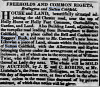
I first saw the name Beggars Bush on a map from about 1804 which I had from Sutton Library and will try to locate this later. However, here are a few of the mentions of the 'other' Beggars Bush. The first map is from Midland Pubs, and the other information is from this site on another thread. Hope these help.
The first mention I have of the New Oscott Bush was on the 1840 census. Very interesting that you've managed to pre-date this. Always something new to learn!
The Mr Cottrell mentioned in the newspaper article lived at Broadfields House which stood where the parade of shops is opposite to the Co-op at Wylde Green.
I will try to find the original discussion on the above and let you know.
Attachments
Lady Penelope
master brummie
Second Post for Rossbret,
The photo I posted which you queried was from a book of photographs from Sutton Library and relates only to the older buildings shown not to the pub in question (First Beggars Bush).
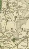
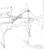
There's quite a discussion earlier on this thread concerning the 'other' Bush. Here's another couple of maps with this pub marked which I think appeared on this thread. Also the map I referred to in my earlier post from the very early 1800's (believed to be that date due to the direction of one of the roads not shown on this sketch/map - it's part of a larger one photocopied from Sutton Library and was drawn to show the land holdings in the area.)
The photo I posted which you queried was from a book of photographs from Sutton Library and relates only to the older buildings shown not to the pub in question (First Beggars Bush).
There's quite a discussion earlier on this thread concerning the 'other' Bush. Here's another couple of maps with this pub marked which I think appeared on this thread. Also the map I referred to in my earlier post from the very early 1800's (believed to be that date due to the direction of one of the roads not shown on this sketch/map - it's part of a larger one photocopied from Sutton Library and was drawn to show the land holdings in the area.)
Attachments
Lady Penelope
master brummie
This is a PS to the last post - if you enlarge the 'Beggars Bush' area you can definitely see what appears to be a bush a 'bush' in the middle of the road, complete with shadow. Or am I seeing things? Also, to clarify, the dark line is actually the boundary between Erdington and Sutton not a road. I may have confused things earlier on this thread.
Ray chancellor
proper brummie kid
Beggars bush suttonI don't think this will fool anybody for long, but it's only a bit of fun to get the old grey matter active.
Phil