• Welcome to this forum . We are a worldwide group with a common interest in Birmingham and its history. While here, please follow a few simple rules. We ask that you respect other members, thank those who have helped you and please keep your contributions on-topic with the thread.

    We do hope you enjoy your visit. BHF Admin Team
  • HI folks the server that hosts the site completely died including the Hdd's and backups.
    Luckily i create an offsite backup once a week! this has now been restored so we have lost a few days posts.
    im still fixing things at the moment so bear with me and im still working on all images 90% are fine the others im working on now
    we are now using a backup solution

Beggars Bush

The story of the pauper burial under the bush seems very unlikely…

Beggar’s Bush…Brewer’s Phrase and Fable (1870)…

Beggar’s Bush is the name of a tree which once stood on the left hand side of the London Road from Huntingdon to Caxton: so called because it was a noted rendezvous for beggars.
 
IMG_1718.jpg IMG_1720.jpg
The Beggars' Bush (the Inn)...what's in a name!

Having delved into the history of the name of the Beggars' Bush, there are a few facts that may be of interest, and no doubt will add to the confusion!

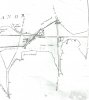
I believe that just prior to the proposed Inclosure of the commons and waste lands in 1827 all that existed was a bush that was locally known as the Beggars' Bush. It stood at the junction of the Old Chester Road and the road from Kingstanding, at the county boundaries of Warwicks and Staffs. The area was known as Coldfield Common. It was proposed to have the 40ft Road No.4 to run from the Beggars' Bush eastwards over the common to reach the Horse and Jockey public house. (Jockey Road.)

Looking at the 1834 map a few years later Jockey Road can be seen, but no buildings appear around the junction. I would guess that at this point there was not an Inn built.

The consensus is that a chap called William Goodwin was the first landlord of a Pub that stood at the junction in 1841. In the census of 1841 there is a William Goodwin listed as being 35 years old and Publican in Coldfield, and this backs up the idea that there was an establishment of some sort there. Also in Pigot's Dir of 1841 he is down as in Sutton Coldfield as a retailer of beer, but in the list of pubs the Horse and Jockey is mentioned but nothing of a Beggars or Hawthorn Bush, or even Bush.

The 1851 census lists him as being 46, and living at 33 Old Chester Road and a beer seller. This may suggest that the establishment was still not a fully-fledged public House.

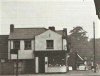
In 1861 it is said that he took out a new lease and built a new pub adjacent in Jockey Lane, along with five cottages, and converted the old pub building into three cottages. This may be substantiated by the 1861 census that tells that he is 55 years old and a Licenced Victuller living at the HAWTHORN BUSH, Old Chester Road.

The name Hawthorn Bush is backed up by entries in Morris Com Directory of 1866, and PO Directory for 1868.

In the 1871 census William is 66 and down as Publican at 246, Jockey Road, New Oscott. But also in September 1871 there is a notice of a clearance sale at the Beggars' Bush Inn by the executors of the late William Goodwin. As we have seen the Beggars' Bush was again sold by a Mr King in 1874.

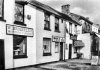
Coming up to the time of the picture at the start of the Thread there is a George Harding in charge, and in the 1901 census George Harding is 63 and at the BUSH INN, New Oscott. In the 1903 Kelly's Dir he is down as of the BUSH INN, Chester Road. More confusion in the 1904 Kelly's where he is down as Beggars' Bush, New Oscott, but in the Commercial section as the Bush Inn! George may have moved on to the Four Oaks PH by 1912.

It is strange that the first mention of the Beggars' Bush, or any mention of a PH in the location is in 1858 when there is a suicide described as being near the new college on the road to the Beggars' Bush PH. As far as I can see every other mention is of the name Beggars' Bush through until at least 1939. Maybe William Goodwin successfully built up his business from 1841, and at the time of his rebuild in 1860 he decided not to have a Beggar connected to it and called it the Hawthorn Bush. George Harding may have been of the same mind and called it the Bush, but all the locals and the Press always thought of it as the Beggars!
 
This extract from Sutton Coldfield.net site supports your research that there was a bush pre-1841, as a boundary marker. But nothing else, and no inn. And that some sort of building/house/pub appeared 1841. Goodwin was living there with his family but he built a new pub and converted the old one into cottages. This is confusing. But I too suspect the 1841 pub was probably just a house offering refreshment (beer etc). Goodwin probably realised it was a good place to build his own purpose-built pub. After all it would have been a good location with coaches passing along those roads. Or am I in the land of the fairies here?!

Now wondering if we know enough about the two pubs and the bush to pinpoint where each was exactly in relation to the roads. Viv.

image.jpeg
 
Pedrocut and Vivienne
Many thanks for some very interesting history. I lived there 21 years, drank there a few times and never knew any of this, however the only time I tried to find out why it was called the Beggars Bush, I was told that there had been a bush there and a beggar who slept under the bush and one morning was found dead. For someone who at that time was more interested in ale and the opposite sex it seemed reasonable enough and I asked no more.
Bob
 
Pedrocut, your post 21 mentions 'a' Beggar's Bush but it's not the one at New Oscott. I remember seeing this name on an early hand-drawn map and it appeared to the right of what is now Birmingham Road, Wylde Green. This was the Holly Fast Common, now Holifast Road and
 
sorry, posted before I'd finished!
The Bell and Cuckoo is mentioned on the Erdington thread and although I do remember the name 'Cotterell' I can't remember which house this refers to. Just on the opposite side of the Chester Road to the one in Pt 1 of this post. Hope this makes sense.
 
Here is a map (not very clear from The story of Sutton Coldfield by Roger Lea), showing (presumably with no additions) Beggars Bush ( as a place) marked on the map of the Corn survey of 1824-25

beggars bush corn maps0001.jpg
 
interesting map mike...now what on earth was jordons grave:D for another time maybe..
 
IMG_1725.jpg IMG_1726.jpg

The Beggar's Bush and the Hawthorn Tree...

Going back to the Midlands Pub site it shows a map from 1821 where the Beggars' Bush (place) is position somewhere near the present Yenton Pub.

https://www.midlandspubs.co.uk/birmingham/erdington/beggars-bush.htm

It would then suggest that the Beggars' Bush (place) was not as shown on the 1834 and 1880ish maps. The present Beggars' Bush Pub is at the site of the Hawthorn Tree!

In his book "History of the Forest and Chase of Sutton Coldfield" L Braken, writing in 1860, and describing the Sutton Parish Boundary says...

"The Coldfield formed an extensive waste, united to heaths of other parishes. Upon it lay a lake or mere. It has some spots as Welshman's Hill, Jordan's Grave, where tradition fails: but King's Standing is a small artificial mound, reputed to be the position occupied by Charles...."

"......In the early part of this century (1800s) a Hawthorn tree in the middle of the turnpike road marked the division between this parish and Erdington, and the Beggar's Bush, on the Coldfield, was a similar landmark."
 
Here's the map I mentioned in Post #25. It's obviously just a sketch and not to scale but interesting all the same. Although it's difficult to read, Beggars Bush is about where Green Lanes comes onto Birmingham Road. Perhaps it's a general thing and travellers met at junctions of busy road by a 'bush'.
Lyn, I'm sure I read that Jordan was murdered and buried on the boundary of the parish but not sure who he actually was.
 

Attachments

  • Mag0003.jpg
    Mag0003.jpg
    299.9 KB · Views: 20
Going back to the Staffs/Warks boundary query. I read yesterday that the bush marked the boundary between 'Erdington and Perry'. Many years ago Perry Barr was part of Handsworth which was then in Staffordshire.
 
Pedrocut, I'm really puzzled by this information from Midlands Pubs. I think we'll find that there were many such places in years gone by. Just another one to add to my list of 'must find outs'. I also spotted a Dance Hall (?) on the map - that's certainly something to think about!
 
Last edited:
Pedrocut, I've had time to look at the map now and the Beggars Bush in 1823 is actually facing Penns Lane, not as my map (which is not to scale) suggested, further up towards Wylde Green Road. The road just a little further up from the BB is Little Green Lanes and Green Lanes itself continues to the main road. My map is definitely pre-1801 as Goosemoore Lane is shown and that carried straight on to Chester Road. After that date it turned left and joined Court Lane.

The buildings look to be about where the oldest buildings in this shopping area are. There used to be a very old bookshop where the Irish Bank is now and next to that was an off-licence, also a very old building. This has now been replaced by a bookies. I worked at the top of Penns Lane in the late 1960's and I'm trying to picture these buildings. Perhaps someone has a photo?

As far as the 'dance hall' is concerned, it seems to be opposite the end of Grange Road, not quite in Pype Hayes park - very interesting!

I think the Mr Cotterell referred to in your post #21 lived at Broadfields House. This was a very large property and I've failed to find anything out about it. No pictures exist although I believe it was there until the trams arrived definitely until the parade of shops now there was built, around the turn of the 20th century, together with Broadfields Road.

Just as an aside, I visited Warwick Record Office yesterday and looked at an original enclosure map. It was made of vellum so very stiff and hard to handle. When unrolled it covered 4 large tables pushed together.

I'm now going back to read all the previous posts on this thread as I couldn't take it all in the first time.
 
PS to last post. Shops at the top of Penns Lane and the outdoor on the corner.
 

Attachments

  • Wylde Green Shops.jpg
    Wylde Green Shops.jpg
    16 KB · Views: 27
  • Outdoor.jpg
    Outdoor.jpg
    55.4 KB · Views: 27
Sorry, my post #32 should have said 'Sutton Coldfield and Perry'.
I've gone through all the posts and it looks as though the answer to Viv's original question is that whoever put the caption on the postcard put the Birmingham Road details on the Chester Road pub.
 
Thanks Pedro, Mike and Lady P. Lady P I think your conclusion is right on the caption.

I've just spent this evening trying to map all this out on a modern map so I can get it clear. And my word, it got very complicated ! One thought I've had concerns the distance between the suggested locations for the Beggars Bush (place). If I'm understanding this, the distance is pretty significant ie Chester Road/Jockey Road junction and Birmingham Road/Penns Lane area. I wonder if there's been confusion over time because of the descriptions used (and maybe interchangeable use) eg Beggar's Bush, Beggars' Bush or Bush.

Need to study it a bit more before I get it clear in my head! Viv.
 
Hi Lady P. I think your point about the older 'shops' on Birmingham Road could very well help us. It might tell us a bit more if we can find some history about them. I have a 'gut' feeling they were originally a short row of cottages. And it looks to me that the shops with the curved windows were a later addition of houses/shops. So wonder if the early middle 'cottages' could give us any clues as to what was there before any later Victorian development.

All guesswork as usual - but I do love exploring ! Viv.

image.jpeg
 
According to Bill Dargue's site there were two Beggars Bushes, as we've been exploring. This also seems to back up Lady P's suggestion about the incorrect labelling of the image in post #1. One BB was at Erdington (Penns Lane/B'ham Road) the other was at New Oscott (Jockey Road/Chester Road). Don't know why I missed this info on his site, but it's right at the very bottom of the Beggars Bush page. Here's the quote from Bill's site:

Beggars Bush, Erdington

C & J Greenwood's 1821 map of Warwickshire also shows a Beggars Bush at the junction of Birmingham Road & Penns Lane; this site too is on the parish boundary, here of Erdington & Sutton Coldfield.

So both Beggars Bushes were on parish boundaries. So I'm going to go with the explanation:- they were places of refuge for beggars when being kicked out of one parish - so they'd nip across the boundary to avoid punishment!

Would still like to find out more about those cottages on Birmingham Road though as it might tell us more about that particular Beggars Bush. Viv
 
I'm looking at maps for the 1700's when I next go to the library so I'll keep this all in mind. I never ceased to be amazed at the amount of knowledge, pointers and information members post on this forum.
 
I'm looking at maps for the 1700's when I next go to the library so I'll keep this all in mind. I never ceased to be amazed at the amount of knowledge, pointers and information members post on this forum.

i agree pen..thats why this forum is so good...its a place of learning for all of us:)

lyn
 
Keith Berry photographed the Princess Alice Orphanage site which was the other side of Jockey Road from the Beggars Bush pub. His photos and comments below. Click the pic to enlarge
NewOscott.JPG
 
Mike, although I've heard of corn maps / corn laws before I'm not aware of their purpose. What exactly were they please? Did they show every building?
 
Thanks Mike.

Maybe Mike knows the answer to whether the Corn Maps showed all details Lady P, but the 1834 map seems to show some sort of building(s) at that point. Think it could be a farm perhaps? Viv.

image.jpeg
 
Yes, that's interesting Viv. I think the larger of the buildings is Broadfields House, must try to find out when that was built. Not sure it would be connected with Penns Mill as that is a long way down the hill from Birmingham Road. It's a possibility though as some of my Hileys lived in Little Green Lanes and they worked at the mill prior to it moving to Hay Mills (I think it was). Interesting also is this enlarged map shows Sheffield's farm before the railway destroyed it (just north west from the building in question).
 
sorry, posted before I'd finished!
The Bell and Cuckoo is mentioned on the Erdington thread and although I do remember the name 'Cotterell' I can't remember which house this refers to. Just on the opposite side of the Chester Road to the one in Pt 1 of this post. Hope this makes sense.

There were Cottrills/Cottrells (William) living at Broadfields in 1879 and I think a daughter married an Elkington. Viv.
 
Just to give an idea of the development of the area around Penns Lane.

The Inclosure of 1827 created "a road of width 30 feet, starting at the west end of the road leading from the said green to Newhall Mill, and extending in a westward direction, over the middle of the said green, and terminating at the turnpike road leading from Birmingham to Sutton." I think this would be the present Wylde Green Road, and Penns Lane may have already existed?

A footpath was created in 1847 from near the School in Green Lanes. The school must have existed before that date and is shown on the 1887 map as being on the S side of Green Lanes.
 
Back
Top