• Welcome to this forum . We are a worldwide group with a common interest in Birmingham and its history. While here, please follow a few simple rules. We ask that you respect other members, thank those who have helped you and please keep your contributions on-topic with the thread.

    We do hope you enjoy your visit. BHF Admin Team
  • HI folks the server that hosts the site completely died including the Hdd's and backups.
    Luckily i create an offsite backup once a week! this has now been restored so we have lost a few days posts.
    im still fixing things at the moment so bear with me and im still working on all images 90% are fine the others im working on now
    we are now using a backup solution

ANN STREET CITY CENTRE

Not a very good image, but I think this was the bank built in 1871. The building no longer exists. Viv.

F6899029-A35A-4A32-8D31-35483BC8095A.jpeg
 
Somebody correct me if I’m wrong, but I think this replaced the original Ann Street Lloyd’s Building, and not so long ago.I think Eden Place is to the left, but it doesn’t seem to be marked on maps. Viv.
 

Attachments

  • 5CE9BC6C-2524-4662-8EFE-E781AC7200D5.jpeg
    5CE9BC6C-2524-4662-8EFE-E781AC7200D5.jpeg
    647.7 KB · Views: 11
Viv
What do you mean by not shown on maps? Certainly it does not seem to be named on Google maps, though you can "walk "down it on streetview. Bur maps up to at least 1966 do show it

map c1966 showing eden place.jpg
 
Agreed, Viv, unindexed, you just get a gay bar of the same name in Sherlock Street, although, as Mike says, the name plate is clearly visible and Google need to get their act together. However, if my memory is correct, there used to be a Westminster Bank on that corner where Starbucks is, but although a sandstone colour, I can't remember all those round curves, but I am talking 1950s!

Maurice :cool:
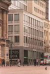
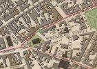
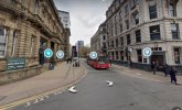
Maurice. Actually Westminster Bank was in the blank space on the map that Mikejee posted on the corner of Colmore Row and Newhall Street. It was then replaced by the NatWest Tower which during the past two years has also been demolished and replaced with another tower block. I have not been in the centre of Birmingham for over a year now so I am not sure of the current status of the new building whether it is finished or not.

2009 & Sept 2020
1618401014996.png1618401046228.png
 
I have managed to find a photo of the 1960s Lloyds Bank Colmore Row but do not yet have a date when this was demolished. You may need to click on the picture to see it properly.
 

Attachments

  • Lloyds Bank Colmore Row 1960s building.png
    Lloyds Bank Colmore Row 1960s building.png
    168.3 KB · Views: 12
I have spoken to my friend who says that he does not remember when the current building was built as he was working for Lloyds Bank in an office they had in Brindley Place but he used to go to meetings around about 2000 in Colmore Row. He was the one who told me that the part of the building now used by Starbucks was intended to be the banking hall but they got a better offer from Starbucks.
 
The good old RSPCA of 25 Ann Street in 1870 making sure cab horses are looked after in the heat - delivering healthy oat milk !
Viv.

Screenshot_20230712_151425_Chrome.jpgSource: British Newspaper Archive
 

Attachments

  • Screenshot_20230712_151409_Chrome.jpg
    Screenshot_20230712_151409_Chrome.jpg
    434.4 KB · Views: 9
  • Screenshot_20230712_182143_Gallery.jpg
    Screenshot_20230712_182143_Gallery.jpg
    170.5 KB · Views: 10
Crumbs Viv! I didn't realise that oat milk was going then - if only for horses. I thought it was something fairly modern. Just goes to show that there's nothing new ( I find it a bit thick in tea but OK on cereals - a bit like sterra). Wonder what the horses made of it?

Where was No. 25 do you think?
 
Mike posted a couple of pictures on post #141, the second of which he has labelled.

I'd very tentatively suggest that the photograph was taken from the end of the green arrow in the direction it's pointing (map from 1839)...
 

Attachments

  • 0 - Ann St.jpg
    0 - Ann St.jpg
    66.7 KB · Views: 14
And looking the other way along Ann Street (from the top of Newhall (New Hall) Street). This time we can see St Phillips in Lines' sketch.

Viv

Screenshot_20230825_065648_Chrome.jpg
 

Attachments

  • Screenshot_20230825_065232_Maps.jpg
    Screenshot_20230825_065232_Maps.jpg
    245.9 KB · Views: 6
Back
Top