-
Welcome to this forum . We are a worldwide group with a common interest in Birmingham and its history. While here, please follow a few simple rules. We ask that you respect other members, thank those who have helped you and please keep your contributions on-topic with the thread.
We do hope you enjoy your visit. BHF Admin Team -
HI folks the server that hosts the site completely died including the Hdd's and backups.
Luckily i create an offsite backup once a week! this has now been restored so we have lost a few days posts.
im still fixing things at the moment so bear with me and im still working on all images 90% are fine the others im working on now
we are now using a backup solution
You are using an out of date browser. It may not display this or other websites correctly.
You should upgrade or use an alternative browser.
You should upgrade or use an alternative browser.
Aldridge Road .
- Thread starter TOPSYTURVEY
- Start date
bill.dargue
master brummie
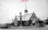
It’s Christ Church, Perry Barr - there’s a thread on the Forum
It’s on the OS map of 1884 -
https://www.british-history.ac.uk/m...=10073&ox=1410&oy=2708&zm=1&czm=1&x=138&y=368 .
Bill
It’s on the OS map of 1884 -
https://www.british-history.ac.uk/m...=10073&ox=1410&oy=2708&zm=1&czm=1&x=138&y=368 .
Bill
TOPSYTURVEY
brum
bill. Thank you. I Lived just passed there for 18 yrs . I am learning such a lot off this forum.
TOPSYTURVEY
brum
ZIG ZAG Bridge
.JPG")
S
Stitcher
Guest


Hello Topsy, I know someone who is interested in the Aldridge Road and immediate vicinity, he has given me this information for you.
This Bridge crosses the River Tame on the Aldridge Road quite close to Wickes I believe.
TOPSYTURVEY
brum
Thanks Stitcher.
S
Stitcher
Guest
The pleasure is all mine.
TOPSYTURVEY
brum
 One more of interest from the past.
TOPSYTURVEY
brum
Sorry the photos above should have been on another thread.
TOPSYTURVEY
brum
Lyn, They are very interesting. I think Perry Pont was roughly where the Dairy was . I would loved to have seen it in it,s hey-day.
TOPSYTURVEY
brum
Me to lyn, I bet it was fasinating. To think i lived right by there for 18yrs and never knew it existed, only remember The Dairy.
S
Stitcher
Guest

1928 and we are in Aldridge Road.
A view of Aldridge Road just before the University was built. I think Alexander Stadium is to the left (top). Viv.
S
Stitcher
Guest

Eric Gibson
master brummie
Buntings Garage was somewhere about there if I'm looking at it from the right angle.

Bob Davis
Bob Davis
In the Seventies, Jack Bunting up and moved from Birmingham to Totnes, the garage there was mainly run by his son, But Jack in the way of many an older company owner would be on the forecourt usually in a brown cow gown painting the pumps. Luckily he had a well established relationship with the local Forward Trust area manager and we were introduced, but the rep' who walked up to Mr Bunting and asked in a superior finance company reps voice for the boss or any other more impolite description of the proprietor got very short shrift and once the deed had been done there was no way back. Jack Kershaw was the Forward Trust area manager and he was a Birmingham manBuntings Garage was somewhere about there if I'm looking at it from the right angle.
Bob Davis
Radiorails
master brummie
Judging by the lamp standard near the garage suggests it is a major road; Walsall Road, Maybe?
Last edited:

Eric Gibson
master brummie
Buntings was on or near the corner of Wellhead Lane and Aldridge Road opposite to the Alexander Stadium (the original one) they were Austin agents, they went broke in the sixties I think.
Bob Davis
Bob Davis
He sold up and opened up in Totnes with his son, see post 543 above.Buntings was on or near the corner of Wellhead Lane and Aldridge Road opposite to the Alexander Stadium (the original one) they were Austin agents, they went broke in the sixties I think.
Bob
oldMohawk
gone but not forgotten
Two aerial views of the area ...
The first is dated 1950 and there appears to be a garage in the centre of the pic ... white building with a canopy (maybe added since prewar) in front but set back somewhat from Aldridge Rd. The large house bottom left has enough chimneys to match the building in the right of the original pic .... but other items seem hard to match ... enlarge the pic and scroll ...

The second dated 1937 is from another direction and resolution is low ...

from https://birminghamhistory.co.uk/forum/index.php?threads/christ-church-perry-barr.46014/#post-562538
both images from 'britainfromabove'
The first is dated 1950 and there appears to be a garage in the centre of the pic ... white building with a canopy (maybe added since prewar) in front but set back somewhat from Aldridge Rd. The large house bottom left has enough chimneys to match the building in the right of the original pic .... but other items seem hard to match ... enlarge the pic and scroll ...
The second dated 1937 is from another direction and resolution is low ...
from https://birminghamhistory.co.uk/forum/index.php?threads/christ-church-perry-barr.46014/#post-562538
both images from 'britainfromabove'
Last edited:


Today's maps show everything around Alexander stadium (now dog track) has gone since that time. I remember the stadium when it was still used as an athletics stadium. Must have been up until the 1970s ? Not exactly sure when it became a dog track. But wasn't there another track or stadium built in/near Perry Park after that ? Or maybe I imagined that. Viv.
Pedrocut
Master Barmmie
Today's maps show everything around Alexander stadium (now dog track) has gone since that time. I remember the stadium when it was still used as an athletics stadium. Must have been up until the 1970s ? Not exactly sure when it became a dog track. But wasn't there another track or stadium built in/near Perry Park after that ? Or maybe I imagined that. Viv.
Post 547 and oldm’s ariel view both show the old dog track and the sports stadium. The dog track moved to where it is situated today, being the sports stadium.
Somewhere there is a picture of the entrance to the old dog track leading down through the car park, and over a bridge on the river Tame.