• Welcome to this forum . We are a worldwide group with a common interest in Birmingham and its history. While here, please follow a few simple rules. We ask that you respect other members, thank those who have helped you and please keep your contributions on-topic with the thread.

    We do hope you enjoy your visit. BHF Admin Team
  • HI folks the server that hosts the site completely died including the Hdd's and backups.
    Luckily i create an offsite backup once a week! this has now been restored so we have lost a few days posts.
    im still fixing things at the moment so bear with me and im still working on all images 90% are fine the others im working on now
    we are now using a backup solution

Across Birmingham on the 29A

ellbrown

ell brown on Flickr
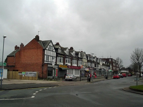
I was in WH Smith in Solihull today and I saw a book by David Harvey called Across Birmingham on the 29A.
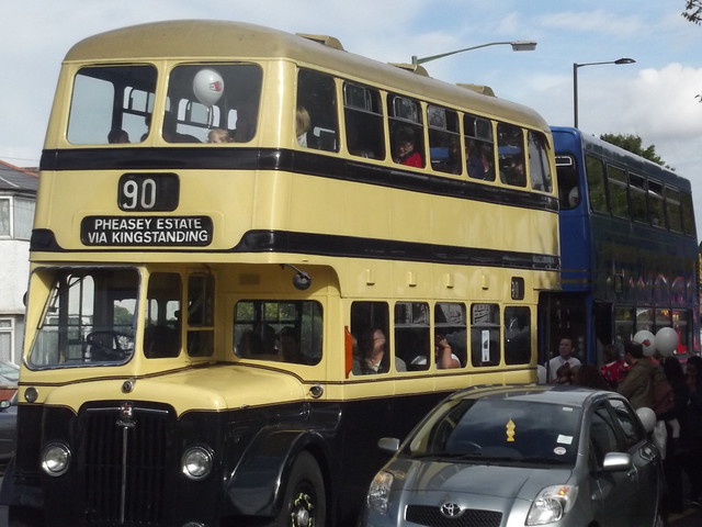
Most of these routes were before my time, but also mentions the former 30, 33, 90 and 91. The modern day 5 and 6.

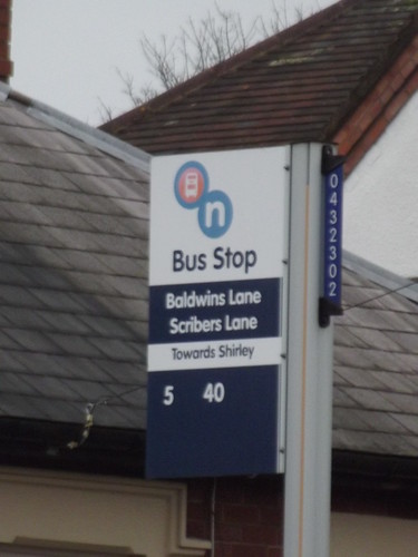
Strange that these routes also went to Kingstanding, when the current ones pass through Hall Green on the way to Shirley and Solihull!

DSCF6660.jpgDSCF6661.jpg
 
Thank you for bringing the book to the notice of Forum Members. The 29A (and most of the routes that used Stratford Road, both BCT and Midland Red, were well known to me up until 1954.
I have a few of the splendid books of the erstwhile BCT written by David Harvey and I look forward to getting this one.
 
It's looking good so far!

These days the only Cross-City services are on the train, not the bus!

I'm sure before the 5 was the 4, but the book makes no mention of the 4.

Few days ago I got a 5 from Shirley, and it turned down Haslucks Green Road, and headed towards The Baldwin, before going onto the Robin Hood Lane.
Think the 76 goes straight from Shirley up the Stratford Road and turns left onto Robin Hood Lane from the Robin Hood Island.
 
The kind of bus featured in the book. Seen as a 90 during last autumns Open Day between Acocks Green and Yardley Wood bus garages. Formerly a 29 or 29A.

 
Not sure if anyone checked the mistakes in this book. He is calling Cole Bank Road - Sarehole Road (outside Sarehole Mill). They only turn right onto Sarehole Road at the island after Sarehole Mill!
 
Ah! well, I am more interested in the pictures that the script as I was very familiar with the route more so the souther and city part (south of Hockley). Looking at the Google map it seems to me that the route is unchanged: the bus stops seem to be pretty well were they were sixty years ago. The only section of Cole Bank Road that I recall and see is where buses use the part between the roundabout (junction with Sarehole Road) and the other roundabout (junction Wake Green Road). Cole Bank Road of course was the preserve of the Outer Circle route 11.
Two things I remember about this area. Firstly I had an uncle who lived in Swanshurst Lane, overlooking the roundabout, secondly the other was about a woman who attempted to board a 29A bus at the Bundy clock in Cole Bank Road as the bus moved off. She did not make it but clung to the vertical platform stanchion and was not noticed until the bus had navigated the island as was starting to accelerate into Sarehole Road. I believe she was in hospital for some while.
 
The pictures are good.

This morning I decided to walk down to Baldwins Lane. Saw the 5, but kept missing it (catching it that is).


One of the photos in the book is dated 1966, the year that Baldwins Lane Service Station / Garage opened!


Roundabout - original terminus of the 29A.


The Baldwin pub - now owned by Hungry Horse


Built 1937.
 
Yes the road layout of Wake Green Road, Swanshurst Lane and Cole Bank Road is pretty much the same (other than a change in street furniture).

View of Sarehole Mill from Cole Bank Road


Hungry Hobbit - a cafe near the roundabout (between Wake Green Road and Swanshurst Road).


The bridge on the River Cole. View from the 5 / 11A bus stop


Other side of the River Cole bridge in snow

 
I remember the 29a at the Kingstanding end it went up and over Kettlehouse and down to the terminus at the Trees Pub on the Queslett Road.
 
How pleasing to see those pictures El. There are some changes at Baldwins Lane although Cole Bank Road was quite recognizeable. I guess the Bundy Clocks have gone in both locations. Sarehole Mill was very concealed from Wake Green Road when I remember it, in fact I did not know that the mill was there. I think the entrance structure to the Baldwin has spoiled a very smart building. How on earth do the planners allow it?
In one photo, of the row of shops, the one nearest to the camera was an elliptical retailer. After WW2, about 1947/8 I guess, they had a OO model which was red London Transport tube stock. I don't remember if there were two or three cars in the set. Oh! how I wanted one, but never did get one. :biggrin: In later years I did amass a large collection of HO/OO models but never had space to build my ideal set up. I sold it all and now have a garden railway.

There is a pic of a bus (rear view white): is that in Newborough Road? The one (front view red) is the same road or another , such as Acheson Road. Acheson Road would, in my view, not be ideal. An unfamiliar driver might turn right, by mistake, getting his vehicle wedged beneath the railway bridge.:redface:

Of the most well known BCT routes I guess would be the Outer Circle 11, Inner Circle 8 and Baldwins Lane and Kingstanding 29A, in that order.

Edited to change road name 2/28/14
 
Recently the mill was restored (again) and the pool was dredged last year!

Normally you can see Sarehole Mill over the gate on Cole Bank Road. It is still difficult to see it from Wake Green Road (trees and shrubs in the way). But there is a new wooden fence around the site!

Wake Green Road - dredging- Dec 2012


The same view last year during the Open Day (October 2013)


From the decking around the pool


Wake Green Road - Gracewell Cottages - Tolkien lived at no 264

 
Don't think The Baldwin is listed. Therefore Hungry Horse could build an extension onto it!

A few details


When I was 14yrs old I started working at Cannings and I would wait in line every morning on the Kingstanding Circle to get the 29 or 29A into town come rain or shine. I remember one time in the evening when we left work at 5pm. it was so foggy the buses weren't running and we had to walk all the way home to Kingstanding and you could hardly see a hand in front of you. It took me about one and a half hours to eventually make it to our front door.

Have a nice day, Wally.
 
Did anyone go all the way from Kingstanding or Pheasley to Hall Green? (and vice versa). Assume everyone got off in the city centre! No wonder the routes were eventually split into two!
 
I remember the 29a at the Kingstanding end it went up and over Kettlehouse and down to the terminus at the Trees Pub on the Queslett Road.

Later they moved the terminus onto the Pheasey Estate, at junction of Hillingford Av and Collingwood Drive
 
Yes, on reflection it was a subtle on the destination blinds change. Originally it read Baldwins Lane and Kingstanding but obviously that was changed to read Baldwins Lane and Pheasey Estate when the extension was made.
 
Last Friday I saw a broken down bus on Moor Street Queensway, that may go to Pheasey. 934 or 935.


It probably also goes to Kingstanding!


Theoretically you can change your bus at Moor Street Queensway, (one of the Stratford Road routes - get off at Carrs Lane or on near here). And change onto a Perry Barr bound bus! (and beyond).
 
Did anyone go all the way from Kingstanding or Pheasley to Hall Green? (and vice versa). Assume everyone got off in the city centre! No wonder the routes were eventually split into two!

Only as a joyride, It was always interesting to see what existed beyond Perry Barr speedway stadium. :biggrin: It reminds me of the London comment that those living south of the Thames would cross the river to see if there was life over there.
 
I have ammended my post 13 to show what I believe is the correct road name. WOW! I had a girl friend who lived in that road ( we were both school age, so nothing serious I guess) so I should have remembered the road name. :biggrin:

My book, of the tiltle of this thread, arrived yeasterday. I have only looked at the photos so far. Two or three things drew special attention. They were photos of my favorite BCT buses: piano front AEC's and FON registered Leylands. These were very rare on the routes in my time. The other favourites, which were by no means rare, were the HOV Leylands - aka bouncing buses. Anyone traveling on one down Robin Hood Lane will know what I mean.

Another interesting picture was bus HOV 699 (car 1699) which overturned when turning into Highfield Road from Stratford Road. This surprised me as the roads were wide there. A more likely place for such an incident would have been the difficult turn from Robin Hood Lane into Keddleston Road which always caused buses - especially when well laden - to heel over.
 
ref # 17
"Did anyone go all the way from Kingstanding or Pheasley to Hall Green? (and vice versa). Assume everyone got off in the city centre! No wonder the routes were eventually split into two!"

I used to travel the whole route during the school holidays as we lived in Blythsford Road, just off Newborough Road, and I used to take my children to Barr Beacon for the day. We used to take a picnic with us and have a grand time.

I used that bus route from the 1946ish up until 1978 when my Mother moved from Blythsford. I had no choice but to use that route and a couple of years ago had to use the 4 from Solihull to Sarehole and the journey was an absolute nightmare. I complained to the driver who told me I didn't have to ride that bus!

I remember when young and travelling from Stechford on the number 11 (on the old Routemaster type) chasing the bus to Southam road. We often used to hop on the bus by catching the pole on the platform as the bus went round the island, but this time I had missed it and my Dad had jumped on. The conductor held the bus up until I arrived at the Bus Stop - that was service, specially as we had not boarded at an official bus stop.
 
Since I bought the book last week, I keep spotting the no 33 bus in the city centre! I think they usually say Pheasey on them, but they may also now go onto Walsall!

They look like the modern red and white Enviro 400 buses. With a green strip on them!
 
I don't know when the numbers were reassigned, but the current 29 goes from Colmore Row to Northfield, via Broad Street, Harborne and Weoley Castle. And the modern 29A goes to Shenley Fields. Both routes also pass through California!
 
I don't know when the numbers were reassigned, but the current 29 goes from Colmore Row to Northfield, via Broad Street, Harborne and Weoley Castle. And the modern 29A goes to Shenley Fields. Both routes also pass through California!

Changing about route numbers is a right pain! For me a 5 should go to Perry Common and a 6 to Sandon Road etc. At least NXWM still recognise California as the name sadly no longer appears on current O/S maps and Google Earth.

Simon
 
I went on a 33 last week from Perry Barr to the City Centre (Aldridge Road to Moor Street Queensway), then a short walk up to the 6 (to head to Hall Green and home).
 
Changing about route numbers is a right pain! For me a 5 should go to Perry Common and a 6 to Sandon Road etc. At least NXWM still recognise California as the name sadly no longer appears on current O/S maps and Google Earth.

Simon

I wouldn't know about those routes (before my time). Are they the 934, 935 and 936 now?

Also before the current 5 (Birmingham Carrs Lane to Solihull Station via Widney Manor Station) there used to be the 4 (that went past Sarehole Mill). Not too long ago!
 
Nothing terminates in Sandon Road these days but some routes travel up it. The old 5 and 7 were cross city and were the same route going in opposite directions, these days it operates just from Colmore Row to Perry Common and is numbered 7 whatever direction it travels, in the past buses travelling to Perry Common were 5 or 5A (two different termini) and for the return journey to Portland Road the number 7 was used.

It was before my time visiting Brum too but I have a lot of interest in the history of the bus routes.

Simon
 
Whilst visiting my parents in Perry Barr last weekend, I had to pass The Scotts Arms. I my be wrong, but I am sure I saw the West Bromwich to Sutton Coldfield now numbered 5. if my memory serves me right, I think it used to be the 456, right back to West Bromwich Corporation days.
 
Back
Top