Follow along with the video below to see how to install our site as a web app on your home screen.
Note: This feature may not be available in some browsers.
Welcome to this forum . We are a worldwide group with a common interest in Birmingham and its history.
While here, please follow a few simple rules. We ask that you respect other members, thank those who have helped you and please keep your contributions on-topic with the thread.
We do hope you enjoy your visit.
BHF Admin Team
HI folks the server that hosts the site completely died including the Hdd's and backups.
Luckily i create an offsite backup once a week! this has now been restored so we have lost a few days posts.
im still fixing things at the moment so bear with me and im still working on all images 90% are fine the others im working on now
we are now using a backup solution
Does anyone know why Warstock Rd is so wide were there ever any plans to link it up to any other roads or make it a major highway.Thanks inn advance for anyones help
I understand that Birmingham Corporation had a grand plan for a road system that included a network on duel carriageways across the city.
The scheme was started in a number of places but fully completed. There apparently were plans to build two road tunnels under the city centre to. It seems in those days there was a lot of joined up thinking, Corporation gas works, electric, sewage, banking, housing, water....
A few years ago I did read a book published by Cadburys which outlined a development plan for Birmingham, however like all best laid plans....
I've always understood it was part of a "Grand Road Plan", it's possible to trace a route that may have been used from Acocks Green to Stirchley where the road is either dual carriageway or wide enough to be, there are however a few points that it would have required widening.
Does anyone know why Warstock Rd is so wide were there ever any plans to link it up to any other roads or make it a major highway.Thanks inn advance for anyones help
I've allways wondered about that. Highters Heath lane is also very wide and I've often thought that it looks like there was a plan to link the two up.
Certainly HH lane goes on to join the Alcester road.
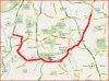
Hi Morturn. The book you mention might have been "Our Birmingham" first published by Cadbury's in 1943. In the 1950 edition it says that it was planned that Bristol Rd would be a double road, with trams down the centre. The map below shows how much of it was developed. In this case, the reason it was not all developed was because, when Selly Oak and Northfield were villages, the houses were built close up to the side of the country road. The cost of compensation to the owners of the houses was considered too high and prevented the council from completing the new double road. Interesting subject. Viv.
Hi Viv, yes that seems to ring a bell; I recall thinking that the scheme did seems very good, but would have been very expensive due to the number of houses they would need to demolish.
There is a short section of duel carriageway and wide verges on the Yardley Wood Road near where I live. There was also a section on Streetley Road Erdington, the wide verge continues across the Short Heath road, but as a single lane all the way to Witton Lodge Road.
The Walsall road from Perry Barr to the canal bridge at Tower hill was also left wide enough for duelling, which eventually was completed a few years ago.