-
Welcome to this forum . We are a worldwide group with a common interest in Birmingham and its history. While here, please follow a few simple rules. We ask that you respect other members, thank those who have helped you and please keep your contributions on-topic with the thread.
We do hope you enjoy your visit. BHF Admin Team -
HI folks the server that hosts the site completely died including the Hdd's and backups.
Luckily i create an offsite backup once a week! this has now been restored so we have lost a few days posts.
im still fixing things at the moment so bear with me and im still working on all images 90% are fine the others im working on now
we are now using a backup solution
You are using an out of date browser. It may not display this or other websites correctly.
You should upgrade or use an alternative browser.
You should upgrade or use an alternative browser.
Upper, Middle And Lower Witton Reservoirs.
- Thread starter Pedrocut
- Start date
The old building may have looked on the inside just like the one we are trying to save at Sandfields in Lichfield. We think that (to be confirmed) the beam engines were built by the same Tipton company. So we know what the building would have looked like from the inside.
Have to say, the new building is a bit bland
Have to say, the new building is a bit bland
Pedrocut
Master Barmmie
The old building may have looked on the inside just like the one we are trying to save at Sandfields in Lichfield. We think that (to be confirmed) the beam engines were built by the same Tipton company. So we know what the building would have looked like from the inside.
Have to say, the new building is a bit bland
In one of the papers it gives a detailed account of the sinking. I will try and find and post.
Lady Penelope
master brummie
There was another, smaller, lake on the other side of Bleak Hill and this whole area was named as 'The Bogs' on earlier maps.
Pedrocut
Master Barmmie


A couple of maps from the National Library of Scotland to show the course of Hawthorn Brook on its route to Upper Witton Pools, and from what I presume may be its source near the King’s Vale Pumping Station. The older is from the mid 1880s.
On the 1880s map it shows the Brook running to Lodge Pool, and then to a smaller pool before reaching the Upper Witton Pools. Looking at the map for around 1901 Lodge Pool now seems to be a swamp and a Hydraulic Ram is indicated. The smaller pool is marked as a Swimming Bath.
By 1913 Lodge Pool has disappeared, but the Swimming Bath still exists. In 1938 the Bath remains but the Hydraulic Ram has gone. There is also a stream flowing from a fish pond that joins the Brook just above the swimming Bath, the fish pond still exists in 1938
Pedrocut
Master Barmmie
There was another, smaller, lake on the other side of Bleak Hill and this whole area was named as 'The Bogs' on earlier maps.
All these pools are just a spit from Lake House!
and is that the newer waterworks building on post 22 mort...looks disused now
It is, electric pumps. I have a feeling it is still an operational site. The modern sites don't need to be manned now, all automatic with the occasional mintenance vistis.

Yes, King’s Vale Pumping Station was just behind the TSB bank on Kingstanding Road. I think its gone now. There was another water works at the Top of Rough Road, I think it was Perry Wells (?).
Hawthotn Brook split in Kingstanding, one branch ended in Finchley Park and the other around Warren Farm Road by the old baths.
Hawthotn Brook split in Kingstanding, one branch ended in Finchley Park and the other around Warren Farm Road by the old baths.
Nice find Pedrocut. Quite an unuseual engine for a waterworks, I wonder if it was a bull engine?

Lady Penelope
master brummie
Yes Pedro, there's a rivulet which appears to flow into the small Baldmore Lake and then down parallel with Goosemoor Lane before joining the brook at Marsh Lane.
Morturn, the swimming bath belonged to the college and they had lots of sports facilities (to keep their young minds occupied I suppose.....). I was reading a history of the college the other day and apparently they played the very dangerous game of 'bandy' up in the woods in Kingstanding. Like hockey possibly but with trees in the way - hence Bandywoods.
Morturn, the swimming bath belonged to the college and they had lots of sports facilities (to keep their young minds occupied I suppose.....). I was reading a history of the college the other day and apparently they played the very dangerous game of 'bandy' up in the woods in Kingstanding. Like hockey possibly but with trees in the way - hence Bandywoods.


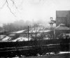
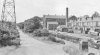
Here are some images of the Salford Bridge engine house. Again a Cornish engine, it look like its working in one image. I did go in this engine house in the 60's before the motorway was built.
You can see the pipleine across the river
You can see the pipleine across the river
Attachments

Pedrocut
Master Barmmie
In December 1857 there was concern over a breach in the embankment of the new reservoir Witton pool. Some personal danger and local flooding occurred, but fortunately without loss of life. Fears had been raised by the earlier disaster of 1852 at Holmfirth which caused 81 deaths.


Last edited:
Lady Penelope
master brummie
Very interesting Pedro - wonder where Mr Dugard lived?
Pedrocut
Master Barmmie
Very interesting Pedro - wonder where Mr Dugard lived?
March 1858 informs that the breach was at the lower of the Upper Witton Pools. This may indicate that it was the "middle" reservoir, and maybe the water would flow down Gipsy Lane?


If you go to post 10, a map of the proposed formation of the reservoirs dated 1854 (enlarged section below for ease of view), then it can be seen that just at the top of what would be gypsy lane, was to be built an embankment, so this would be the bank referred to which was breached


Pedrocut
Master Barmmie
In the Bill seen above there is a good description of the old field names around Witton Lakes and Brookvale Park, for example Bleak Hills, Middle Slade and Lower Slade. Bleak Hill can still be seen, and maybe Slade gave its name to Slade Road. A good picture can be built up of the area around 1854.
Radiorails
master brummie
A 'Slade' is another word for valley, which is where the lakes were built.
Pedrocut
Master Barmmie
Very interesting Pedro - wonder where Mr Dugard lived?
Here is a section of the modern OS Explorer Map. I have highlighted the 100m contour which seems to stretch from the embankment on Witton Lakes and around Brookvale Park. Also highlighted are the 105 and 110 m contours.
The distance from the embankment to Brookvale Park is roughly half a mile, being the distance that the Navvy wagons were swept. The valve was closed in the Lower Witton Pool which was under construction and the greater part of the water escaped into the pool.
Was the house of Mr. Dugard at Faulkner’s Farm on Gipsy Lane? And where were the Aston Schools that were flooded?

Lady Penelope
master brummie
Pedrocut, that's a really good map. I found a Mr John Dugard living at Witton Cottage on the 1861 census.