• Welcome to this forum . We are a worldwide group with a common interest in Birmingham and its history. While here, please follow a few simple rules. We ask that you respect other members, thank those who have helped you and please keep your contributions on-topic with the thread.

    We do hope you enjoy your visit. BHF Admin Team
  • HI folks the server that hosts the site completely died including the Hdd's and backups.
    Luckily i create an offsite backup once a week! this has now been restored so we have lost a few days posts.
    im still fixing things at the moment so bear with me and im still working on all images 90% are fine the others im working on now
    we are now using a backup solution

New unseen photos with no locations

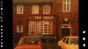
It is without a doubt the Tree Bristol Rd that was adjacent to the Bristol Cinema, when they demolished the old Trees they first built the new replacement tree in front of it. When the new one was built they opened the new one and closed and demolished the old one without losing a moments trade.
 
There were a few 'Trees' it seems in the area. The Trees Queslett Rd, and The Trees Castle Vale and The Trees Wheelers Lane.
 

Attachments

  • The Trees  queslett rd great barr.jpg
    The Trees queslett rd great barr.jpg
    79.4 KB · Views: 53
  • The Trees castle vale.jpg
    The Trees castle vale.jpg
    33.2 KB · Views: 56
  • The Trees Wheelers Lane Bath Row 1965.jpg
    The Trees Wheelers Lane Bath Row 1965.jpg
    109.2 KB · Views: 55
thanks for the idea john..thanks for the photo jim and thanks phil for comfirming...i agree it is the trees on the bristol road..

thats another one sorted and quicker than i thought it would be...

lyn
 
Whilst it a bit quiet on this thread if no one minds I'll put a photo up thats been nagging at me for a while now. I picked this up whilst searching the web some time back. Although it wasn't tagged with a location I thought I know where that is, but looking closer I realised that it wasn't Melvina Rd Nechells as I first thought. Whilst there is not much doubt to roughly where it is, can anybody tell me exactly.
 

Attachments

  • Unknown.jpg
    Unknown.jpg
    75.8 KB · Views: 81
Whilst it a bit quiet on this thread if no one minds I'll put a photo up thats been nagging at me for a while now. I picked this up whilst searching the web some time back. Although it wasn't tagged with a location I thought I know where that is, but looking closer I realised that it wasn't Melvina Rd Nechells as I first thought. Whilst there is not much doubt to roughly where it is, can anybody tell me exactly.

Phil, the photo slide of Gt Francis st Duddeston was scanned back to front here we are this is how it should look

gt Francis st-saltley rd.jpg
 
Pudding

Yes of course that's it, thanks so much. It's immediately recognisable now, Why couldn't I see that? whoever scanned it and put it on the web couldn't have known the location.
 
Below is one where Phil has suggested a location , but was not sure, though it was taken after one of the Stratford arms in Kyrwicks Lane , which would make his atribution likely. Wwould be nice if someone else finds it famiiar.
The three-quarters-covered name on the shop to the right of centre reads Thompson. There is an S.J. thompson in Deakins road, but this seems unlikely. Phil has suggested that it might be Kyrwicks Lane, and there was a Lilian Gertrude Thompson , shopkeeper, at 97 Kyrwicks Lane, which fits with the parts of the remaining letters that can be seen.


37A__L_G__Thompson_97_Kyrwicks_Lane.jpg
 
mike it looks like there is another letter before the word thompson...poss a c ..would you have a map showing no 97 kyrwicks lane and the properties either side so that we can compare the layout

lyn
 
Last edited:
Re. post 244. it's a Phyllis Nicklin image Phil and the caption to it was Duddeston, near Loxton Street. Viv.
 
Last edited:
The large scale map c 1950 is below

map_c_1950_showing_97_kyrwicks_lane.jpg


The 1889 map is rather clearer and virtually the same in this immediate area

map_c_1889_showing_97_kyrwicks_lane.jpg


The alleyway to the left of the shop and to the left of the next but one shop fits with the map, while the right hand side of what would be no 95 seems clean , which would fit with it being the edge of St James Place.
 
Re. post 244. it's a Phyllis Nicklin image Phil and the caption to it was Duddeston, near Loxton Street. Viv.

Vivienne

Now pudding has flipped the photo I have no difficulty in placing it, in fact it was just adjacent to Loxton St before it disappeared it was on Great Francis Street they later renamed that end of it as Little Hall Rd. In fact if you look at the block of maisonettes the third window from the left on the ground floor just before the door became a mates bedroom in the early sixties when his family moved into the block.
 
Mike

I'm even more convinced than ever that the photo is of the shops on the left of Kyrwicks Lane that I passed on the way to the Hereford Arms each night after they closed the Talbot at the top of Larches Street.
 
Certainly the map fits it being them. We will wait a day or so to see if anyone else has any other confirmation and if there is no alternative we will then take it as that
 
What a fantastic photo, Mike. As a photographer of the urban scene myself I love the look of utter ruination, the textures of decay: sagging roofs, gloomy doorways, windows broken or barricaded - and always a foreground of scrubby wasteland. There appear to be curtains in an upstairs window, so presumably the place was still inhabited by someone grimly hanging on... I love it!
 
Re Mike's post 193, it looks like a row of back houses in Catherine Street, off Lichfield Road, Aston, and the large factory could be Buttons.

Re the mystery pub which turns out to be the Crown, I feel rather ashamed at not being able to identify it earlier, in the late 50s early 60s my ex-husband's best friend was courting and later married a girl who lived there. Her dad Bill Edmonson was the licensee. I always thought it was the Church Tavern so may have my wires crossed, it was a long time ago. Perhaps it can be confirmed from one of our more knowledgable friends.

Good thinking, Sylvia. What did the Buttons factory actually make? No, surely not buttons...
 
The first of Mike's photos n post #193 has an unusual architectural feature. There's a fascia (which looks like a horizontal barge board) running along the lower edge of the roof. The house would once have adjoined another house to the right. Wonder why it had that extra decoration. Does it indicate it's a pub? (To me it's very reminiscent of the boards decorating roofs at railway stations). If it's a pub, would it have been slightly odd to have the decoration on the rear of the building? It certainly looks like it was an added decorative feature to make the building stand out. Or maybe this isn't the rear of the building? Maybe this is a front view with the houses having extra fascia decoration because they formed the centre of a symmetrical row of cottages with the right-hand side of the row reflecting what we can still see on the left side.Viv.

View attachment 98030

I still can't quite understand what's going on at the extreme right of this picture. Adjoining the peculiarly barge-boarded house is a sort of outhouse with a tall chimney, backed by a brick wall almost as tall as the highest point of the end gable. The upper bit of this wall (and chimney) is of lighter brick and appears to be an addition. What is the necessity for a wall so tall? And beyond that, there appears to be another wall which may be the side of a building we can see just above the roofs in the terrace.

And where is the road access? Between the two walls? And if we are looking at the rear of the terrace, the back doorway looks unusually substantial, with a recessed stone dressing...
 
Exactly the questions I have asked myself about this photo Viewfinder. I'd assumed the cottage with the decorative barge board was one of two - i.e the original row of cottages would have mirrored the cottages we see in the photo to the left. The additional decoration must have had some meaning. I thought perhaps this would be the centrepiece of the row of cottages. This is why I thought they might be almshouses, particularly as the doorways have arches. Alternatively the cottage(s) with barge board (s) may have had some other significance.

And I've struggled with those walls too. I first thought the tall wall was probably between cottages, with another row of cottages backing onto the ones in view. But don't think so. Think there's another row of cottages attached directly to the back of the cottages in view. And the wall is probably opposite those. Think it might be a trick of the camera making the wall appear directly attached to the cottages in view.

Viv.
 

Attachments

  • image.jpg
    image.jpg
    184.4 KB · Views: 73
Last edited:
Good thinking, Viv - but surely the high wall is indeed directly connected to the cottage with the bargeboard. The single-storey annex is obviously connected, and its tall chimney is attached to the high wall. Just to the right of the chimney is an aperture and a down-pipe that clearly takes a detour on the annex roof and tips in to the gutter. The existence of this down-pipe indicates that this is more than just a dividing wall, instead the back of a structure that has a roof requiring drainage. Perhaps the lighter-coloured, upper part of the high wall is a parapet, and what we thought was another wall beyond is, in fact, a pitched roof. But then, this doesn't seem to tally with the building visible over the roofs of the rest of the terrace...
 
Looking closely at the distinctive building, the 'chimneys' seem to be brick rather than the usual metal chimneys or ventilators used on workshops and which were often topped with conical metal caps. As previously mentioned the houses have unusual windows and although I have looked at many old street pics on the forum I haven't yet found any similar houses. I notice that the houses seem to be on a hill sloping towards the distinctive building. The house with the decorative fascia board has the same window design as the adjoining houses and has the back garden near the house fenced off.

The uhf tv aerials on the houses must be pointing at the Sutton Coldfield transmitter but any hope of finding the direction of the road depends on where the road is in Brum .... clutching at straws here ...
friendly_wink.png
 
Thanks Viewfinder. Had another closer look and I think it's possibly two walls, hence the different coloured bricks. The lower part might be between two cottages in view with them being backed by another row of cottages on the other side. Maybe if it's a second wall it's another separate row of cottages with a similar arrangement. The exposed chimney could be the chimney to an original cottage (like the barge board one) but the cottage having been removed some years before. Agree the outhouse looks like it was being used for a particular purpose. Viv.
 
Interesting, Viv. About the change in tone of the bricks: I can't immediately see that this indicates the existence of two separate walls, because the chimney breast clearly occupies both the lighter and the darker areas. An inspired thought of yours, suggesting that the chimney is the remnant of a now-demolished house. I wonder if we are looking at the front elevation of the terrace (a decorative barge-board at the rear might be unlikely), which is served by a path at the end of the gardens.
 
Thanks Viewfinder. I've enlarged the area of the the end of the roof and the wall. It doesn't look to me that they are attached to each other. And I wonder if the chimney is actually attached to the wall at all.

And there's further decoration along the walls to the left. This seems to confirm your idea that this is the front elevation of the cottages. The different decoration suggests to me it was part of a longer terrace with a particular pattern to it. Viv.
 

Attachments

  • image.jpg
    image.jpg
    62.1 KB · Views: 57
  • image.jpg
    image.jpg
    45.2 KB · Views: 52
Last edited:
Thanks, Viv. I suggest that descending from the sky to the right of your red arrow, the first horizontal band is a pitched roof. The second band is a parapet atop the wall attached to the end cottage.

I note the white horizontal bands above the door on the left of the photo - probably purely decorative, as you say. And the stone-dressed pointed-arched doorway does indeed resemble almshouses or an ecclesiastical place. This is a fascinating puzzle.
 
I agree Viewfinder about the roof and parapet.

The arrangement of pathways and gardens don't really make sense to me. There's a washing line pole to the left, which suggests a back garden. We concluded that the view of the cottages us a front elevation, but the gardens seem to contradict that. Because of this I wondered if the cottages were originally designed around a square, with gardens in the centre. Can't work it out at the moment.

I also wondered if the houses were built by a known philanthropist. If so, it might make it possible to find an exact location. Viv.
 
Last edited:
An eagle-eyed spot, Viv - the washing-line pole on the left, indicative of a back garden. There is at least one pole in the garden of the barge-boarded house, too. Like you, I am trying to follow the path that leads away from the photographer's vantage-point, along the side of the broken fence. It seems to do a sharp left, running between fences, but what happens when it approaches the white fence? A dog-leg to the right towards the central tree, then left again, parallel with the rest of the terrace? Note also the brick lean-to with a corrugated iron roof, centre-left; again, would be unusual in a front garden.

The plot on the left foreground, which may be overgrown or reserved for vegetables, doesn't appear to be connected to the terrace. Could this be attached to a house behind and to the left of the photographer? Those recessed windows intrigue me, too. They, and the pointed-arched door, seem too fancy for the usual artisans' or factory-workers' cottages. I like your theory about a philanthropist, or a benevolent industrialist...
 
Have tried to find picture of the catherine st area on Britain from above, but finding it very difficult. The nearest seem to be lots of the /British Timkin factory in Cheston road.
 
This (blue dot) is roughly where I think two of the photos were taken. I've marked the OS Godfrey 1917 edition map with corresponding dots on the photos to show where the buildings are on in relation to the map. I think the Catherine Street view is, unfortunately not quite at the right angle to see the factory. The view is probably a little too far down Catherine Street. Buttons Ltd was an amalgamation of several button manufacturers brought together to fight growing international competition. Viv.
 

Attachments

  • image.jpg
    image.jpg
    359.2 KB · Views: 41
  • image.jpg
    image.jpg
    316.8 KB · Views: 42
Last edited:
Back
Top