• Welcome to this forum . We are a worldwide group with a common interest in Birmingham and its history. While here, please follow a few simple rules. We ask that you respect other members, thank those who have helped you and please keep your contributions on-topic with the thread.

    We do hope you enjoy your visit. BHF Admin Team

1865 Birmingham panorama

BordesleyExile

master brummie
This 1865 panorama is quite unlike any that I have come across. It has an intriguing foreground and the multitude of smoking chimneys illustrate how bad the air quality must have been.
Does anyone know where the artist would have been standing to capture this view?
 
18652520Brum_A.jpg
I have tried to make the panorama a little clearer, though it might be slightly distorted because of it. To me the railway l ine in the background looks like Great Western line into Brum going towards the tunnel.the line in theforeground is curved. As far as I can see the picture is about from where my red arrow is on the 1851 and 1866 maps. there are no quarries are shown where they are on the panorama, but it is empty in 1841, and garrison st in 1866. Slightly to the east are quarries in 1866, so between the dates of the maps there may be quarries at this point. I think it must be around there , though maybe not at the exact point of my arrows


map_1851bordesley.jpg
1866_bordesley.jpg
View attachment 64598
 
Thank you, Mike. The picture is far clearer, whatever it was you did to it. Thank you too for identifying the location & providing the maps. Its rather a treat to link the view to a hitherto neglected area in 1865. Its difficult to imagine such enormous brickworks ever having been there.
 
mike my guess was saltly way..brillient decuction by you..thanks very much i dont know how you do it...think i will stick to searching for pics and posting them lol...

lyn
 
Lyn I'm not absolutely certain .I don't have any direct evidence that there was a quarry where one is on the photo, and I am a little worried that my guess would make the view looking towards the south of the centre of birmingham (though there is no reason why it shouldn't, I would have expected it to look towards the centre directly)
Mike
 
well at least you have given us something to think about mike...

cheers

lyn
 
I think you have it spot on mike and it does say tile works for the quarry and I would have put money on it being a brick or tile works with all the clay holes in foreground
paul
 
Mike I agree with you almost on the location as I feel the Viaduct in the Distance is the Vauxhall Viaduct I am a little worried about your arrow position as I think the railway there is built on an embankment and not arches. When you travel up Landor St the arches finish a hundred meters from Lawley St.have a look at the google map to see if i,m in the right place and give your opinion. Dek
 
Mike

I think the large square building centre right of the engraving is Curzon St Booking Hall and the buildings in front are the station itself. The structure to the front is the viaduct in to Snow Hill in the process of being built. Therefore the view would be from somewhere along the High St in Digbeth.

Phil
 
the viaduct is definatly in the middle of construction and not yet a perminant way I would also say it is the westerly entrance for snow hill.
 
Theres people on here with more idea of the history and geography of the area than I have, but if I had to guess, and from a quick look at Google Earth, I'd say its from around the junction of Hack St/Heath mill La, looking toward the blues ground. if we could locate the 'square arch' thats in the bottom centre of the picture it might help.
 
I'm basing my supposition on this earlier drawing of the rear of Curzon St Station, it show a remarkable similarity to that what I pointed out in the engraving and don't forget that some thirty years later it would have been built up more.

Phil

VauxhallCurzonSt1834.jpg
 
Actually the St Andrews location if correct is not that far from Curzon Street but the building in question is not quite in the right direction in the view and 1229 yards away. The viewpoint proposed is on a bluff above the railway which is why the view of the bridge/viaduct is below and this may give a sighting of Curzon Street Station.
 
I have gone off the St Andrews location a bit. It is just taking too much bending to match and Phill's argument is compelling. I think out there in that WW1 like terain a lot is going on and thinking that the structure may have been buried is a bit of a stretch. The Curzon Street station is too hard to ignore but what is the structure? I am begining to think that the structure is in fact the notorious Viaduct that did not get used for much...maybe storage underneath. The last bit, if it were ever built, is not there anymore but it never did make a full turn and seemed to end abruptly at the Curzon Street tracks. So that the bridge on the right of the picture would be where the canal went under the Curzon Street tracks. The immediate view of the viaduct would possibly be over the river Rea and the tunnels in the mid distance left would be carrying the Rea under the Warwick & Birmingham canal. It's hard to tell water in monotone sketches. Certainly Curzon street is then in the right location and closer.
So...option 2. A view looking west from Montague Street...how the vantage point elevation was attained is unknown. I don't think that there were ever any tracks on that Viaduct...it seems to me it was a mistake and amazingly is still there today. Bear in mind that the current day tracks do not go into Curzon Street but run along side so that the bridge over the Birmingham canal would be further back...back then. Some refs.....

https://www.british-history.ac.uk/m...=10098&ox=3717&oy=1268&zm=1&czm=1&x=605&y=196

GE Montague street
GE for the far side of the culvert (a nice picture is there)
 
You can go to the picture location on Montague Street and pretty well see most of the features in the picture today. It has not changed much and there is still a piece of the Viaduct remaining...at least when the last Google photo's were made. The useless Viaduct still stands like a Roman ruin except it is a Viictorian one. Maybe a picture could be taken showing the exit of the Rae from under the canal....a good forum project perhaps. If you look on Google at where the Rae goes under the canal 174 Fazely Street there is a great picture of the back of the small duct and three little arches can be seen reflected in the water I think. Curzon Street train sheds have gone though but the monolithic admin. office is still there. I think that the orignal Birmingham Canal tunnel construction is still there beyond the later side addition. The building in the centre just to the right of the fold is the Gun Barrel proof House...still there now and picture from canal on GE. The useless Viaduct is probably a bird santuary. Small trees and large bushes grow on it for most of it's length. What a monster construction to make for nothing.
 
I,m still a bit confused. Is the hill in the background B,ham Town Centre? Is the Viaduct in the background going up to Moor St?Dek
 
Yes, I believe so. and the sheds and solid building right centre is Curzon Street station as Phill suspected. First impressions of the picture formed for me the thought that it was a large area but it is not and thinking that it is a relatively small space makes the proposed location plausable. The church tower and spire right centre is not St Martins but a church/chapell in Meeting Street/Dale End perhaps. St Martins is there though but a little faint and above and a little to the right of the three arched Rae culvert. Beyond the far viaduct to Moor Street. Do you have Google Earth Dek? If you go to the area described and rotate to match the view the concept becomes convincing...to me anyway. Remember, there are two canals in the picture...one ending at Warwick Bar...and a river...the Rae. A little virgin soil patch.
 
I have been intrigued by this subject since first joining the forum recently and have spent the past few months attempting to resolve the conundrum of the viewpoint.

The area identified as near Montague Street is correct, I would place it very near the corner of Derby Street and Lily Crescent as it was in 1865 but if it were still there today the view would still not be practical as there no high ground nearby except the pimple in Kingston Park where the views do not align. Photos taken from there and the nearby Blue's ground do not match either and neither locations is elevated enough.

At this stage I had considered it to a have been a conjectural view made from a series of individual sketches taken from nearby high spots all cleverly melded into a single panorama.

Looking closely at the image the most rightmost object in view is St James's Church in Ashted and the most leftmost object is the Birmingham Light and Gas Works in Fazeley Street which makes a field of view of almost 180 degrees but there was nothing in the area that could command such an uninterrupted view.

The men working on the Duddeston Viaduct in the foreground threw me at first as though the viaduct was completed prior to the opening of the line to Snow Hill in 1852 the Duddeston link to Curzon Street was never connected. So what were they doing up there thirteen years later? At this point the viaduct would be about 30 foot above ground level in 1850 and about three foot less today due to infilling and general levelling.

(added 05/11/03)

Both narrow and broad gauge lines were constructed at the northern end of the viaduct and appear on the OS First Edition. It is likely that the track was lifted after construction was completed and in preparation for the deconstruction of the bridge seen in the foreground which was probably recycled elsewhere on the then Great Western Railway.


Messr's Peto and Betts were contracted by Brunel in 1847 to construct both viaducts but by 1865 the partnership had been dissolved and Betts was beginning a rapid fall from grace shortly to be bankrupted by the first "Back Monday" in 1866.

In the end curiosity got the better of me so I bought the print.

The artist was none other than Thomas Sulman, a mildly famous engraver and architect (1834-1900) who trained under Ruskin as an illustrator and also worked with Dante Gabriel Rosetti as an engraver.

More importantly he is better known for a series of panoramas of famous cities including London, Oxford, Glasgow and also New York where he made his working sketches etc. from a tethered balloon.

Many were published by Robert Loudan in London and today original prints fetch upward of £2000 at auction, mine cost me the princely sum of £12.50 + P&P and is the centrefold from the London Illustrated Times of 16th September 1865.

Looking at the view with pilot's eyes I see a couple of things, a south westerley wind of about 10 knots at ground level and 15 knots at 150 feet with 2-3 octas of cloud cover which is predominantly fair weather cumulus. From the shadows it is also about half past two in the afternoon in late Spring and I would probably be happy to go flying or even ballooning.

Looking at the foreground the bridge is shown on the 1880 OS 1:500 as a skewed bridge accessed from a U shaped track leading in both directions back to Montague Street and appears to have iron columns supporting the rail deck. I believe this was the access used by the night soil men with their carts to what became the Corporation "waste management" site around this time. Each morning the contents of the night pans gathered from the suburbs were simply emptied and covered over with ashes from the grates.

Thus the "piles' of earth in the foreground are most probably the infill that the above practise generated. Later the Corporation built a steam powered sterilisation plant to convert the night soil and ashes to fertiliser which was exported via the canal to the fields of North Warwickshire until the economics stopped making sense and the City moved to salvaging waste.

The larger area of levelled land to the right is the making of the Banbury Street Wharf and Cattle station having a couple of horse drawn carts dumping rubble between two post marks possibly for the rail beds.

The river bridge in the middle left is the three arch bridge (still standing) beneath the Warwick Canal with Rea initially pointing toward the viewpoint before turning northwards to pass beneath the fourth arch from the right (see reflections in the water). Later it would be culverted to allow the development of the present Salvage Department yard before reappearing briefly on the east side of Montague Street then vanishing again beneath the railway and Lawley Street yard.

The "little" Rea isn't visible in this print so was probably culverted away beneath Heath Mill Street when the old Mill Pool was filled and probably still flows beneath Montague Street away toward Garrison Street.

(Help required here in determining the route near the canal, viaduct and Great Barr Street junction and beyond)

In the fine detail is an engine and carriages leaving New Street having just crossed over Banbury Street bridge and in the distant the rising ground around Frankley Beeches and a train approaching Snow Hill tunnel on the Digbeth viaduct.

That just leaves the two men and their railcart in the foreground to explain. Everything north of the overbridge appears devoid of track but the 1890 map of the period shows a short length of mixed gauge at the LNWR boundary and a single line of standard gauge back to the Great Barr Street overbridge.

By the turn of the century they had gone, along with the skewed bridge in the print and the land fronting Montague Street developed for the new Pig and Cattle Market (1892?). This effectively blocked access to the Corporation site requiring the Montague Street overbridge to be removed to make an new entry to the Salvage works. The curved brick wall there today which encloses the Council car park is the last reminder of the extent of what was once here.

So my money is on the men are involved in removing (legally or otherwise) the rails, sleepers and overbridge in preparation for the construction of the Cattle Market of which part was built into the old driveway and which also occupied the remaining arches for offices etc. (There is a lovely picture showing the entrance to the market elsewhere on this site in which the viaduct is visible, the old bridge would have been just beyond the market gates)

Not shown in the original posting are five vignettes along the print's lower edge showing Aston Hall, King Edward's Grammar school, The Town Hall, The Exchange and the Midland Institute.

The reverse carries articles about the Cattle Plague, Great Fire of Constantinople and the Fenians plus a complimentary piece about Birmingham which probably explains the panorama on the centrefold though there is no specific reference.

If it were there today I think I could locate the exact spot where the balloon's tether was anchored!
 
Last edited:
Yes, you have done more research than I did but see post #21 and it agrees with the Montague St. location. The immediate area is not that large and one can become confused by this; thinking that you are looking at a large field. I think that the Rae is visible in the sketch though but does not stand out in a pencil sketch. The small arches left midground are where the Rae comes out from under the canal bridge and it is open there and still is I think. There are two canals there but being below ground level, they can not be seen. I wondered about the mounds and thought that it might represent two Rea stream beds. One from the Heathmill pond (the other side of the affore mentioned canal aquaduct) and one from the flood run off from the flood gates in Floodgate street. There are several maps on here showing that the Original Rea route was dammed at Floodgate St. thus forcing the water on a higher route to the Heathmill Pool. This maintained the water at an elevated level to drop over the water wheel and return to the original river, after passing under the Warwick canal. When the pool was filled in a tin factory was built where the pool had been, but the diverted stream run seems to have been maintained running alongside of where the old millpool would have been and can be seen today, up to and under Fazely St. in an open straight culvert. The covered sewage angle is new information though.
The vantage point for the picture has been a quandry though and I had thought that it might have been from the top of the Viaduct To Nowhere. The viaduct being sketched in later for effect and this may have confused the perspective a little. Anyway a great deal of what you can see in the sketch is still in place. Including the modified remains of Coopers house....Gun Barrel Proof House...Curzon Street Station...both canals and the bridge to the right of sketch...small arched aquaduct under the Warwick canal. Hopefully not what was under the mounds. Well done.
Oh yes, a little bit of the old Viaduct in the corner in Montague Street; if not removed since last GE photo's.
 
Still finding my way around this site and tend to 'happen' on things by accident. I found the discussion on the viaduct really interesting. Can anyone tell me where to find the thread with the picture of the Cattle Market please? As mentioned in the December post from Speedwing.
 
Not seen this thread before. Thanks for flagging it up Lady Penelope! Very interesting thread. Not sure if this is the photo of the Pig and Cattle Market that's referred to earlier, but it is one of the entrance. Hopefully some kind soul will let us know. Viv.

ImageUploadedByTapatalk1360842982.058991.jpg
 
Yes, this is the entrance to the Pig and Cattle Market in Montague Street circa 1892.

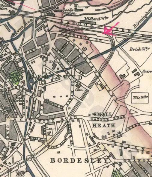
The 1912 OS map shows the exact location with the entrance on the west side of the street, see the following link.

https://images.birminghamhistory.co.uk/coppermine/displayimage.php?album=lastup&cat=10449&pid=11084#top_display_media

Passing through these gates would have lead between the offices on the left and the covered stalls on the right where the stock would be readied for sale.

If you visit the National Heritage Aerofilms website there is an aerial view of Digbeth in the 1920's looking northwards where in the distance the serried roofs of the Cattle Market are visible. (EPW037036.jpg from memory)
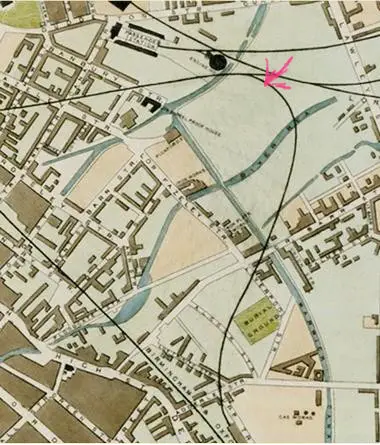
Beyond was where the overbridge beneath the final section of the Duddeston Viaduct existed and which was probably removed at some time after 1890. The map clip shows a building between what are the arch abutments which probably related to the market.

Further north were a number of open stalls or tethers accessed via a second entrance nearby where the Montague Street swings east to pass beneath the LNWR tracks leading to New Street station. This entrance allowed cattle landed at the old Midland railway cattle station at Banbury Street wharf to be lead either to Smithfield Market via the overbridge into Fazeley Street or to Montague Street market passing beneath the penultimate arch of the Viaduct.

This link should take you to a picture showing the Cattle Market from the northern end.

https://warwickshirerailways.com/lms/lnwrcs2158.htm

I visited The National Archive in Kew a few weeks ago and spent a long day poring over some of Brunel's Contract drawings from around 1847-50 which showed how the area looked at the time.

Clearly the area was destined for development as two new road alignments were planned for the immediate area toward the Warwick Canal both requiring wide and tall crossings beneath the Viaduct. This I am sure was for the improved waste treatment plant which I alluded to in an earlier post.

One was at the location of the photograph and headed in a south westerly direction resulting in the very skewed overbridge and the second was where the remaining final abutment remains today and would have headed north west from the point where the present alignment of Montague Street bends shortly after the Great Barr Street junction.

The position today is blocked by a curved brick wall erected no doubt when the Corporation Salvage yard was developed in the 30's.

My present quest is to determine whether these two roads had iron column supported bridges similar to the sole remaining example in Cerros' yard off Liverpool Street which is what Brunel's drawings tantalisingly show or whether they were simpler timber construction.
 
Back
Top