Another thanks Christine.
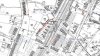
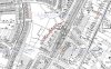
The map shows the two older houses at the end of The Drive on the left. The buildings between the houses were the coach houses and stables. It appeared 'on the ground' (1950's) that The Drive originally came to the front of the houses with a 'turning circle'. The houses faced over the valley rather than onto the road. (The access to the coach houses would have run along the back of the houses.)
I had assumed that this change had been made when the 1930's houses were built, but your map puts this earlier, possibly when the the victorian infill on the right was built. I am again assuming that this infill was down to land purchased for the railway but I could be wide of the mark here as I'm not good with railway dates.
The land attached to the houses going down to the Slade extended to the terrace marked with hash lines on the map. For the first house (the uppermost one on the map) this terrace was occupied by tennis courts with steps down from the main gardens. The boundary beyond the terrace extended southwards to also delineate the garden for the last house. Along the high boundary wall between the houses there were large glasshouses built down the slope. Again these looked contemporaryy with the houses but they are not on the map, so must have been constructed later or missed on the revison.
Beyond the boundary that bordered the terrace was a field that was crossed by a path that gave access to the Slade. Traditionally this was said to have been used as horse pasture. (There were still horses on it in the 1950's) In the 40's, 50's and into the 1960's the first house was occupied by the Coopers, their married daughter and her husband.
Thanks again for the map it fills in a few more blanks.
")