Dennis Williams
Gone but not forgotten
Thanks Phil. I thought for one moment that perhaps Nurse had taken his viewing privileges off him for not taking his medicines...?
And a rather nice tale about another old favourite, in fact the very first entry on this Thread, and the one that prompted it's idea for me...Union Passage, which housed the Cabin, a regular haunt of mine when I'd just started work in 1960, and was coming home from Tech on the bus that stopped outside Rackhams...on the way down to the 53 or 54 in Carrs Lane to get home. This little gem of a boozer, with its enormouus circular copper Bar top and snug seating, tucked down a fascinating Alleyway, off another Alleyway, was always a fatal attraction...something akin to a Dickensian pub to my immature mind then...
Consider what Showell wrote about the Passage in 1880s...

Interesting mention of the Old Bear Yard and of ‘Bear baiting’ in the mid 1800s there, and the specific nomination of the ‘Black Country’ boys as the main perps. Never heard of Old Bear Yard, and can't find any reference on available maps I have?
Funnily enough, in Edwards’ account of The Woolpack, and no doubt because of the proximity of the Moor Street Public Office next door circa 1795, he cites a character George Redfern, evidently one if Birmingham’s finest “peace officers”, and his brave “runners” or “terrors to evil doers” in messrs Palmer, Spittle, Hall and Wesson; and a tale he’d just heard of “Bull Baiting” in the Woolpack snug circa 1825.
George had evidently got word from his Staffordshire counterparts that on a certain day, they had heard that a bull was to be ‘baited’ at Nineveh, in the parish of Handsworth. They thought that when they ‘disturbed’ the perps, they would run off and bring the bull back over the boundary to Brum, and thus into his jurisdiction, and that if he was well supported, and fancied an arrest, he might then “secure the principals”. And thus it transpired that when the Staffs runners hit the event, the stake to which the bull was fastened, was drawn, and the whole party, Bull, dogs, and all the other “brutes’ – crossed the County border, and proceeded to Lodge Road and Soho Pool. It was there they thought it would be safe, so the stake was driven in, the bull tethered, a ring formed, spectators admitted after payment, and bets were made.
The rules were simple, but not sanctioned by the RSPCA - anyone was permitted to let his dog have twelve runs at the bull on payment of six pence. If the dog succeeded to "pin the bull", that is gripping him by the nose so that he could not be shaken off, the dog won half a crown (presumably to spend however he fancied?)... If however, the bull succeeded in disembowelling the dog, or killing it, the owner lost the dog and his sixpence without redress.
Well evidently, this little game was going on with considerable vigour when George and his merry men arrived on the scene. “as soon as they seed we a coming” said the witness, the majority legged it swiftly…
The constables managed, however to secure two of the “berrods” (a corruption of the word “Bear ward” - a keeper of Bear), as well as the Bull itself. They duly removed the stake, bull, and other “properties’ to the stable of The Woolpack. The captive “berrods” who were known as “Bag O’Razzors” and “Black Country Charlie”, then “enjoyed a day or two in the jail at Moor Street, from which they were ultimately allowed to depart by the magistrate Mr Richard Spooner on the payment of £5 and £2 respectively, and being bound over not to repeat the offence without considerable penalty. “ Unfortunately, they still had the bull in custody “in durance vile”, and as he couldn’t be fined, he was sold to get some form of redress for the trouble he caused…THAT was allegedly the end of bull and bear baiting in the City…fat chance….
Well evidently, this little game was going on with considerable vigour when George and his merry men arrived on the scene. “As soon as they seed we a coming” said the witness, the majority ran off swiftly…
The constables managed, however, to secure two of the “berrods” (a corruption of the word “Bear ward” - a keeper of Bear), as well as the Bull itself. They then duly removed the stake, bull, and other “properties' to the stable of The Woolpack. The two captive “berrods” who were rather quaintly known as “Bag O’Razzors” and “Black Country Charlie”, then “enjoyed a day or two in the jail at Moor Street, from which they were ultimately allowed to depart by the magistrate Mr Richard Spooner on the payment of £5 and £2 respectively, and being bound over not to repeat the offence without considerable penalty".
Unfortunately, they still had the bull in custody “in durance vile”, and as he couldn’t be fined, he was sold to get some form of redress for the trouble he'd caused… and THAT was allegedly the end of bull and bear baiting in the City…
Fat chance….

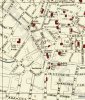
Map 1889

Union Passage showing The Cabin signed on the left...
And a rather nice tale about another old favourite, in fact the very first entry on this Thread, and the one that prompted it's idea for me...Union Passage, which housed the Cabin, a regular haunt of mine when I'd just started work in 1960, and was coming home from Tech on the bus that stopped outside Rackhams...on the way down to the 53 or 54 in Carrs Lane to get home. This little gem of a boozer, with its enormouus circular copper Bar top and snug seating, tucked down a fascinating Alleyway, off another Alleyway, was always a fatal attraction...something akin to a Dickensian pub to my immature mind then...
Consider what Showell wrote about the Passage in 1880s...
Interesting mention of the Old Bear Yard and of ‘Bear baiting’ in the mid 1800s there, and the specific nomination of the ‘Black Country’ boys as the main perps. Never heard of Old Bear Yard, and can't find any reference on available maps I have?
Funnily enough, in Edwards’ account of The Woolpack, and no doubt because of the proximity of the Moor Street Public Office next door circa 1795, he cites a character George Redfern, evidently one if Birmingham’s finest “peace officers”, and his brave “runners” or “terrors to evil doers” in messrs Palmer, Spittle, Hall and Wesson; and a tale he’d just heard of “Bull Baiting” in the Woolpack snug circa 1825.
George had evidently got word from his Staffordshire counterparts that on a certain day, they had heard that a bull was to be ‘baited’ at Nineveh, in the parish of Handsworth. They thought that when they ‘disturbed’ the perps, they would run off and bring the bull back over the boundary to Brum, and thus into his jurisdiction, and that if he was well supported, and fancied an arrest, he might then “secure the principals”. And thus it transpired that when the Staffs runners hit the event, the stake to which the bull was fastened, was drawn, and the whole party, Bull, dogs, and all the other “brutes’ – crossed the County border, and proceeded to Lodge Road and Soho Pool. It was there they thought it would be safe, so the stake was driven in, the bull tethered, a ring formed, spectators admitted after payment, and bets were made.
The rules were simple, but not sanctioned by the RSPCA - anyone was permitted to let his dog have twelve runs at the bull on payment of six pence. If the dog succeeded to "pin the bull", that is gripping him by the nose so that he could not be shaken off, the dog won half a crown (presumably to spend however he fancied?)... If however, the bull succeeded in disembowelling the dog, or killing it, the owner lost the dog and his sixpence without redress.
Well evidently, this little game was going on with considerable vigour when George and his merry men arrived on the scene. “as soon as they seed we a coming” said the witness, the majority legged it swiftly…
The constables managed, however to secure two of the “berrods” (a corruption of the word “Bear ward” - a keeper of Bear), as well as the Bull itself. They duly removed the stake, bull, and other “properties’ to the stable of The Woolpack. The captive “berrods” who were known as “Bag O’Razzors” and “Black Country Charlie”, then “enjoyed a day or two in the jail at Moor Street, from which they were ultimately allowed to depart by the magistrate Mr Richard Spooner on the payment of £5 and £2 respectively, and being bound over not to repeat the offence without considerable penalty. “ Unfortunately, they still had the bull in custody “in durance vile”, and as he couldn’t be fined, he was sold to get some form of redress for the trouble he caused…THAT was allegedly the end of bull and bear baiting in the City…fat chance….
Well evidently, this little game was going on with considerable vigour when George and his merry men arrived on the scene. “As soon as they seed we a coming” said the witness, the majority ran off swiftly…
The constables managed, however, to secure two of the “berrods” (a corruption of the word “Bear ward” - a keeper of Bear), as well as the Bull itself. They then duly removed the stake, bull, and other “properties' to the stable of The Woolpack. The two captive “berrods” who were rather quaintly known as “Bag O’Razzors” and “Black Country Charlie”, then “enjoyed a day or two in the jail at Moor Street, from which they were ultimately allowed to depart by the magistrate Mr Richard Spooner on the payment of £5 and £2 respectively, and being bound over not to repeat the offence without considerable penalty".
Unfortunately, they still had the bull in custody “in durance vile”, and as he couldn’t be fined, he was sold to get some form of redress for the trouble he'd caused… and THAT was allegedly the end of bull and bear baiting in the City…
Fat chance….
Map 1889
Union Passage showing The Cabin signed on the left...
Last edited: