Lloyd
master brummie
What service did you use to search for that information, was it Ancestry or Find My Past or something else?
What service did you use to search for that information, was it Ancestry or Find My Past or something else?
Sorry no, our street party was of Lee Bank, it was on Elvetham Rd, small Rd Island at the bottom and Bell Barn Rd ran across, we had a tin with chocolates in I believe, shame no pictures took, none I knew of anyway.Hi Does anyone have a photo of the Bankes Road party for the Coronation?.
Regards
RosieT
Hi any idea where this was as I note the cafe is called The Boulevard - might it be in Quinton?gooch st highgate dated 1967
View attachment 117391
rear of st martins st edgbaston dated 1967
View attachment 117392
stechford road yardley dated 1928
View attachment 117393
shaftsmoor lane dated 1962
View attachment 117394
I think the Editions B42 relates to the publisher, they are a French Publisher.The area B42 is shown on the map here View attachment 173505
Yes looks like Stratford rd junction with School Road/Colebank rd, Hall Green College on left, The Horseshoe Pub on right,Had second thoughts, Stratford Road is the A34 so coming up to the ringway along there maybe
I did wonder that?Scott Arms perhaps.
Yes I agree although I have a slight problem with the Horseshoe Pub although it has changed a lot over the years. The website from the link below is interesting .... click on the pic to see written contentYes looks like Stratford rd junction with School Road/Colebank rd, Hall Green College on left, The Horseshoe Pub on right,
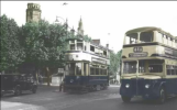
No.11 Outer Circle bus crossing
This is a shot from 2009, just past a bus stop on left (yellow dotted lines), note large tree branches on left as in photoYes I agree although I have a slight problem with the Horseshoe Pub although it has changed a lot over the years. The website from the link below is interesting .... click on the pic to see written content

The excellent link shown by oldMohawk has the photo in very high resolution.Yes I agree although I have a slight problem with the Horseshoe Pub although it has changed a lot over the years. The website from the link below is interesting .... click on the pic to see written content

Would you believe this was the same view in 2011, although it went back to the 2009 view later. Large tree removed.This is a shot from 2009, just past a bus stop on left (yellow dotted lines), note large tree branches on left as in photo
middle left: same slip road from Hall Green Library & Telephone Exchange
View attachment 173515

Thanks!Yes I agree although I have a slight problem with the Horseshoe Pub although it has changed a lot over the years. The website from the link below is interesting .... click on the pic to see written content

How did I not recognise this picture? I went to school in 1950's on number 11 bus route, on same route to work in 1960's through this junction, even went to Hall Green tech for a while. I still remember that School Rd and Colebank Rd were misaligned with a layby where you could park for a quick getaway after college, that there was an Atco mower shop on the corner of School Rd and a fashion shop on the opposite side that had the same name as a film actress, Jill Ireland.Yes looks like Stratford rd junction with School Road/Colebank rd, Hall Green College on left, The Horseshoe Pub on right,
No.11 Outer Circle bus crossing
 www.google.co.uk


")