-
Welcome to this forum . We are a worldwide group with a common interest in Birmingham and its history. While here, please follow a few simple rules. We ask that you respect other members, thank those who have helped you and please keep your contributions on-topic with the thread.
We do hope you enjoy your visit. BHF Admin Team
You are using an out of date browser. It may not display this or other websites correctly.
You should upgrade or use an alternative browser.
You should upgrade or use an alternative browser.
Avenue Street
- Thread starter Astoness
- Start date
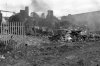
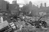

hi phil avenue road has just sprung to mind and could very well be the one...i could ask the person who took these photos over many years...(about 33000 in all) in the hopes he can remember..looking at the locations of some of them he was out and about around nechells way etc...
Phil
Gone, but not forgotten.
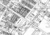
phil i have just had a better look at those 2 pic and it looks to me as though they are of the backs of the houses not the fronts so is it possible that the caption should have read..old houses taken from avenue st making them actually in the next st or road to avenue road../st...are we certain there was no avenue st?
john knight
signman
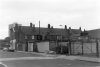
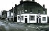
I knew Avenue Road quite well, don't recognise any of these photos.
pjmburns
master brummie
I don't know if this helps or not but there was a planning update dated November 1993 for "LAND RECLAMATION SCHEME COMPRISING DEMOLITION,SITE INVESTIGATION,REMOVAL OF TIPPED MATERIAL & SCREEN WALL" the site was listed as "ASTON ROAD NORTH/ROCKY LANE/ CHESTER STREET/AVENUE ROAD -LAND BOUNDED BY ASTON"
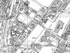
The photo looks to me like The Avenue Pub - I have to say I don't know the area so am going on looks alone seen in the photos in both #9 and #1. I also agree that the maps seem to make the date wrong for the demolition.
The photo looks to me like The Avenue Pub - I have to say I don't know the area so am going on looks alone seen in the photos in both #9 and #1. I also agree that the maps seem to make the date wrong for the demolition.
Phil
Gone, but not forgotten.
What I think has happened here is, as suggested by Lyn although the photo has been taken from Avenue Road it is actually the shops and pub on Aston Road North that are being demolished we are seeing them from the rear. The large gable end of the building we can see in the one photo is still standing in this Google image, we can also see the access to the site where the photo was taken from. Incidentally the large building in the photo is the one that bears the blue plaque dedicated to Sir Arthur Conan Doyle.
