Qu.Be
Heróiam sláva
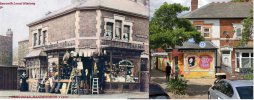
I've seen a Facebook Image, circa 1900, in the Nhóm lịch sử địa phương / (Handsworth) Local History Group, showing a hardware shop on a corner of Piers Road; the name on the shop window appears to be 'W Duddleston'. The shop is claimed to be on the corner of Soho Rd and Piers Road, but the buidings there currently look older than the claimed date and the National Library of Scotland map resources seem to show that the corner had been built up for quite some time prior to the picture.
Could I trouble anybody with access to references of the period to see where W. Duddleston's shop actually was?
Thanks, as they say, In Advance, QuinB.
Could I trouble anybody with access to references of the period to see where W. Duddleston's shop actually was?
Thanks, as they say, In Advance, QuinB.